This item has been sold, but you can get on the Waitlist to be notified if another example becomes available, or purchase a digital scan.
1850 Mitchell Map of Ontario, Upper Canada or Canada West
CanadaWestUpper-mitchell-1850$75.00

Title
Canada West formerly Upper Canada.
1850 (undated) 12.5 x 16 in (31.75 x 40.64 cm) 1 : 2011680
1850 (undated) 12.5 x 16 in (31.75 x 40.64 cm) 1 : 2011680
Description
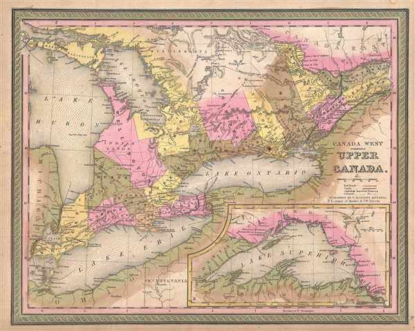
This is an 1850 Samuel Augustus Mitchell map of the Canadian province of Ontario, or Canada West. Centered on Lake Ontario, this map depicts from Lake Erie, Detroit, Michigan and Lake Huron to Quebec. Lake Huron and Lake Ontario are labeled, and Georgian Bay is labeled Lake Iroquois. Numerous towns and villages are noted, including Buffalo, New York. Niagara Falls is also labeled. In the lower right corner, an inset map of Lake Superior is also illustrated.
Canadian provinces and territories were under British and French control from the 16th century, until France gave up its claims in the Treaty of Paris in 1763. Canada would remain a collection of British colonies until its confederation in 1867, when the British Province of Canada was divided into Quebec and Ontario and the British colonies of New Brunswick and Nova Scotia were incorporated as Canadian provinces.
Mitchell published this chart in his atlas from 1846 to the late 1850s before discontinuing the series and selling his map plates to DeSilver. This map was issued in the 1850 edition of the New Universal Atlas.
Cartographer
Samuel Augustus Mitchell (March 20, 1792 - December 20, 1868) began his map publishing career in the early 1830s. Mitchell was born in Bristol, Connecticut. He relocated to Philadelphia in 1821. Having worked as a school teacher and a geographical writer, Mitchell was frustrated with the low quality and inaccuracy of school texts of the period. His first maps were an attempt to rectify this problem. In the next 20 years Mitchell would become the most prominent American map publisher of the mid-19th century. Mitchell worked with prominent engravers J. H. Young, H. S. Tanner, and H. N. Burroughs before attaining the full copyright on his maps in 1847. In 1849 Mitchell either partnered with or sold his plates to Thomas, Cowperthwait and Company who continued to publish the Mitchell's Universal Atlas. By about 1856 most of the Mitchell plates and copyrights were acquired by Charles Desilver who continued to publish the maps, many with modified borders and color schemes, until Mitchell's son, Samuel Augustus Mitchell Junior, entered the picture. In 1859, S.A. Mitchell Jr. purchased most of the plates back from Desilver and introduced his own floral motif border. From 1860 on, he published his own editions of the New General Atlas. The younger Mitchell became as prominent as his father, publishing maps and atlases until 1887, when most of the copyrights were again sold and the Mitchell firm closed its doors for the final time. More by this mapmaker...
Source
Mitchell, S. A., A New Universal Atlas, (S. A. Mitchell; Philadelphia) 1850.
The New Universal Atlas is one of the great American atlases of the mid-19th century. Samuel Augustus Mitchell first issued the atlas in 1846 when he acquired the map plates and copyright for Tanner's New Universal Atlas from its publisher, Carey and Hart. The first transitional 1846 edition was published jointly with Carey and Hart, but a second edition was published in the same year with the Tanner imprint erased. This edition of the atlas also introduced the signature S. A. Mitchell green and pink color scheme. Most of the maps from the early editions of the atlas were engraved by H. N. Burroughs or C. S. Williams, often bearing their copyright. Burroughs maps also tended to have what map collector David Rumsey refers to as the 'Cary and Hart' borders, which featured a narrow vine motif. These borders were replaced, along with the Burroughs imprint, with the more traditional Mitchell strap work border used in the atlases until 1856. Mitchell published editions until late in 1850, when he sold the rights to Thomas, Cowperthwait and Company of Philadelphia. Under Cowperthwait, the atlases continued to be published and bear the Mitchell name until 1856, when the plates were again sold, this time to Charles Desilver. Desilver reworked the plates with new border art and a revised color scheme in the style of J. H. Colton. Desilver issued editions from 1857 to 1860, when the atlas was phased out in favor of Samuel Augustus Mitchell Jr.'s New General Atlas.
Condition
Very good. Even overall toning. Minor foxing. Closed margin tear professionally repaired on verso. Blank on verso.
References
Rumsey 4835.009.