This item has been sold, but you can get on the Waitlist to be notified if another example becomes available, or purchase a digital scan.
1927 Canadian Pacific Bird's-Eye View Map of Canadian Rocky Mountains
CanadianRockies-canadianpacific-1927$250.00


Title
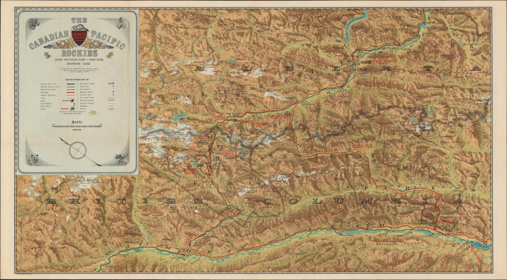
The Canadian Pacific Rockies: Rocky Mountains Park - Yoho Park - Kootenay Park.
1927 (dated) 17.5 x 31.25 in (44.45 x 79.375 cm) 1 : 380000
1927 (dated) 17.5 x 31.25 in (44.45 x 79.375 cm) 1 : 380000
Description
This 1927 Canadian Pacific Railway pictorial map of the Canadian Rocky Mountains in Alberta and British Columbia was created to cultivate outdoor adventure tourism.
We are unable to verify other examples of this printing of the map (in Canada, not corrected to 1928) in institutional collections, but due to the complications just mentioned, it is possible that some of the examples listed in the OCLC were also printed in Toronto, especially those held by Canadian institutions (the University of Calgary, the Library and Archives Canada, and the Bibliothèque et Archives nationales du Québec).
A Closer Look
Oriented toward the northeast, the Canadian Pacific Railway cuts across the mountains from top-right towards bottom-left. Roads and highways shadow the railroad's route, hinting at the imminent decline of passenger rail travel. An adventurer's playground, the map highlights miles of hiking trails, unobtrusively reinforcing the opportunity available to the outdoor enthusiast. Hotels and campsites are also noted. Tourists' favorites, such as Lake Louise and Banff, are emphasized. On the other hand, the lines of the competing Canadian National Railway are not included, obscured by the title box at top-left.Canadian Pacific Railway Network Map
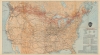
A Canadian Pacific Railway network map occupies the verso. Canadian Pacific's extensive network is highlighted in red, with all stops labeled. Cities within the United States printed in red have Canadian Pacific offices. Major railroads within the United States are traced and labeled, with major stops identified.Publication History and Census
This map was compiled and drawn under the supervision of Arthur O. Wheeler and published by the Canadian Pacific Railway Company in 1927. This appears to be a scarce printing of this map; the OCLC notes several institutions holding a map printed in the U.S.A., while the present example was lithographed by Ralph Clark Stone in Toronto. Some examples are copyrighted to 1927 but are noted as 'corrected to October 1928' in the bottom-right corner of the recto (including an example previously sold by us; the two can be easily distinguished by the word 'Pacific' in the title here). The inclusion of 1926 below the scale bar in the title box in the recto only confuses matters more.We are unable to verify other examples of this printing of the map (in Canada, not corrected to 1928) in institutional collections, but due to the complications just mentioned, it is possible that some of the examples listed in the OCLC were also printed in Toronto, especially those held by Canadian institutions (the University of Calgary, the Library and Archives Canada, and the Bibliothèque et Archives nationales du Québec).
Cartographer
Arthur Oliver Wheeler (May 1, 1860 - March 20, 1945) was an Irish Canadian surveyor and mountaineer. Born in Lyrath, Ireland, Wheeler attended schools Ballinasloe College in County Galway, Ireland, and Dulwich College in London before moving to Canada in 1876. For the next nine years he worked in midwestern Canada as a surveyor, when, in 1885, he was appointed to the Surveys branch of the Department of the Interior under Dr. Deville. Deville, the originator of Canadian photo-topographical methods, taught Wheeler these methods and how to be a mountain topographer while mapping parts of the Canadian Rocky Mountains. Wheeler then elected to start his own surveying firm in 1890, but by 1893 he had returned to the Department of the Interior. Then, starting in 1895, he began working on surveying projects that lasted almost continuously until 1925 and the completion of the Alb3erta-British Columbia provincial boundary survey. During these thirty years, Wheeler worked on projects for the Canadian Pacific Railway, and he took part in surveying the International Boundary between Alaska and the Yukon Territory, then being arbitrated in London. He returned to private practice in 1910, but remained out of government service only until 1913, when he was named Commissioner for British Columbia on the Interprovincial Boundary Survey, mapping and surveying over 600 miles of the main range Rocky Mountains along the Continental Divide. Wheeler helped found the Alpine Clube of Canada (ACC) and the Canadian Alpine Journal. Wheeler served as President of the ACC from 1906 through 1910, and as Managing Director from 1907 until 1930. Wheeler served as Editor of the Journal until 1926. He was Honorary President of the ACC from 1926 until his death. He married Clara Macoun in 1887, who passed away in 1923. He married Emmeline Savatard in 1924. He had one son. More by this mapmaker...
Condition
Very good. Small marginal wear repaired and reinforced on verso.
References
OCLC 228505050.