This item has been sold, but you can get on the Waitlist to be notified if another example becomes available, or purchase a digital scan.
1875 Imray Blueback Nautical Chart or Map of the Carnary Islands
CanaryIslands-imray-1875$475.00

Title
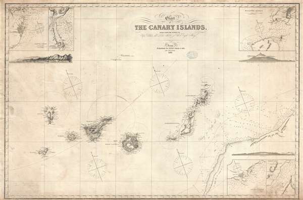
Chart of the Canary Islands, Drawn from the Surveys of Capt. Vidal and Liet. Arlett of the Royal Navy.
1875 (dated) 26 x 40 in (66.04 x 101.6 cm) 1 : 818000
1875 (dated) 26 x 40 in (66.04 x 101.6 cm) 1 : 818000
Description
An elegant 1875 James Imray nautical chart or map of the Canary Islands. This map was originally published by Imray in 1860, the present example being a later edition, based upon the important surveys of Captain Alexander Thomas Emeric Vidal of the Royal Navy. Centered on Gran Canaria, the map extends to cover all of the islands as well as parts of the adjacent west African coast. Insets details Santa Cruz (Tenerife), Puerto da la Luz (Las Palmas, Gran Canaria), Arreciffe (Arrecife, Lanzarote), the Strait of Rio, and Bocayna Strait. Profiles detail Tenerife, Grand Canaria, and Santa Cruz.
Vidal and Arlett Surveys
Vidal and Arlett completed a series of surveys of the African Coast, Madeira, and Canary Islands in from 1838, but specifically around the Canary Islands in 1844. Before Vidal, this area was poorly mapped and a haven for slavers and pirates. Vidal's achievement in surveying the region was praised by the Secretary of the Royal Geographical SocietyThis tedious undertaking is drawing to a close, and will then be of equal utility to the fair traders and the anti-slavery cruisers. It is fortunately in the hands of such a man as Captain Vidal, R.N., who has steadily devoted himself during a long period of ill-health, to complete this unpopular work, and to connect with it a minute examination of the Canary Islands.His work laid the groundwork for all subsequent maps of the Canary Islands.
Blueback Charts
Blueback nautical charts began appearing in London in the late 18th century. Bluebacks, as they came to be called, were privately published large format nautical charts known for their distinctive blue paper backing. The backing, a commonly available blue manila paper traditionally used by publishers to warp unbound pamphlets, was adopted as a practical way to reinforce the low-quality paper used by private chart publishers in an effort to cut costs. The earliest known blueback charts include a 1760 chart issued by Mount and Page, and a 1787 chart issued by Robert Sayer. The tradition took off in the early 19th century, when British publishers like John Hamilton Moore, Robert Blachford, James Imray, William Heather, John William Norie, Charles Wilson, David Steel, R. H. Laurie, and John Hobbs, among others, rose to dominate the chart trade. Bluebacks became so popular that the convention was embraced by chartmakers outside of England, including Americans Edmund March Blunt and George Eldridge, as well as Scandinavian, French, German, Russian, and Spanish chartmakers. Blueback charts remained popular until the late 19th century, when government subsidized organizations like the British Admiralty Hydrographic Office and the United States Coast Survey, began issuing their own superior charts on high quality paper that did not require reinforcement.Publication History and Census
This map appears surprisingly rare. We have identified advertisements for it in Imray's catalog, but no other examples either in institutional or private collections. Nor are there available sales records for this map in the last 30 years. This map is owned jointly by Geographicus and Vetus Carta Maps.Cartographer
James Imray (May 16, 1803 - November 15, 1870) was a Scottish hydrographer and stationer active in London during the middle to latter part of the 19th century. Imray is best known as a the largest and most prominent producer of blue-back charts, a kind of nautical chart popular from about 1750 to 1920 and named for its distinctive blue paper backing (although not all charts that may be called "blue-backs" actually have a blue backing). Unlike government charts issued by the British Admiralty, U.S. Coast Survey, and other similar organizations, Imray's charts were a private profit based venture and not generally the result of unique survey work. Rather, Imray's charts were judicious and beautiful composites based upon pre-existing charts (some dating to the 17th century) and new information gleaned from governmental as well as commercial pilots and navigators. Imray was born in Spitalfields, England, the eldest son of a Jacobite dyer also named James. Imray did not follow his father profession, instead apprenticing to William Lukyn, a stationer. He established himself as a bookseller and bookbinder at 116 Minories Street, where he shared offices with the nautical chart publisher Robert Blanchford. In 1836 Imray signed on as a full partner in Blanchford's enterprise, christening themselves Blanchford & Imray. At this time the Blanchford firm lagged far behind competing chart publishers Norie and Laruie, nevertheless, with the injection of Imray's marketing savvy the firm began a long rise. James Imray bought out Blanchford's share in 1846, becoming the sole proprietor of the chart house, publishing under the imprint of James Imray. Relocating in 1850 to larger offices at 102 Minories, Imray was well on track to become the most prominent chart publisher in London. In 1854, when Imray's 25 year old son, James Frederick Imray, joined as a full partner, the firm again changed its imprint, this time to James Imray and Son. The elder Imray was a master of marketing and was quick to respond to trade shifts and historic events. Many of his most successful charts were targeted to specific trade routes, for example, he issued charts entitled "Cotton Ports of Georgia" and "Rice Ports of India". Other charts emerged quickly following such events as the 1849 California Gold Rush. Imray's rise also coincided with the development of governmental mapping organizations such as the Admiralty and the U.S. Coast Survey, whose work he appropriated and rebranded in practical format familiar to navigators. Imray's death in 1870 marked a major transition in the firm's output and began its decline. Though Imray's son, James Frederick, excelled at authoring pilot books he had little experience with charts and issued few new publications. Most James Frederick Imray publications issued from 1870 to 1899 were either revisions of earlier maps prepared by his father or copies of British Admiralty charts. Charts from this period are recognizable as being less decorative than the elder Imray's charts following the stylistic conventions established by the Admiralty. The Admiralty itself at the same time began to rise in prominence, issuing its own official charts that were both cheaper and more up to date than those offered by private enterprises. By the end of the century the firm was well in decline and, in 1899 "James Imray and Son" amalgamated with the similarly suffering "Norie and Wilson", which was itself acquired by Laurie in 1904. Today it continues to publish maritime charts as "Imray, Laurie, Norie and Wilson". More by this mapmaker...
Condition
Very good. Some creasing. Backed on blue paper.