This item has been sold, but you can get on the Waitlist to be notified if another example becomes available, or purchase a digital scan.
1905 Depot de la Marine Nautical Chart or Maritime Map of Cape Breton Island
CapeBretonIsland-depotmarine-1905$350.00

Title
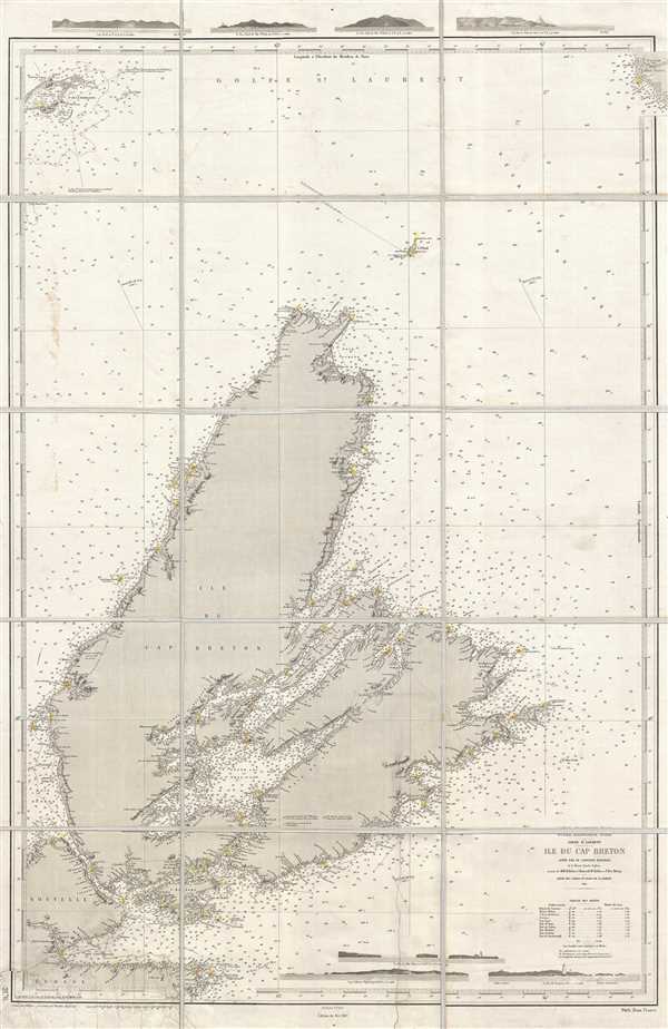
Océan Atlantique Nord. Golfe St. Laurent. Ile du Cap Breton.
1905 (dated) 40.5 x 26.5 in (102.87 x 67.31 cm) 1 : 292000
1905 (dated) 40.5 x 26.5 in (102.87 x 67.31 cm) 1 : 292000
Description
This is a 1905 Dépôt des Cartes et Plans de la Marine nautical chart or maritime map of Cape Breton Island, Canada. It is extremelyt difficult to find any specific maps of Cape Breton Island, this being only the second we have seen in nearly 20 years. The map depicts the whole of Cape Breton Island from Nova Scotia (Nouvelle Ecosse) to Newfoundland (Terre Neuve) and from the Magdalen Islands (Is. de la Madeleine), the Gulf of St. Lawrence, and Newfoundland to Nova Scotia. Presenting a highly detailed illustration of the coastline of Cape Breton Island, this chart evidently bears myriad information important to the mariner. Landmarks along the coast are labeled, such as points and bays. The locations of lighthouses and light-boats are noted all along the coast by yellow and red notations which were added by hand after printing. Innumerable depth soundings populate the map, particularly around the coastlines, which are given in meters. Several profile views are included along the top and bottom borders illustrating different sections of coastline, some of which bear a lighthouse. A tide table is situated in the lower right corner above the profile views and below the title.
This map was produced by the Dépôt des Cartes et Plans de la Marine from Royal Navy records in 1905.
This map was produced by the Dépôt des Cartes et Plans de la Marine from Royal Navy records in 1905.
Cartographer
Dépôt des Cartes et Plans de la Marine (fl. 1720 - present), often called the Dépôt de Marine, was a French hydrographic mapping organization founded in 1720 under Charles-Hercule of Albert de Luynes (1674 - 1734). Much like the U.S. Coast Survey, the British Admiralty, and the Spanish Deposito Hydrografico, the Dépôt was initiated as a storehouse and distribution center of existing nautical and marine charts. Eventually the Dépôt initiated its own mapping activities in an attempt to improve and expand upon existing material. Some of the more prominent cartographers and hydrographers associated with the of Dépôt des Cartes were, Philippe Buache, Jacques-Nicholas Bellin, Giovanni Rizzi-Zannoni, Rigobert Bonne, and Jean Nicolas Buache. More by this mapmaker...
Condition
Very good. Dissected into 15 sections and mounted on linen. Repaired tear extending 11.5 inches into printed area from bottom margin. Repaired tear extending 6 inches into printed area from left margin. Blank on verso.
References
OCLC 81047865.