
This item below is out of stock, but another example (left) is available. To view the available item, click "Details."
Details
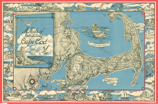
1950 Miller Pictorial Map of Cape Cod, Massachusetts
1950 (undated) $950.00
1945 Miller Map of Cape Cod, Massachusetts
CapeCod-miller-1945$250.00

Title
A Map of Interesting Cape Cod.
1945 (undated) 22 x 33 in (55.88 x 83.82 cm)
1945 (undated) 22 x 33 in (55.88 x 83.82 cm)
Description
This unusual map of Cape Cod was drawn in 1945 by F. J. Miller. Covers all of Cape Cod as well as parts of the adjacent South Shore including New Bedford, Fairhaven, Plymouth, Buzzard Bay, and Duxbury. Names important towns and roads in addition to offering a wealth of border vignettes showing various aspects of Cape Cod life from fishing to sunbathing, to gathering clams and mussels. A rope motif border alludes to the region's nautical heritage.
This is considered a 'pictorial map' or a 'decorative map,' and reflects a style that first began to appear around 1910. As a map its intention is not so much to provide direction as to illustrate the character, famous places, and historical appeal of Cape Cod. Cartographically speaking, this map style most likely draws its inspiration from late 19th century 'tourist maps' and 'railroad maps.' Tourist Maps, common to major cities in Europe (usually Paris or London), included profiles of notable buildings and monuments and were designed to help foreign tourists identify and navigate to the most important sights. 'Railroad Maps' are a related genre more common to the United States. During the latter part of the 19th century railroad boom, railroad companies began issuing decorative route maps extolling the virtues various regions and their accessibility by rail. Standing somewhere between this two map styles, our map combines the decorative aspects of both while reducing cartographic value. It may be hard to get from A to B using this map, but its attractive design and decorative flourishes, make it an excellent souvenir and memento of a wonderful Cape Cod vacation.
This map is copyrighted to F. J. Miller of 1045 High Street, Westwood, Massachusetts. The W.E.B. Du Bois Library of UMass Amherst has a nearly identical map ascribed to one Mary E. Murray that does not have Miller's copyright information. The main difference between the two is that the Miller map has a red border and was printed using a three color lithograph process whereas the Murray examples use only a two color process. Of the two variants, the Miller map appears with considerably less frequency. As to which came first, it is nearly impossible to tell, but certainly both are of a vintage.
Condition
Very good. Minor damage to lower left border - could be matted out.
References
UMass Amherst, W.E.B. Du Bois Library, G3762.C35 A5 1945 .M8.