1951 Miller Pictorial Map of Cape Cod
CapeCod-miller-1951$225.00

Title
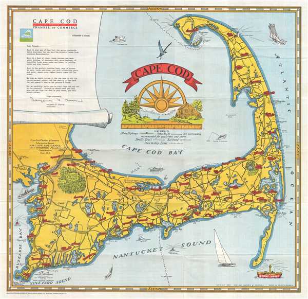
Cape Cod.
1951 (dated) 19.5 x 20.25 in (49.53 x 51.435 cm) 1 : 145000
1951 (dated) 19.5 x 20.25 in (49.53 x 51.435 cm) 1 : 145000
Description
This is a William A. Miller Jr. pictorial map of Cape Cod from the Cape Cod Canal and Buzzards Bay to the Atlantic Ocean and from Race Point and Provincetown to Vineyard Sound and Nantucket Sound. Attractively colored and visually engaging, towns and villages throughout Cape Cod are labeled with red banners bearing the town names. Woods Hole, Falmouth, Hyannis, Barnstable, and Provincetown are among the labeled towns. Nickerson State Park and Shawme Forest are illustrated as pockets of green filled with trees and both are labeled. A pair of airplanes are depicted flying over Cape Cod, and a train is drawn passing the Hyannis airport on its way to Hyannis. A decorative title cartouche is situated in Cape Cod Bay and features part of a compass rose rising above an idyllic scene from a hamlet on Cape Cod. Boats, lighthouses, and various sea birds are included along, in, or flying above the water around the Cape, and the Pilgrim Monument is illustrated in Provincetown. A note extolling the natural beauty and serenity of Cape Cod written the Cape Cod Chamber of Commerce is printed in the upper left corner.
This map was drawn by William A. Miller and published by the Cape Cod Chamber of Commerce in 1951.
This map was drawn by William A. Miller and published by the Cape Cod Chamber of Commerce in 1951.
Condition
Very good. Light wear along original fold lines. Text on verso.