1953 Miller Pictorial Map of Cape Cod
CapeCod-miller-1953$150.00


Title
Cape Cod.
1953 (dated) 20 x 25.5 in (50.8 x 64.77 cm) 1 : 145000
1953 (dated) 20 x 25.5 in (50.8 x 64.77 cm) 1 : 145000
Description
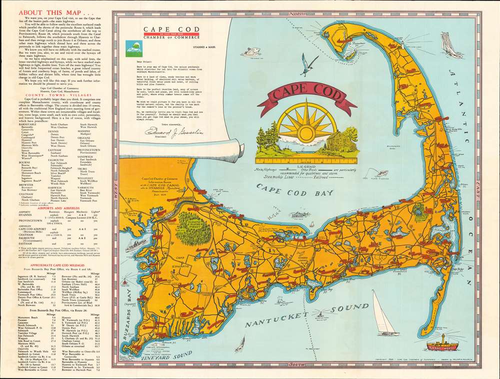
This is a 1953 William A. Miller Jr. pictorial map of Cape Cod. Depicting the region from Buzzards Bay to the Atlantic Ocean and from Race Point to Woods Hole, red banners proclaim the area's towns and villages. Roads railroads crisscross the peninsula, and a train passes the Hyannis Airport. Shawme Forest and Nickerson State Park stand out as pockets of green against the yellow color scheme. Other pictorial elements include boats, airplanes, and the Pilgrim Monument in Provincetown. A decorative cartouche occupies most of Cape Cod Bay. The Sun, which also happens to be the map's compass, rises over an idyllic scene of a country road leading to the beach with a farmhouse off to one side. Tourist information, provided along the left side of the sheet, details the area's towns, airports, and distances between them.
Publication History and Census
This map was created by William A. Miller Jr. and published by the Cape Cod Chamber of Commerce in 1953. At least one other edition, published in 1951, is known, but we have not seen an example of the 1951 edition with the additional information provided along the present example's left side. Six examples of the 1953 edition are cataloged in OCLC. They are part of the collections at the State Library of Massachusetts, the University of Michigan, Ball State University, Southern Illinois University, the University of Wisconsin - Milwaukee, and the University of Kansas.Condition
Very good. Exhibits light wear and toning along original fold lines. Promotional text on verso.
References
OCLC 43703941.