1902 Walker Cycling Map of Cape Cod, Nantucket, Martha's Vineyard, Massachusetts
CapeCod-walker-1902$600.00


Title
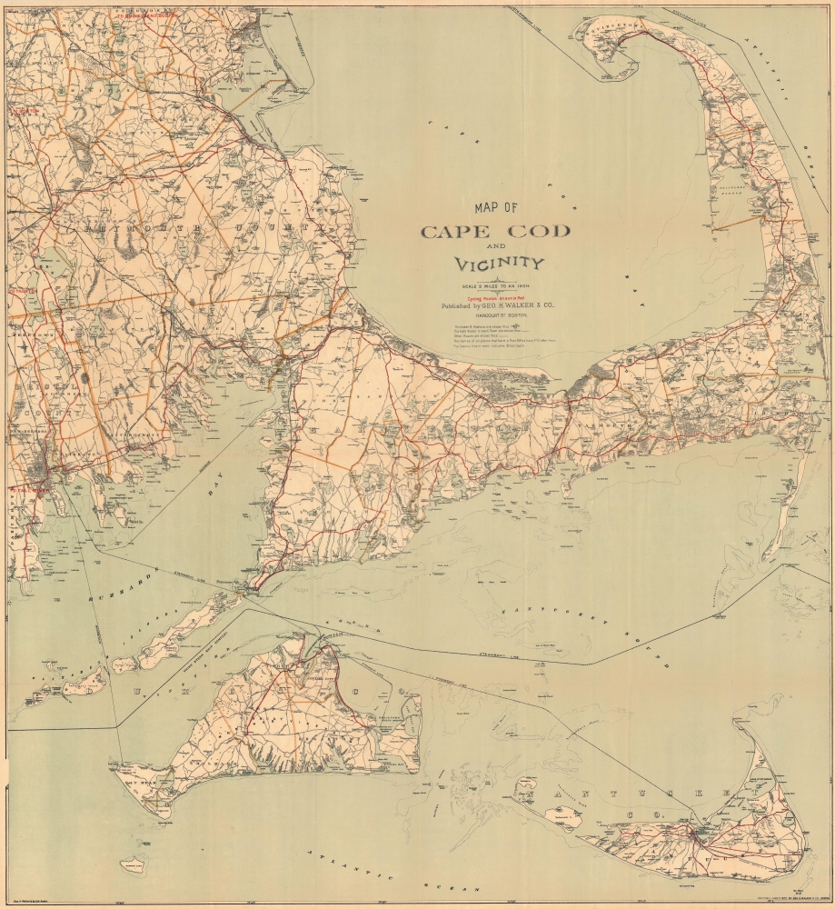
Map of Cape Cod and Vicinity.
1902 (dated) 30.5 x 28 in (77.47 x 71.12 cm) 1 : 126720
1902 (dated) 30.5 x 28 in (77.47 x 71.12 cm) 1 : 126720
Description
A charming 1902 map of Cape Cod, Nantucket, Martha's Vineyard, and other points along the coast of Massachusetts, published by George H. Walker and Company. Rich in information, it focuses in particular on cycling routes, reflecting the boom in recreational cycling in the preceding years.
A Closer Look
The map depicts the region from New Bedford east to the Atlantic Ocean and from Duxbury and Provincetown south to Nantucket. Cycling routes are traced in red, with further connections to Boston, Quincy, Taunton, and Fall River suggested, indicating the main selling point of the map. Other roads, railroad lines, and ferry and steamship lines are also noted, providing comprehensive transportation information to the traveler and local alike. Town borders are outlined in orange. Waterways, swamps, shoals, and other maritime and coastal features are also illustrated.The Bicycle Boom
Though invented in the early 19th century, bicycles only became commercially accessible and popular in the closing decades of the 19th century. A range of innovations made the machines more reliable, safe, comfortable, and affordable, and they became fashionable for their applications in transportation, leisure, and sport on both sides of the Atlantic. As would later happen with automobiles, cycling clubs sprang up to scour best routes, advocate for improved roads, and connect enthusiasts (for instance, the Massachusetts Bicycle Club was founded in 1879 in Boston). Cycling was particularly popular among women, as it provided freedom of movement and association (the sexes could intermingle without parental oversight). With regard to the present map, the quaint small towns and seaside roads of Cape Cod, Nantucket, and Martha's Vineyard were especially well-suited for bicycles.Publication History and Census
This map was created and published by George H. Walker and Company in 1902, updating an earlier 1892 map. Yale University and the American Antiquarian Society list the 1892 edition among their holdings, but we are unable to locate any examples of the 1902 edition in institutional collections or on the market.Cartographer
George Hiram Walker (January 4, 1852 - November 14, 1927) was a Boston based publisher of books, views, and maps active in the late 19th and early 20th centuries. Born in Springfield, Vermont, Walker started his life as a dry goods merchant but developed an active interest in publishing during the early 1870s. Walker began publishing in 1878 when he partnered with an unknown New York Firm. Two years later, Walker brought the operation in house by partnering with his brother, Oscar W. Walker, in the opening of a lithography studio at 81 Milk Street, Boston. Shortly thereafter the firm expanded to new offices at 160 Tremont Street, Boston. The Walker brothers produced a large corpus of works, most of which focused on travel and tourism in New England. Walker also established the Walker-Gordon Milk Laboratory with Dr. Thomas Morgan Rotch and Gustave Gordon. This interesting investment was based on the premise that infant deaths could be avoided by providing higher quality milk. The company eventually became a great success, producing a high-quality cow milk that closely resembled human breast milk. In the process the Walker-Gordon laboratory developed many of the dairy health standards that are still with us today. Walker married Irene L. Loud on March 25, 1885. More by this mapmaker...
Condition
Very good. Minor verso reinforcement along some old fold lines and intersections. Light toning along old fold lines. Detached but accompanied by original binder.