This item has been sold, but you can get on the Waitlist to be notified if another example becomes available, or purchase a digital scan.
1853 U.S. Coast Survey Map of Cape Fear, North Carolina
CapeFear2-uscs-1853$175.00

Title
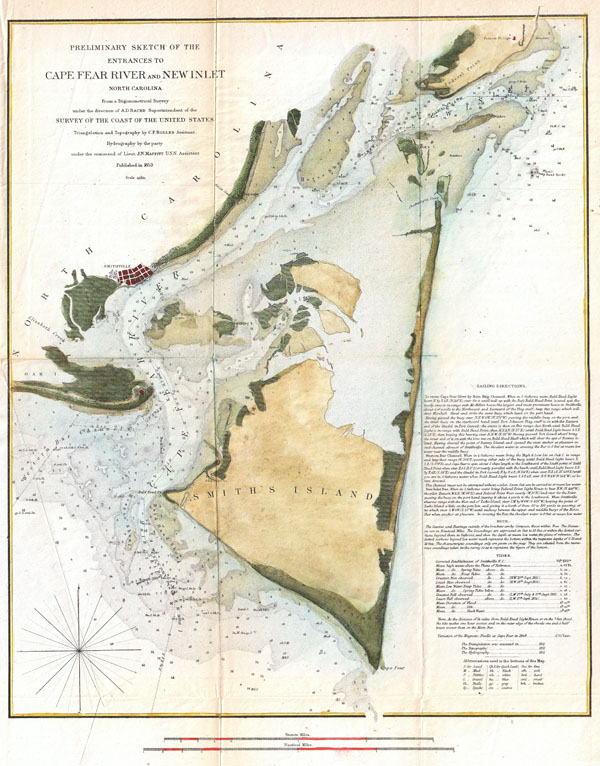
Preliminary Chart of the Entrances to Cape Fear River and New Inlet North Carolina.
1853 (dated) 18 x 14 in (45.72 x 35.56 cm)
1853 (dated) 18 x 14 in (45.72 x 35.56 cm)
Description
One of the more striking examples of the U.S. Coast Survey Map of North Carolina's Cape Fear and Cape Fear River. Extends from Federal Point south to the top of Cape Fear and then west past Smithville and Fort Caswell to Oak Island (roughly 78.04 Longitude). Offers superb coastal detail of the North Carolina mainland as well as Smith's Island and Federal Point. From a nautical perspective the map offers a wealth of depths soundings and sailing instructions, as well as information on shoals, light houses, and tides. The triangulation for this chart was calculated by C. P. Bolles. The Hydrography was accomplished J. N. Maffitt. Prepared under the supervision of A. D. Bache for the 1853 Report of the Superintendant of the U.S. Coast Survey.
Source
Report of the Superintendant of the U.S. Coast Survey, (1853 edition).
Condition
Very good condition. Light toning and verso reinforcement on original fold lines.