This item has been sold, but you can get on the Waitlist to be notified if another example becomes available, or purchase a digital scan.
1789 Delarochette Map of the Cape of Good Hope, South Africa
CapeofGoodHope-delarochette-1789$350.00

Title
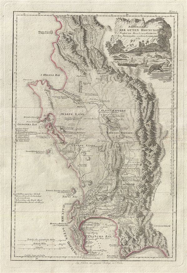
Das Vorgebirg der Guten Hofnung Verfasst von Herrn L.S. de la Rochette Neu Herausgegeben von Herrn. F.A. Schraembl.
1789 (dated) 20.5 x 14 in (52.07 x 35.56 cm)
1789 (dated) 20.5 x 14 in (52.07 x 35.56 cm)
Description
An attractive example of Louis Stanislas d'Arcy Delarochette's important 1789 map of the Cape of Good Hope, South Africa. The map covers from the fictional Klipping Island and St. Helena Bay south as far as False Bay (Valsbaai), Cape Hangklip, and Cape Peninsula, and eastward to the Drakenstein Mountains. This map was first issued by Faden in 1782, the present example being a 1789 reissue by the Austrian publisher, F.A. Schraembl. This beautifully engraved map features relief pictorially and names various Kraals (villages), fountains, river crossings and even the names of some early Dutch settlers. There are numerous depth soundings, in fathoms, in False Bay, Tsable Bay, and Saldanha Bay. The Cape Town settlement is noted as is the notorious prison, Robben Island. A fascinating title cartouche in the upper right quadrant depicts europeans fighting miniature elephants with spears – a nice idea but not advisable with a real elephant. Unlike most maps this was published as a broadside by both Faden and Schraembl.
CartographerS
Louis Stanislaw d'Arcy Delarochette (1731 - 1802) was a British cartographer and engraver active in London, England in the late 18th century. Delarochette produced numerous maps in conjunction with various other contemporary British cartographers including Faden, Jefferys, Laurie and Whittle, Arrowsmith, and Bowles. Delarochette is perhaps best known for his monumental eight sheet map of South America, which was used to settle numerous border disputes throughout the continent. He also produced an influential map of the Cape of Good Hope, a fine map of the West Indies, and worked with Sayer and Kitchin on their A new map of North America wherein the British Dominions in the continent of North America, and on the islands of the West Indies, are carefully laid down from all the surveys, hitherto made... More by this mapmaker...
Franz Anton Schrämbl (Schraembl; 1751 - December 13, 1803) was a Vienna-based cartographer working in the later part of the 18th century. Schrämbl was born in Vienna. He became director of the normal school in Troppau but soon quit to set up a bookshop in Vienna. In 1787, with fellow Austrian Franz Johann Joseph von Reilly (1766 - 1820), he founded a publishing firm. He began his great work, the Allgemeiner Grosser Atlas, in the same year. This ambitious large format atlas was to be based upon only the most up-to-date cartographic information available, among them cartographers J. B. B. D'Anville (1697 - 1782) and James Rennel (1742 - 1830), and explorers such as James Cook (1728 - 1779), Charles Roberts (1739 - 1825), and others. The atlas was published in 1800 and became the first Austrian commercial world atlas. The work experienced minimal circulation, possibly due to its high cost. The low sales nearly drove Schrämbl into insolvency, but he recovered through diversification into literature and art books. When Franz Anton died in 1803, his widow Johanna and her brother, the engraver Karl Robert Schindelmayer (1769 - 1839), assumed control of the firm. In 1825, his son, Eduard Schrämbl, took over. Learn More...
Condition
Good condition. Overall toning. Extremely wide margins. Some wear horizontally across center - see image.
References
Tooley, R.V., Collectors's Guide to Maps of the African Continent and Southern Africa, p. 42, pl.30. Phillips, P.L. (Atlases) 694-53. Norwich, O.I., Norwich's Maps of Africa: An Illustrated and Annotated Cartobibliography, 225. Schrire, D. The Cape of Good Hope 1782-1842, 5.