This item has been sold, but you can get on the Waitlist to be notified if another example becomes available, or purchase a digital scan.
1928 Admiralty Nautical Chart of Maritime Map of the Malacca Strait
CapeRachadoSingapore-admiralty-1928$875.00

Title
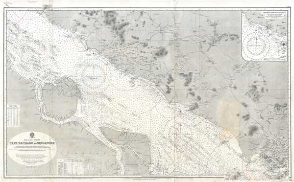
Malacca Strait Cape Rachado to Singapore.
1928 (dated) 28 x 44.5 in (71.12 x 113.03 cm) 1 : 292500
1928 (dated) 28 x 44.5 in (71.12 x 113.03 cm) 1 : 292500
Description
This is a 1928 British Admiralty nautical chart or maritime map of the Malacca Strait. The map depicts the region from Sumatra to Singapore Island and from Malaysia to Great Karimun Island (Pulo Karimun). A unique piece, numerous manuscript notations and updates have been added to this chart. A paste-down has been placed near the in the lower right quadrant, creating manuscript updates to the coastline and illustrating several rivers, one of which stretches a decent distance inland. Manuscript half-circles have been added in the strait itself, most likely to depict the distance out into the strait different beacons are discernable by a passing mariner. Not all the beacons feature this notation, creating the presumption that whoever created these notations may have only found certain beacons to be important when they were transiting the strait.
A chart full of detail, myriad depth soundings are noted throughout the strait. Several islands along the length of the strait are labeled, along with numerous locations along the Malaysian (Malay or Malaccan) coastline. Beacons are noted by yellow dots and inland topographical features are shown. Singapore Island is illustrated in detail, with numerous rivers, mountains, and beacons noted. The city of Singapore is labeled, as is Johore Bahru.
The Singapore Strategy
As this map was being printed, Singapore became central to the Singapore Strategy, a naval defense policy instituted by the British Empire between 1919 and 1941. Following World War I (1914 – 1918), it became apparent that the Royal Navy was facing challenges to its long established supremacy by the rising naval forces of the United States and Imperial Japan. While the growing U.S. Navy, being a strong ally, was not a serious cause of concern, it quickly became apparent that the Imperial Japanese naval buildup would clash with British interests in the Far East.
The British determined to establish a 'Gibraltar of the East,' zoning in on Singapore for its exceptionally strategic position. Starting work in 1919, the British began a series of extensive improvements to the port as an expense of some 500,000 GBP. Completed over the subsequent 20 years, Singapore was outfitted with largest dry dock in the world, the third largest wet dock, and enough fuel tanks to support the entire Royal Navy for six months. The island's defenses also included an enormous Royal Air Force base and mounted 15-inch stationary guns. Despite what appeared to be highly defensible position, when hostilities finally broke out between the British Empire and Imperial Japan, in 1942, Singapore fell to Japanese invaders after just 15 days of fighting, an event described by Prime Minister Winston Churchill as the 'worst disaster and largest capitulation in British history.'
This chart was engraved by Davies and Company and published by the Admiralty in 1928.
Cartographer
The British Admiralty Office (1795 - Present) or the United Kingdom Hydrographic Office refers to the Branch of the English government that is responsible for the command of the British Navy. In 1795 King George III created the United Kingdom Hydrographic Office, known in short as the U.K.H.O., to provide top notch nautical charts to the vast Royal Navy. Prior the founding of the Admiralty the surveying and creation of nautical charts was primarily a commercial venture wherein the cartographer himself, more of than not, actually financed the printing of his own material. The great navigator Cook himself is known to have scrambled for funds to publish his own seminal charts - the most important and advanced of the period. The system of privately funded nautical mapping and publishing left vast portions of the world uncharted and many excellent charts unpublished. King George III, responding significant loss in trade revenue related to shipwrecks and delay due to poor charts, recognized the need for an institutionalized government sponsored cartographic agency - the Admiralty. The first head of the Admiralty, a position known as Hydrographer, was the important cartographer Alexander Dalrymple. Dalrymple started by organizing and cataloging obtainable charts before initiating the laborious process of updating them and filling in the blanks. The first official Admiralty Chart appeared in 1800 and detailed Quiberon Bay in Brittany. By 1808 the position of Hydrographer fell to Captain Thomas Hurd. Hurd advocated the sale of Admiralty charts to the general public and, by the time he retired in 1829, had issued and published some 736 charts. Stewardship of the organization then passed to Rear Admiral Sir Francis Beaufort. It was under Beaufort's administration that the Admiralty truly developed as a "chart making" as opposed to a "chart cataloging" institution. Beaufort held his post from 1829 to 1854. In his 25 years at the Admiralty Beaufort created nearly 1500 new charts and sponsored countless surveying and scientific expeditions - including the 1831 to 1836 voyage of the H.M.S. Beagle. By 1855 the Admiralty's chart catalog listed some 1,981 charts. More by this mapmaker...
Condition
Very good. Even overall toning. Blank on verso.