This item has been sold, but you can get on the Waitlist to be notified if another example becomes available, or purchase a digital scan.
1949 Thomas Brothers Map of Carmel-by-the-Sea, California
Carmel-thomasbros-1949$450.00


Title
Thomas Bros. Map of Carmel-by-the-Sea, Monterey County, California.
1949 (undated) 31.25 x 43 in (79.375 x 109.22 cm) 1 : 2500
1949 (undated) 31.25 x 43 in (79.375 x 109.22 cm) 1 : 2500
Description
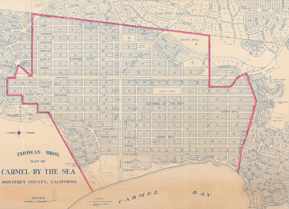
A scarce large-scale c. 1949 Thomas Brothers map of Carmel-by-the-Sea on the Monterey Peninsula on California's Central Coast. By this time, Carmel and the Monterey Peninsula had been firmly established as a seaside haven for artists, writers, and other bohemians. This map is a significant enlargement fo the central portion of a smaller Thomas map, with red highlighting of the central district - likely intended for urban management.
The historic Mission San Carlos Borroméo de Carmelo is at right. At this time, it was undergoing major renovations, having fallen into disuse, and become dilapidated in the 19th century. It was restored over many years by local craftsman John 'Harry' Downie, who received honors from the Pope for his efforts. The three neighborhoods just beyond city limits are Carmel Woods, Hatton Fields, and Carmel Point (here as 'Add'n No. 7'). These unincorporated communities were built in the 1920s to accommodate the rapidly growing population of Carmel. Further north along the coast, just beyond the scope of this map, is the famed Pebble Beach Golf Links.
A Closer Look
Oriented towards the east, this map indicates street names, property lines (including city-owned property), and block numbers throughout. Aside from the historic center of the town inland (east) from the coast, numerous later additions are also noted as such. Local landmarks the Forest Theater and Sunset School (now Sunset Center) are labeled, reflecting the city's character as a center for the arts.The historic Mission San Carlos Borroméo de Carmelo is at right. At this time, it was undergoing major renovations, having fallen into disuse, and become dilapidated in the 19th century. It was restored over many years by local craftsman John 'Harry' Downie, who received honors from the Pope for his efforts. The three neighborhoods just beyond city limits are Carmel Woods, Hatton Fields, and Carmel Point (here as 'Add'n No. 7'). These unincorporated communities were built in the 1920s to accommodate the rapidly growing population of Carmel. Further north along the coast, just beyond the scope of this map, is the famed Pebble Beach Golf Links.
Publication History and Census
This map was produced around the year 1949 by Thomas Brothers. It resembles but differs from other cataloged examples of Thomas Brothers' maps of Carmel-by-the-Sea (Rumsey 0994.041, OCLC 967942590, 123082192), most notably in its large size. The only known example closely resembling the current one was used as an Enumeration District Map for the 1950 Census (National Archives ID 7634596). There are no other known examples of this map.Cartographer
Thomas Brothers (1915 - 1999) was founded by George Copleland Thomas and his two brothers in Oakland in 1915. Operating from a street corner in Hollywood, Copeland started his business by selling maps to movie stars' homes. From this, Thomas created a 'map book' / guide book institution, while carrying most of the day-to-day operating information around in his head. After George Thomas passed away in 1955, his widow hired Warren Wilson, an attorney, to straighten out the company's affairs. When it became clear that none of Thomas's heirs were interested in continuing the business, it was offered for sale. Wilson and accountant Tom Tripodic jointly purchased the company and decided to move in a new direction while 'maintaining the Thomas Brothers' tradition.' They moved the company headquarters from San Francisco to Irvine, California. The company was purchased by Rand McNally in 1999 who laid off many of Thomas Brothers' most skilled cartographers and employees in 2003 and officially closed all California operations in 2009. More by this mapmaker...
Condition
Good. Uneven toning. Some edge tears repaired and reinforce on verso. Area of reinstatement bottom center.