
This item below is out of stock, but another example (left) is available. To view the available item, click "Details."
Details
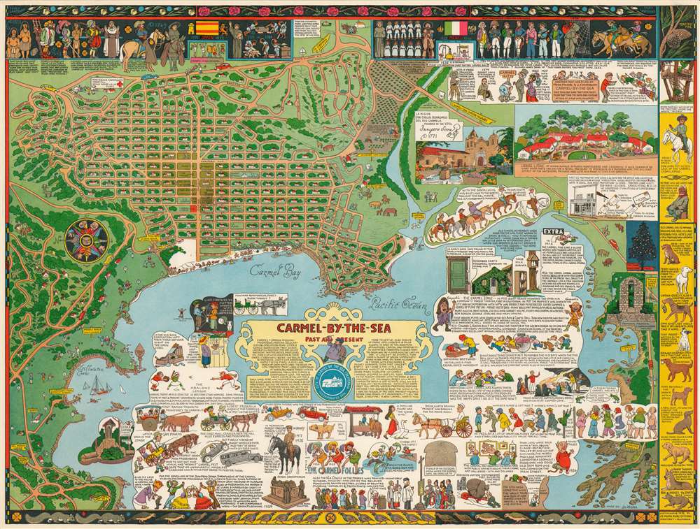
1942 Jo Mora Pictorial Map of Carmel-by-the-Sea, California
$1,100.00
1942 Jo Mora Pictorial Map of Carmel-by-the-Sea, California
CarmelbytheSea-mora-1942$475.00

Title
Carmel-by-the-Sea Past and Present.
1942 (dated) 18.75 x 24.75 in (47.625 x 62.865 cm)
1942 (dated) 18.75 x 24.75 in (47.625 x 62.865 cm)
Description
A beautiful example of the scarce 1942 Jo Mora pictorial map of Carmel, California. Located on the southern edge of the Monterey Peninsula, Carmel-by-the-Sea, is widely regarded as one of California's most beautiful beach-front communities. The map is oriented to the East, with Carmel at top and Carmel Bay at the bottom. The Carmel as presented here is very similar to modern-day Carmel, with the street layout clearly recognizable. Throughout, as was Mora's style, the map is rich with pictorial vignettes and other elements illustrating local history, humor, and folklore. Even the canines of Carmel have their place, with 10 famous dogs illustrated along the right border. This map is generally considered to be among the finest of Mora's map pieces.
20th Century Pictorial Cartography
Pictorial qualities have been common in cartography from at least from the 16th century, when publishers like Braun and Hogenberg incorporated view-like qualities and other pictorial elements into their famous city plans. Braun and Hogenberg, and similar cartographers, issued their town books to express, not necessarily the geography their subjects, but rather the 'essence' of the town/city. As mathematics and surveying principles became more advanced, travel increased, and the ability to translate 2-dimensional cartographic perspectives into an understanding of the actual world became commonplace, maps themselves transformed. This trend is a recognizable progression that evolved from the 17th to the 19th centuries. By the late 19th century most maps had become geographical tools that illustrated the region cartographically, but failed in the original raison d'être as expressed by Braun and Hogenberg, to illustrate a place's 'essence'. So, where a city map of 19th century Paris might provide a completely navigable presentation of the city, one could glean almost nothing of Paris' character from it. In the late 18th century, the first modern 'pictorial' style maps developed. These maps, like Tomas Lopez's 1788 map of Seville, attempted to provide both cartographic accuracy and pictorial elements that might convey the character of the city. In that case, Lopez incorporated pictorial vignettes to illustrate important buildings and monuments. This style became increasingly commonly throughout the 19th century and early 20th centuries, particularly for centers of commerce like London, Paris, and Rome, where they are often mass produced and referred to as 'monumental' maps. The style further evolved in the early to mid-20th century, when revolutionary cartographers and illustrators like MacDonald Gill, Jo Mora, Frank Dorn, Ernest Dudley Chase, and many others, combined vignette style illustrations, modern printing techniques, inspiration from Japanese printmaking and manga, and from clever satirical cartographers/artists like Fred Rose, to produce maps that once again focused on revealing the essence a place, usually, but not always, at the sacrifice of cartographic precision.Publication History and Census
This map was drawn by Jo More and published by Jo Mora Publications of Monterey, California, in 1942. The map was popular and there are a few variants in terms of color. There were also black and white issues.]. Some have a note on the bottom with a price '50c with tube'. The OCLC notes 5 examples and the map appears from time to time on the private market.Cartographer
Joseph 'Jo' Jancito Mora (October 22, 1876 – October 10, 1947) was an Uruguayan born artist active in California during the first half of the 20th century. Mora immigrated to California as a young man. He studied art in Boston and, after graduating, worked there briefly before relocating to California. In cartographic circles Mora is known for pioneering the 20th century pictorial map. In a series he referred to as his 'cartes,' published between in 1926 and 1942, Mora developed a pictorial style that combined cartography with colorful cartoonish image of local figures, folklore, history, and natural wonders. His earliest maps were commissioned by the Hotel Del Monte and included California's Playground and The Seventeen Mile Drive. As he matured as a cartographer, his work became increasingly dense, often packed with tiny figures, each expressive of some aspect of regional life. Mora, often called the 'Renaissance man of the West' also worked as an illustrator, muralist, sculptor, photographer, and writer. His masterpiece is considered to be the Father Serra Cenotaph, a bronze and marble sculpture at the Memorial Chapel in El Carmelo Mission, Carmel, California. His map work included Monterey Penninsula (1927), and Seventeen Mile Drive (1927), California (1927), Grand Canyon (1931), Yosemite (1931), Yellowstone (1936), Carmel-By-The-Sea (1942), California (1945) (large and small versions), Map of Los Angeles (1942), among others. More by this mapmaker...
Condition
Very good. Slight edge wear.
References
OCLC 953572376. Rumsey 10021.000.