This item has been sold, but you can get on the Waitlist to be notified if another example becomes available, or purchase a digital scan.
1746 Herman Moll Map of Carolina
CarolinabyMoll-moll-1746$315.00

Title
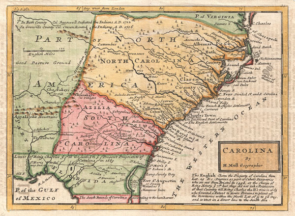
Carolina by H. Moll Geographer.
1746 (undated) 8 x 11 in (20.32 x 27.94 cm)
1746 (undated) 8 x 11 in (20.32 x 27.94 cm)
Description
A small but significant 1729 map of Carolina by Herman Moll. This map covers from the mouth of the Chesapeake to St. Augustine and from the Atlantic westward to the mouth of the Apalache River, encompassing the entire territory defined by the Carolina Grant of 1663 as well as additional territory in modern day Georgia and Florida added in a later revised grant. Moll notes the principal roadways along the coast as well as many important trade routes leading westward into American Indian lands. Along the coastline several islands are identified for the first time in a printed map. Also noted are various battles including the 1705 destruction of the mission of St. Maria de Palaxy along the Gulf Coast, Colonel Barnwell's 1712 defeat of the Tuscarora (the first major military victory by Carolina settlers over an Indian nation), and Colonel Craven's 1716 route of the Yamasee.
More importantly (and interestingly) this is also one of the few maps to depict the fanciful utopian colony of Azilia in modern day Georgia. In 1717, sixteen years before Georgia was founded, Sir Robert Montgomery proposed the creation of the Margravate of Azilia. The plan, laid out on a bold scale, would generate a buffer zone between the Carolina Colony and French, Spanish, and Indian incursions from the west. The colony never materialized largely due to lack of interest, but Moll's inclusion of it here marks this as one of the earlier examples of this map. In the later editions Azilia is replaced by 'Georgia.'
This map was issued in a number of different states from 1729 to about 1750. This particular example was issued in volume three of Samuel Simpson's The Agreeable Historian published in London in the 1740s.
Cartographer
Herman Moll (1654 - 1732) was an important 18th century map publisher and engraver based in London and Holland. Moll's origins are disputed with some suggesting he was born in the Netherlands and others Germany - the Moll name was common in both countries during this period. Most likely Moll was a German from Bremen, as his will, friends, and contemporaries suggest. What is known for certain is that he moved to London in 1678, possibly fleeing the Scanian War, where he worked as an engraver for Moses Pitt and other London map publishers. Around the turn of the century, Moll set up his own shop where he produced a large corpus of work known for its high quality and decorative flair. As a new émigré to England, Moll made himself more English than the English, and through his cartography proved a fierce advocate for his adopted nation. Most of Moll's early maps were issued as loose sheets that would be bound to order, however, he did publish several important atlases late in his career. Moll is said to have made the bold claim that without a doubt "California is an Island" and that he "had in [his] office mariners who have sailed round it." While California may not be an island (yet), it is true that moll had talent for attracting interesting friends and acquaintances. He frequented London's first stock exchange, Jonathan's Coffeehouse at Number 20 Exchange Alley, Cornhill. At the time Jonathan's was known as "a place of very considerable concourse for Merchants, sea faring Men and other traders" (Erleigh, The Viscount, The South Sea Bubble, Manchester: Peter Davies, Ltd., 1933, 21). Eventually this activity attracted the interest of stock brokers, who inspired by sailor's tales, sponsored the ill-fated South Sea Company, the world's first stock bubble. Moll's close circle, mostly from the Coffee House, included scientist Robert Hooke, the writers Daniel Defoe (Robinson Crusoe) and Jonathan Swift (Gulliver's Travels), the pirates William Dampier, William Hacke and Woodes Rogers, and the archeologist William Stukeley. Herman Moll's work was highly regarded for its decorative beauty and was pirated, most notably by the Irish publisher George Grierson, both in his lifetime and after his 1732 death at St. Clement Danes, London. More by this mapmaker...
Source
Simpson, S., The Agreeable Historian, (London) 1746.
Condition
Very good. Even overall toning. Blank on verso. Minor transferrence from adjacent page.
References
Rumsey 5580.051. Cumming, W. P., The Southeast in Early Maps, #206-E. Phillips (America) p. 612. Karpinski, L. C., Early Map of Carolina and Adjoining Regions from the Collection of Henry P. Kendall, 28. Williams, G. W., and Johnson, A. S., Tar Hell Maps: Colony and State, 1590 - 1995, #8.