
This item below is out of stock, but another example (left) is available. To view the available item, click "Details."
Details
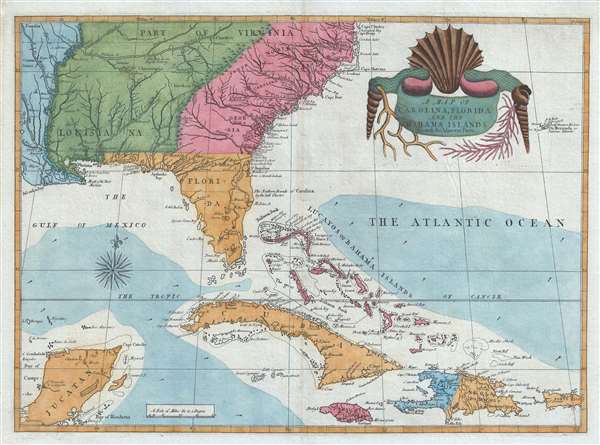
1743 / 1771 Catesby Map of the American Southeast: Florida, Georgia and the Bahamas
1743 (undated) $21,000.00
1743 / 71 Catesby Map of the American Southeast: Carolina, Florida…
CarolinaFlorida-catesby-1743$4,750.00

Title
A Map of Carolina, Florida and the Bahama Islands with the Adjacent Parts.
1771 (undated) 17.5 x 24.5 in (44.45 x 62.23 cm) 1 : 5385600
1771 (undated) 17.5 x 24.5 in (44.45 x 62.23 cm) 1 : 5385600
Description
A fine example of Mark Catesby’s rare 1743 / 1771 map of the southeastern parts of North America. This map is considered one of the finest maps of the colonial era American southeast. The map covers from the Mississippi River and from Cape Charles and Cape Henry to Jamaica, including all of North Carolina, South Carolina, Georgia, Florida, Louisiana, Cuba, Hispaniola, the Bahamas, Porto Rico, and parts of the Yucatan. Among other features, the map is notable for its remarkable cartouche design, which includes shells, corals, and seaweeds indigenous to the Americas. The map is furthermore an important reference for early forts, Indian tribes, English factories, and more in the southeast. The river systems of Georgia and Carolina are particularly impressive in their detail.
Catesby’s Sources
Cartographically the map is derived primary from the 1733 Henry Popple wall map A Map of the British Empire in America with the French and Spanish Settlements. He also draws on John Barnwell’s map of 1722, details from which are otherwise known only in manuscript. The map was prepared for editions of Mark Catesby’s Natural History of Carolina, Florida and the Bahama Islands. Considered to be the first illustrated natural history to focus on the flora and fauna of the Americas. The map was intended to contextualize the plants and animals described throughout the work.Complicated Publication History
This map was most likely first engraved around 1737, which makes Catesby’s use of the Popple map of 1733 an obvious choice. It was intended for publication with his book, as previously noted, sometimes appearing in volume 1, other times in volume 2. This is because the map was not ready when volume 1 was initially published, in 1731, but was ready when volume 2 was published in 1743. In subsequent printings, it was prefixed appropriately to Volume 1. Note, map historian William R. Cummings, in his important cartobibliography The Southeast in Early Maps incorrectly dates it to 1731 or 1734, citing the publication of the book.Engraved by Catesby – Rawlinson Connection
There is good evidence that Catesby himself engraved the map. Pearce S. Grove, writing in The Map Collector 56, describes the 1986 discovery of an unpublished copperplate by Virginian antiquary Richard Rawlinson at Oxford’s Bodleian Library. On that large plate the present map forms an inset. Grove argues convincingly that it was Catesby who engraved the maps (and thus this one as well) for Rawlinson.States and Editions
This map appears in a single edition of which there are three sub-states determined by the map’s color scheme and paper, with the printed content remaining unchanged. In the first sub-state, which appeared in 1743, the territory on both sides of the Mississippi River is green, as it was then under French control. In 1771, following the French and Indian War (1754 – 1763) the map was altered to reflect the 1763 Treaty of Paris in which all the lands east of the Mississippi came under British control, and lands to the west were colored blue to reflect Spanish control – present example. A third state, issued in 1815, appears on J. Whatman watermarked paper.Cartographer
Mark Catesby (March 24, 1683 - December 23, 1749) was a British artist, scientist, and explorer active in the early to middle parts of the 18th century. He was born at Castle Hedingham, Essex, England, the son of a gentleman farmer and a prominent local politician. John Ray, a famed English naturalist and family, friend inspired Catesby to study natural history. When his father died, in 1712, he accompanied his sister, Elizabeth and her husband William Cooke, a member of the Virginia colony governor’s council, to Virginia. This was his first voyage to the Americas, where he remained for the subsequent 7 years, traveling through Appalachia and to some of the West India Islands, including Jamaica. During his travels he produced meticulous illustrations of the flora and fauna he encountered. On his return to London, the Royal Academy, then headed by Sir Isaac Newton, were so impressed with his work that they raised funds for a second voyage. Catesby returned to the America’s in 1722, arriving in Charleston. In the subsequent 4 years, he traveled throughout the Carolina, Florida, and the Bahamas, observing animal and plant life, and laying the groundwork for his seminal work, The Natural History of Carolina, Florida and the Bahama Islands, considered to be the first fully-illustrated natural history of North America. His work was highly influential, inspiring a new generation of natural historians, including Carl Linnaeus (1707 - 1778) and John James Audubon (1785 - 1851). Catesby died at his home in London where he was buried in the St. Luke Old Street churchyard, aged 66. More by this mapmaker...
Source
Catesby, M., Natural History of Carolina, Florida and the Bahama Islands (London) 1771.
Condition
Very good.
References
OCLC 20309168. Cumming, W., The Southeast in Early Maps, #210, page 25. Schwartz, S. and Ehrenberg, R., The Mapping of America, p.151-2.