This item has been sold, but you can get on the Waitlist to be notified if another example becomes available, or purchase a digital scan.
1768 Vaugondy Map of California and Alaska
CartedeLaCalifornie-vaugondy-1768$189.50

Title
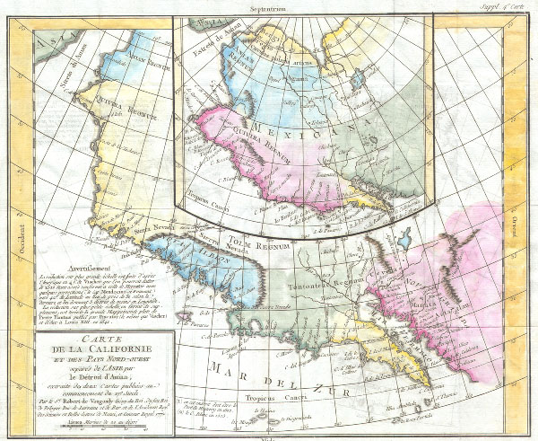
Carte de la Caliofrnie et des pays Nord-ouest separes de l’Asie par Le Detroit d’Anian, extradite de dus Cartes publiees au commencement du 17e Siecle.
1768 11.5 x 15 in (29.21 x 38.1 cm)
1768 11.5 x 15 in (29.21 x 38.1 cm)
Description
This is the important Denis Diderot / Didier Robert De Vaugondy map of California. Two maps, the larger depicts the Northwestern part of North America from Anian (Alaska) to Cabo San Lucas. The smaller central map is a larger perspective of the entire region. Both maps are based on the early work of Visscher between 1612 and 1641. The smaller map shows the region free of ice – suggesting the possibility of a Northwest Passage. Lists prominently the supposed American Indian kingdoms of Anian Regnum, Quivira Regnum, the Sierra Nevada, Nova Albion, Tontonteac Regnum, Tolm Regnum. Also includes many costal place names, some of which are recognizable, and some of which are recognizable (C. de San Francisco, Mendocino, Cape Fortuna, etc. ) and other which are entirely mythical. This work is part of the 10 map supplement to Diderot's encylopidia, much of which is dedicated to the Northwestern part of the American continent.
Cartographer
Robert de Vaugondy (fl. c. 1716 - 1786) was French may publishing from run by brothers Gilles (1688 - 1766) and Didier (c. 1723 - 1786) Robert de Vaugondy. They were map publishers, engravers, and cartographers active in Paris during the mid-18th century. The father and son team were the inheritors to the important Nicolas Sanson (1600 - 1667) cartographic firm whose stock supplied much of their initial material. Graduating from Sanson's maps, Gilles, and more particularly Didier, began to produce their own substantial corpus. The Vaugondys were well-respected for the detail and accuracy of their maps, for which they capitalized on the resources of 18th-century Paris to compile the most accurate and fantasy-free maps possible. The Vaugondys compiled each map based on their own geographic knowledge, scholarly research, journals of contemporary explorers and missionaries, and direct astronomical observation. Moreover, unlike many cartographers of this period, they took pains to reference their sources. Nevertheless, even in 18th-century Paris, geographical knowledge was limited - especially regarding those unexplored portions of the world, including the poles, the Pacific Northwest of America, and the interiors of Africa, Australia, and South America. In these areas, the Vaugondys, like their rivals De L'Isle and Buache, must be considered speculative or positivist geographers. Speculative geography was a genre of mapmaking that evolved in Europe, particularly Paris, in the middle to late 18th century. Cartographers in this genre would fill in unknown lands with theories based on their knowledge of cartography, personal geographical theories, and often dubious primary source material gathered by explorers. This approach, which attempted to use the known to validate the unknown, naturally engendered rivalries. Vaugondy's feuds with other cartographers, most specifically Phillipe Buache, resulted in numerous conflicting papers presented before the Academie des Sciences, of which both were members. The era of speculative cartography effectively ended with the late 18th-century explorations of Captain Cook, Jean Francois de Galaup de La Perouse, and George Vancouver. After Didier died, his maps were acquired by Jean-Baptiste Fortin, who in 1787 sold them to Charles-François Delamarche (1740 - 1817). While Delamarche prospered from the Vaugondy maps, he defrauded Vaugondy's window Marie Louise Rosalie Dangy of her rightful inheritance and may even have killed her. More by this mapmaker...
Condition
Very Good. Minor transference. Contemporary color. Wide clean margins. Original platemark. Blank on verso.
References
Wheat 159; Wagner 632; Pedley 473.