This item has been sold, but you can get on the Waitlist to be notified if another example becomes available, or purchase a digital scan.
1752 Anville Map of the Gulf Coast and Mississippi River Delta
CartedelaLouisiane-anville-1752-3$700.00

Title
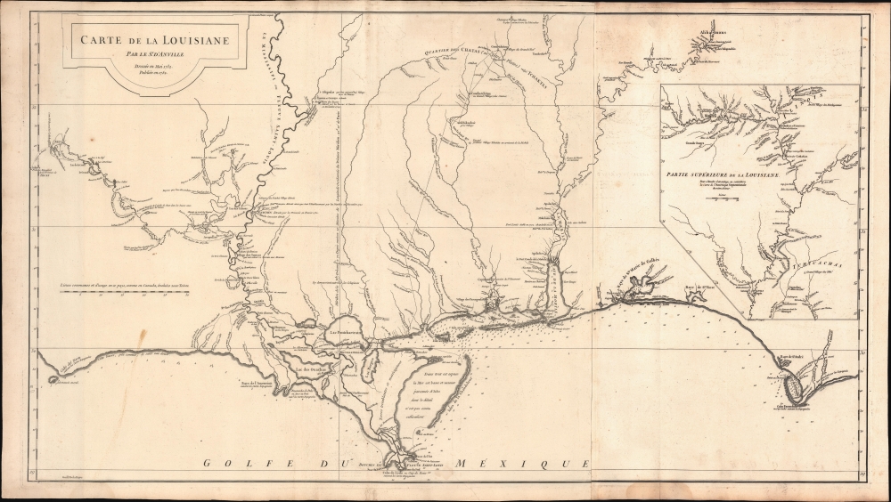
Carte de la Louisiane.
1752 (dated) 21 x 37 in (53.34 x 93.98 cm) 1 : 830000
1752 (dated) 21 x 37 in (53.34 x 93.98 cm) 1 : 830000
Description
A lovely example of the important 1732/52 map of the Gulf Coast and lower Mississippi River Valley by Jean Baptiste Bourguignon d'Anville. The map is significant as the largest and most comprehensive map of the Gulf littoral to appear during the French period of Louisiana.
A Closer Look
D'Anville's map covers from Sabine Pass (Cabo del Norte), Texas, past the Mississippi River Delta, Mobile Bay, and Pensacola Bay, to Saint Joseph Bay (Baye de St. Joseph) and Cabo Escondido (Cape San Blas), Florida. The map extends northwards along the Mississippi River as far as, roughly, Lake Providence and northwards along the Alabama River (Riviere des Alibamons) as far as Fort Toulouse (modern-day Wetumpka, Alabama). An inset in the upper right focuses on the upper Mississippi River Valley and includes much of the lower Missouri River as far as the Kansas River (Kansaz). Minimal topography is present as little was known, but the region's river courses, including the lower Mississippi, the Red, the Osage, and the lower Missouri, appear in some detail. Numerous depth soundings are indicated along the Gulf Coast and in the adjacent Bays.Valentin Devin
Cartographically, much of the coastal information presented here is derived from manuscript work compiled by French Royal Engineer Valentin Devin from 1720 through 1732. Devin's work was incorporated into this map, as well as into maps by competing French cartographers Philippe Buache, Nicholas Bellin, and Guillaume De L'Isle. Another Royal Engineer, Ignace François Broutin, is responsible for much of the inland cartography, particularly around Natchitoches and Natchez.Historical Context
Historically speaking, D'Anville drew this map following the 1730 French siege and subsequent destruction of the Grand Village of Natchez. The attack was a retaliatory move following the 1728 Natchez Massacre, in which 229 French colonists settled nearby at Fort Rosalie (depicted) were slain. The war ultimately dispersed the once-powerful Natchez Nation. Many of the Natchez diaspora were subsequently absorbed into the Creek and Chickasaw. The Grand Village of Natchez itself re-emerged as a European trading center on the Mississippi.A Detailed Mississippi Valley
D'Anville's map is most richly detailed along the Mississippi River, especially the lower Mississippi in the vicinity of New Orleans, on which the map is loosely centered. Numerous European and American Indian towns and villages, along with active and abandoned fortifications, are identified throughout. Some depth soundings are indicated in Lake Pontchartrain. The Chandeleur Sound is noted as having many little-known islands. The mouth of the Mississippi, with its complex network of channels, is, for the period, well mapped.The French-Mexican Frontier
The map extends westward along the Red River (Riviere Rouge) as far as Tecas (Texas), the limit of French dominion. Here, the French Fort of Natchitoches stands but seven leagues from the Spanish Presidio de San Miguel Arcangel de Linares de Adayes, identified as 'Adayes.' It is not without significance that D'Anville breaks the border of the map to include the Presidio, for just as it is outside the printed area of this map, it is also beyond the boundaries of French influence. The cartography for this region is extracted from Ignace François Broutin's map of 1722.The French-English Frontier
At the opposite extreme of the map is Fort Toulouse (For des Alibamons or Alabama Fort) at the conjunction of the Coosa and Tallapoosa Rivers, in the country of the Alibamons (from which the name Alabama is derived). The French established Fort Toulouse in 1717 as a bastion against English incursions. Records suggest that the Alabama Indians invited the French, who they perceived as the lesser of two evils, during the 1715-1717 Yamasee War. The Yamasee War was fought between English settlers in South Carolina and various American Indian Nations. The French abandoned Fort Toulouse in 1763.French and Indian Trade
Extending inland roughly from Lake Borgne (Chenaux) northward along various river systems, a dotted line representing an established trade route extends north to the large Choctaw villages of Coue-Tchitou and Concha-Tchitou, as well as several lesser villages. D'Anville identifies these lands as the 'Quartier des Chats (ou Tetes Plates) vulgo Tchaktas.'The Inset
The inset map in the upper right, although small compared to the rest of the map, offers an interesting perspective on the Upper Mississippi and Lower Missouri Rivers. Here, D'Anville has confused the Ohio and Wabash Rivers, presenting them as a single river - an error that D'Anville would correct in his later map Amerique Septentrionale.An Influence on the Louisiana Purchase?
Thomas Jefferson is known to have acquired seven maps by D'Anville in 1787, among which this map was almost certainly included. In a subsequent letter to Secretary of Treasury Albert Gallatin regarding a newly commissioned map of North America, Jefferson obliquely referenced this map when he suggested using D'Anville as a reference for the Lower Mississippi Basin. This map must also have been consulted by Meriwether Lewis in preparation for the historic Lewis and Clark Expedition up the Missouri River.Publication History
Though drawn in 1732 and not issued until 1752, twenty years later, D'Anville's Louisiane was among the best and most detailed available large format maps of this region until well into the early 19th century. The map was engraved by Guillaume de la Haye. It was issued in various made-to-order atlases and remained popular due to its accuracy for over fifty years.CartographerS
Jean Baptiste Bourguignon d'Anville (1697 - 1782) was perhaps the most important and prolific cartographer of the 18th century. D'Anville's passion for cartography manifested during his school years when he amused himself by composing maps for Latin texts. There is a preserved manuscript dating to 1712, Graecia Vetus, which may be his earliest surviving map - he was only 15 when he drew it. He would retain an interest in the cartography of antiquity throughout his long career and published numerous atlases to focusing on the ancient world. At twenty-two D'Anville, sponsored by the Duke of Orleans, was appointed Geographer to the King of France. As both a cartographer and a geographer, he instituted a reform in the general practice of cartography. Unlike most period cartographers, D'Anville did not rely exclusively on earlier maps to inform his work, rather he based his maps on intense study and research. His maps were thus the most accurate and comprehensive of his period - truly the first modern maps. Thomas Basset and Philip Porter write: "It was because of D'Anville's resolve to depict only those features which could be proven to be true that his maps are often said to represent a scientific reformation in cartography." (The Journal of African History, Vol. 32, No. 3 (1991), pp. 367-413). In 1754, when D'Anville turned 57 and had reached the height of his career, he was elected to the Academie des Inscriptions. Later, at 76, following the death of Philippe Buache, D'Anville was appointed to both of the coveted positions Buache held: Premier Geographe du Roi, and Adjoint-Geographer of the Academie des Sciences. During his long career D'Anville published some 211 maps as well as 78 treatises on geography. D'Anville's vast reference library, consisting of over 9000 volumes, was acquired by the French government in 1779 and became the basis of the Depot Geographique - though D'Anville retained physical possession his death in 1782. Remarkably almost all of D'Anville's maps were produced by his own hand. His published maps, most of which were engraved by Guillaume de la Haye, are known to be near exact reproductions of D'Anville' manuscripts. The borders as well as the decorative cartouche work present on many of his maps were produced by his brother Hubert-Francois Bourguignon Gravelot. The work of D'Anville thus marked a transitional point in the history of cartography and opened the way to the maps of English cartographers Cary, Thomson and Pinkerton in the early 19th century. More by this mapmaker...
Guillaume-Nicolas Delahaye (1725 - February 24, 1802) was the most prolific member of the Delahaye (De-La-Haye) family of engravers active in Paris throughout the 18th century. Given that the name, Delahaye literally translates to 'of the Hague' it can be assume they were French Huguenots who were forced to flee the Netherlands under threat of religious persecution. Born in Paris, he was the son of patriarch Jean-Baptiste Delahaye and brother to Jean-Baptistie-Henri Delahaye. It is said that his godfather, who held him at the baptismal font, was none other than the famous french cartographer Guillaume de L'Isle. The Delahaye family engraved for many of the great cartographers of 18th century Paris, including Jean-Baptiste Bourguignon d'Anville, Didier Robert de Vaugondy, Jean-Baptiste de Mannevillette, and Jean-Nicolas Buache, among others. He was awarded the public office Premier Graveur du Roi and worked on a series of maps illustrating the king's hunts around Versailles. Guillaume also worked with foreign cartographers such as Tomas Lopez of Madrid. Possibly Delahaye's most significant map is A Map of the Country between Albemarle Sound and Lake Erie prepared for the memories of Thomas Jefferson. He married in 1758. In total he engraved some 1200 maps. Delahaye died in Charenton. In 1792, his daughter, Antoinette Marie Delahaye (1773-1857), married the geographer Jean-Denis Barbie du Bocage. Learn More...
Condition
Very good. Minor centerfold repair lower margin. Minor discoloration lower left. Light dampstaining lower margins. Slight toning differentiation due to fold metric.
References
Rumsey 2603.037. Osmon, Rick, The Graves of the Golden Bear: Ancient Fortresses and Monuments of the Ohio, p. 27-29. Jackson, J., Flags Along the Coast: Charting the Gulf of Mexico, 1519-1759: a Reappraisal, p.94. Lowery #333. Phillips (Atlases) 571-35. Riley, Franklin Lafayette, Publications of the Mississippi Historical Society, Volume 6, p. 405. Halbert, H. S., Publications of the Mississippi Historical Society, Volume 3, p. 367-371. Taliaferro, H., Cartographic Sources in the Rosenberg Library, 141. Lowery, W., The Lowery Collection, 333.