This item has been sold, but you can get on the Waitlist to be notified if another example becomes available, or purchase a digital scan.
1720 Chatelain Chart of the Principles of Fort Construction
CarteFortifications-chatelain-1720$275.00

Title
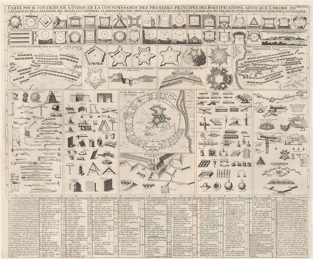
Carte pour contribuer a indiquer la connoissance des premiers principes des fortifications, ainsi que l'ordre de l'attaque, et de la defence des places, les campemens et dispositions des armées, les machines et instrumens de guerre, avec des remarques et des tables pour en faciliter la connoissance.
1720 (undated) 19.5 x 23.75 in (49.53 x 60.325 cm)
1720 (undated) 19.5 x 23.75 in (49.53 x 60.325 cm)
Description
This is a 1720 Henri Abraham Chatelain chart of fortification design and armament, created as an introduction to the principles of fortification. The first forty-one illustrations present elements of fort construction along with six different designs, one of which utilizes the local terrain to reinforce defenses. Below to the left is a diagram detailing the different parts of a fort in practice, revealing how the pieces work together. Plans illustrating the Battle of Landen and the Battle of Hochstet occupy space to the left and right. Diagrams illustrating hand weapons, offensive works, artillery, and defensive works occupy the middle third of the sheet, presenting the more active aspects of attack and defense.
Publication History and Census
This chart was published by Henri Abraham Chatelain and François L'Honoré in 1720 in the seventh volume of their Atlas historique, ou Nouvelle introduction à l'histoire, à la chronologie et à la géographie ancienne et moderne... titled Suplément a l'Atlas Historique contenant diverses pièces de Chronologie, de Genealogie, d'Historie, et d'autres Science qui avoient été omises dans les précédens Volumes. We note a single cataloged example of the separate map in OCLC which is part of the collection at the Klassik Stiftung Weimar / Herzogin Anna Amalia Bibliothek. The Suplément a l'Atlas Historique is well represented in institutional collections.Cartographer
Henri Abraham Chatelain (1684 - 1743) was a Huguenot pastor of Parisian origins. He lived consecutively in Paris, St. Martins, London (c. 1710), The Hague (c. 1721) and Amsterdam (c. 1728). He is best known as a Dutch cartographer and more specifically for his cartographic contribution in the seminal seven volume Atlas Historique, published in Amsterdam between 1705 and 1720. Innovative for its time, the Atlas Historique combined fine engraving and artwork with scholarly studies of geography, history, ethnology, heraldry, and cosmography. Some scholarship suggests that the Atlas Historique was not exclusively compiled by Henri Chatelain, as is commonly believed, but rather was a family enterprise involving Henri, his father Zacharie and his brother, also Zacharie. More by this mapmaker...
Source
Chatelain, H., Atlas historique, ou Nouvelle introduction à l'histoire, à la chronologie et à la géographie ancienne et moderne... (Amsterdam: L'Honoré et Chatelain) 1720.
Condition
Very good. Light wear along original fold lines. Light creasing.
References
OCLC 837674464.