
1946 Skacel Cartoon Map of Florida


This item has been sold.
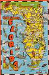
Bill Skacel's Cartoon Map of Florida.
Cartoons promote post-war Florida.
Choose a Collection:
- Digital Map Information
- Suitable for large format printing
- Full resolution TIFF file
- ICC color profile embedded
- Delivered instantly via download link
This Item
Enquire
Cartoons promote post-war Florida.
This is a 1946 Bill Skacel cartoon map of Florida. Cartoons appear throughout highlighting Florida attractions, including the winter quarters of Ringling Brothers, the Bok Singing Tower (which has a face here), and Daytona Speedway. An elderly gentleman marks St. Augustine, referencing its status as America's oldest city. Orange, lemon, and palm trees highlight Florida's semi-tropical climate, along with numerous women in bikinis and a mermaid! Key West is marked by a large key on wheels and Silver Springs appears as a large silver spring.Verso Content
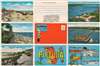
Five color photographs adorn the verso promoting St. Augustine, St. Petersburg, Daytona Beach, Pensacola, and Palm Beach. Pictures of Bradenton and Fort Myers appear as well, alongside illustrations of elephants and a fisherman.Publication History and Census
This map was created by Bill Skacell and copyrighted by the E. C. Kropp Company c. 1946. This map does not appear in OCLC, and we have not found any cataloged in institutional collections. It is rare on the private market, having appeared only a handful of times in the last decade.Condition
Very good. Light wear along original fold lines. Slight loss along original fold lines and at fold intersections. Text and printed images on verso.