
1950 Smith Pictorial Map of New Mexico

This item has been sold.
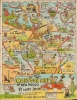
Cartoon Map of New Mexico. / New Mexico Land of Enchantment and Romance.
'This is God's Country Don't Drive Thru It Like Hell'.
- Digital Map Information
- Suitable for large format printing
- Full resolution TIFF file
- ICC color profile embedded
- Delivered instantly via download link
'This is God's Country Don't Drive Thru It Like Hell'.
A wildly amusing cartoon map of New Mexico, produced around 1950 by Larry Smith. Drawn in Smith's distinctive style, it features Native Americans, cowboys, gunfights, cactuses, and a mushroom cloud from the Trinity Test.A Closer Look
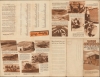
Coverage embraces the entire state, with highways and major roads are traced in red. Cities and towns are noted, often with accompanying illustrations, such as an artist painting a picture of a cactus at Taos. Drawings of Native Americans, cowboys (including Billy the Kid), skiers, and other figures appear throughout, along with geographical features such as Carlsbad Caverns. A figure holding a drink near El Paso and Juárez is almost certainly a reference to Prohibition, when American brewers and distillers moved across the border to continue operations, attracting regular cross-border customers. The site of the first test of the atom bomb (the Trinity Test) in July 1945 is depicted nearby. The verso includes a mileage chart between towns and cities in New Mexico, along with promotional text and photographs.Publication History and Census
This map was drawn and distributed by Larry Smith around 1950 for the New Mexico Department of Game and Fish. It is not known to exist in institutional collections and is scarce to the market. Smith also produced similar cartoon maps of Arizona and Michigan, which are equally scarce.Cartographer
Larry Smith (fl. c. 1935 - 1955), sometimes signing his works as 'Hillbilly Larry' was an artist and illustrator based in Ruidoso, New Mexico. His known works, including pictorial maps, comic strips, and postcards, are generally irreverent and highly stylized, employing characters drawn from Smith's surroundings (especially cowboys and Native Americans). Smith appears to have been a well-known and colorful character in Ruidoso and surrounding towns. He was a friend, mentor, and influence on Bill Mauldin (1921 - 2003), who became famous for his illustrations of Army life during World War II and won two Pulitzer Prizes for his editorial cartoons. The details of Smith's life are difficult to determine, in part because of the commonality of his name and in part because of his itinerant lifestyle, especially during the Depression years, but he appears to have lived in Ruidoso and Alamogordo, New Mexico at different points in his life. Further Details...
Condition
Very good. Wear along original folds. Slight loss at several fold junctions.