1725 Homann Map of the Caspian Sea and Kamchatka (as Yedso)
CaspianKamchatka-homann-1725$850.00
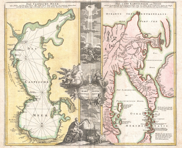

Title
Geographica Nova ex Oriente Gratiosissima, Duabus Tabulis Special. contenta, quarum Una Mare Caspium, Altera Kamtzadaliam, seu Terram Jedso.
1725 (undated) 20 x 23 in (50.8 x 58.42 cm)
1725 (undated) 20 x 23 in (50.8 x 58.42 cm)
Description
One of Homann's most interesting and influential maps, this 1725 map depicts the Caspian Sea and the Peninsula of Kamchatka. Essentially two maps in one, Homann here juxtaposes two opposite parts of Asia: the Capsian Sea, which forms part the western border of Asia and Europe, and the Peninsula of Kamchatka, the easternmost known point in continental Asia. While this combination may seem odd to us today, to the 18th century European, reared on the works of Marco Polo and steeped in the legends of wealth associated with the orient, it represented the legendary Silk Route across Asia as well as the eastern and western most claims of the expanding Russian Empire. During this period, both the Caspian Sea and Kamchatka were actively being explored by European powers eager to exploit the riches of Asia.
The left hand map, focusing on the Caspian Sea, marks a significant step forward in the mapping of this region, reflecting the 1719 - 1721 survey work of the Russian navy officer Karl van Verden. Verden's work, completed shortly before this map's publication was the most advanced mapping of the Caspian sea to date, offering a new perspective on the region and opening the navigational possibility of the world's largest lake.
The right hand map depicts Kamchatka. Though only tentatively explored at this point, Russian forces under Vladimir Alassov took control of the peninsula in 1697. In the process they stumbled upon a small colony of Japanese shipwreck survivors, a discovery that lead the Russians to speculate that Kamchatka was one and the same with Yedso (Jedo or modern day Hokkaido), the northernmost part of Japan. Homann's timely map of the region thus had a significant impact on subsequent cartography of the region. Most importantly Homann's map influenced Engelbert Kaempfer's 1727 History of Japan which laid the ground work for European cartographic representations of Japan for the next 50 to 60 years. Subsequent maps of Japan would incorporate the mythical island of Matsumai (shown here as Matmanska) into a small archipelago joining Japan to Kamchatka - thus placing part of the prized Japanese island chain in the sphere of Russian, hence European, influence.
East of Kamchatka there appear two large bodies of land. These mythical landmasses reflect speculation associated with the connections between Northeastern Asia and Northwestern America. Many early maps incorporated these islands, often called Compagnie Land, Terre de Compagnie, Gamaland, or just Gama. Though not labeled as such on this map, there is no doubt this land is what Homann is attempting to represent. Compagnie was supposedly discovered by the mysterious sailor Jean de Gama in the 17th century. Most likely this territory is, like Muller's Peninsula, merely a misinterpretation of numerous sightings of the various Aleutian Islands.
The two primary panels of this map are separated by an unusual band of allegorical cartouche work. From on high the sun gazes down upon the lands of men and gods - much as the cartographer might have imagined himself looking down upon the world. Cherubs, angels, and cosmic figures hold aloft the instruments of cartography. At the base of the cartouche a man sits next to a globe, his mapping tools at hand. The globe itself is set to Asia with both the Caspian Sea and Kamchatka set recognizably in context. One of the most interesting elements of this cartouche is the small map of Japan being held by a child in the lower right. Though tiny and a seeming minor element, this little map is actually the first of a serious of important representations of Japan in which the Noto Peninsula is turned westward. This cartographic convention did not begin to appear in actual maps until Bellin's 1736 mapping of Japan.
All in all a highly significant map of two fascinating parts of Asia and an important addition to any serious collection focusing on the early mapping of either the Caspian Sea or Japan. Published in 1725 by J. B. Homann of Nurembourg, Germany.
CartographerS
Johann Baptist Homann (March 20, 1664 - July 1, 1724) was the most prominent and prolific map publisher of the 18th century. Homann was born in Oberkammlach, a small town near Kammlach, Bavaria, Germany. As a young man, Homann studied in a Jesuit school and nursed ambitions of becoming a Dominican priest. Nonetheless, he converted to Protestantism in 1687, when he was 23. It is not clear where he mastered engraving, but we believe it may have been in Amsterdam. Homann's earliest work we have identified is about 1689, and already exhibits a high degree of mastery. Around 1691, Homann moved to Nuremberg and registered as a notary. By this time, he was already making maps, and very good ones at that. He produced a map of the environs of Nürnberg in 1691/92, which suggests he was already a master engraver. Around 1693, Homann briefly relocated to Vienna, where he lived and studied printing and copper plate engraving until 1695. Until 1702, he worked in Nuremberg in the map trade under Jacob von Sandrart (1630 - 1708) and then David Funck (1642 - 1709). Afterward, he returned to Nuremberg, where, in 1702, he founded the commercial publishing firm that would bear his name. In the next five years, Homann produced hundreds of maps and developed a distinctive style characterized by heavy, detailed engraving, elaborate allegorical cartouche work, and vivid hand color. Due to the lower cost of printing in Germany, the Homann firm could undercut the dominant French and Dutch publishing houses while matching their diversity and quality. Despite copious output, Homann did not release his first major atlas until the 33-map Neuer Atlas of 1707, followed by a 60-map edition of 1710. By 1715, Homann's rising star caught the attention of the Holy Roman Emperor Charles VI, who appointed him Imperial Cartographer. In the same year, he was also appointed a member of the Royal Academy of Sciences in Berlin. Homann's prestigious title came with several significant advantages, including access to the most up-to-date cartographic information as well as the 'Privilege'. The Privilege was a type of early copyright offered to very few by the Holy Roman Emperor. Though less sophisticated than modern copyright legislation, the Privilege offered limited protection for several years. Most all J. B. Homann maps printed between 1715 and 1730 bear the inscription 'Cum Priviligio' or some variation. Following Homann's death in 1724, the firm's map plates and management passed to his son, Johann Christoph Homann (1703 - 1730). J. C. Homann, perhaps realizing that he would not long survive his father, stipulated in his will that the company would be inherited by his two head managers, Johann Georg Ebersberger (1695 - 1760) and Johann Michael Franz (1700 - 1761), and that it would publish only under the name 'Homann Heirs'. This designation, in various forms (Homannsche Heirs, Heritiers de Homann, Lat Homannianos Herod, Homannschen Erben, etc.) appears on maps from about 1731 onwards. The firm continued to publish maps in ever-diminishing quantities until the death of its last owner, Christoph Franz Fembo (1781 - 1848). More by this mapmaker...
Carl Van Verden (fl. c. 1718 - 1730) was a Dutch seaman in the employ of the Russian Navy during the early 18th century. Van Verden is best known for his important 1719 - 1721 mapping of the Caspian Sea, which was the most sophisticated and accurate that had been issued to date. A significant cartographic achievement, Van Verden's work on the Caspian led directly to Peter the Great's 1722 invasion of Baku and Derbent and Russian hegemony in the region. Despite his achievements in the Caspian, Van Verden was later passed up by the Tzar in favor of Vitus Behring for the commission to discover a Northeast Passage through the Russian Arctic. Learn More...
Condition
Very good. Original centerfold. Some wear in title area. Else clean.
References
Pierce, B., A Catalogue of the Maps and Charts in the Library of Harvard University in Campridge, Massachusetts, p. 168.