
This item below is out of stock, but another example (left) is available. To view the available item, click "Details."
Details
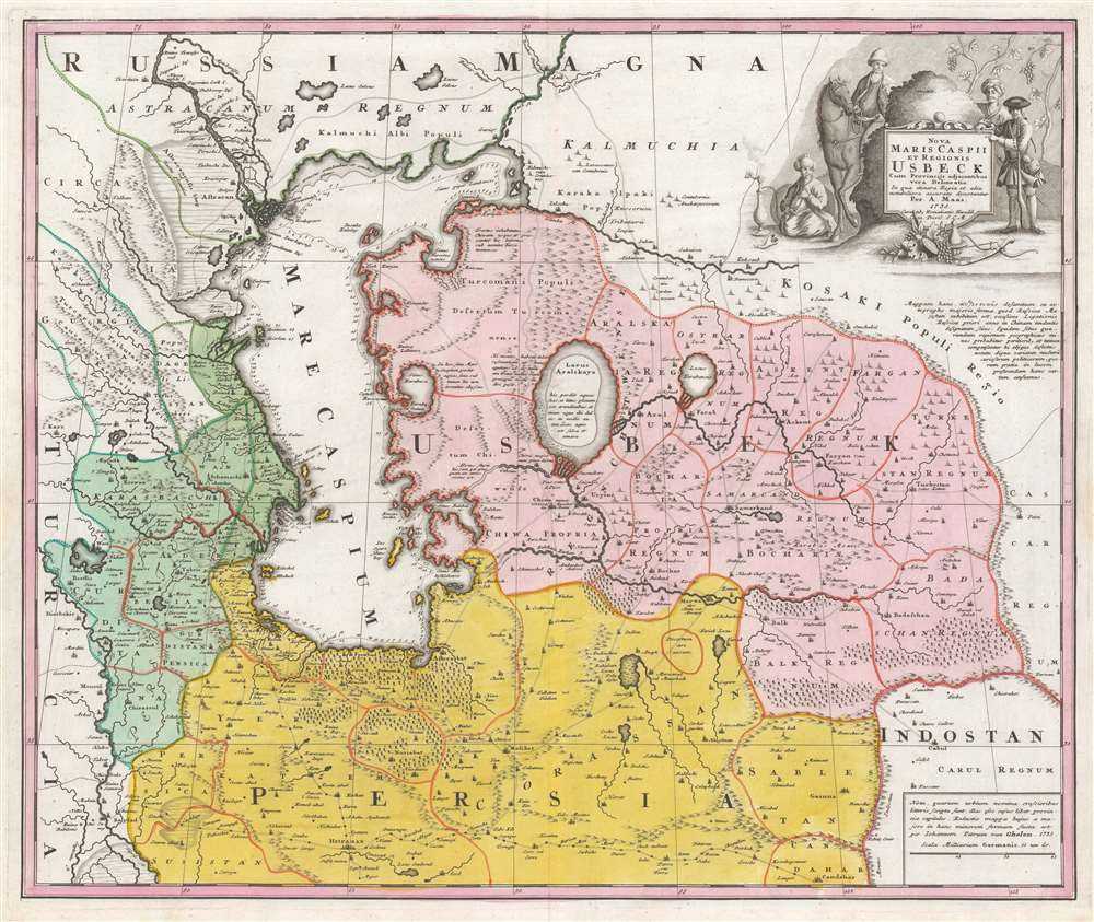
1735 Homann / Maas Map of the Caspian Sea, Persia, Uzbekistan
$1,250.00
1735 Homann / Maas Map of the Caspian Sea, Persia, Uzbekistan
CaspianUzbekistan-homannheirs-1735$625.00

Title
Nova Maris Caspii et Regionis Usbeck cum Provincijs adjacentibus vera Delineatio.
1735 (dated) 19.25 x 23 in (48.895 x 58.42 cm) 1 : 4000000
1735 (dated) 19.25 x 23 in (48.895 x 58.42 cm) 1 : 4000000
Description
This is Abraham Maas' map of Uzbekistan and the Caspian Region, edited by Johann Peter von Ghelen and published by Homann Heirs in 1735. It was the first map to show the results of Peter the Great's initiatives to chart this ill-understood frontier of the Russian Empire, and it is the first printed map specifically of the Uzbek region. The map shows the area around the Caspian Sea and northern Iran. A broad area running eastwards from the Caspian is marked 'Uzbek;' this encompasses Turkmenistan, Uzbekistan, Kyrgyzstan, Tajikistan and part of Kazakhstan.
Maas' Original Manuscript
Following Tsar Peter's 1723 annexation of the western coast of the Caspian Sea, an embassy was sent Khiva, Bukhara and Balkh; Maas is thought to have been in attendance. The embassy produced a map published in Moscow that year, and submitted in a manuscript to the Tsar preserved the library of the Russian Academy of Sciences, St. Petersburg. Maas produced a faithful copy of that Russian map, translated to Latin. Von Ghelen's edition, committed to print here by Homann Heirs, presents for the first time indigenous toponymy east of the Caspian Sea. And indeed, Maas' map reveals a catalog of new place names: countries, administrative regions, deserts, seas, mountains, and towns which not previously known to western geographers. In addition, a network of roads between linking the Caspian to Kabul is shown.Key Silk Road Routes
Beginning in the west with Baghdad (lower left) the major route reaching east can be seen running to Isfahan, and ultimately Kandahar. Northern branches link Samarkhand, Kabul, and Kashgar.The Aral Sea
This is one of the first maps to detail the Aral Sea: then a massive endorheic lake, now an infamous desert. It is one of the earliest maps to distinguish the Aral as separate from the Caspian. Running east-to-west are the Amu and the Syr rivers, both flowing into the Aral. An ancient diversion of the Amu from the Aral Sea into the Caspian can also be seen.A Beautiful Engraving
The map presents Maas' rich detail and copious notation clearly and legibly. Forests, mountains, and wetlands are shown pictorially. The Caspian shoreline is marked with depth soundings. An attractive cartouche depicts three Uzbeks and a Streltsy - a Muscovite infantryman - situated in a vineyard. At the base of the cartouche are laid a scimitar, a bow and arrow, and bunches of grapes. One of the Uzbeks is seated, his shoes removed, leisurely smoking a shisha pipe.Publication History and Census
This map was engraved by the Homann Heirs as a separate issue, but was also included in made-to-order atlases. It is known in a single state. The separate map is well represented in institutional collections.CartographerS
Homann Heirs (1730 - 1848) were a map publishing house based in Nuremberg, Germany, in the middle to late 18th century. After the great mapmaker Johann Baptist Homann's (1664 - 1724) death, management of the firm passed to his son Johann Christoph Homann (1703 - 1730). J. C. Homann, perhaps realizing that he would not long survive his father, stipulated in his will that the company would be inherited by his two head managers, Johann Georg Ebersberger (1695 - 1760) and Johann Michael Franz (1700 - 1761), and that it would publish only under the name 'Homann Heirs'. This designation, in various forms (Homannsche Heirs, Heritiers de Homann, Lat Homannianos Herod, Homannschen Erben, etc..) appears on maps from about 1731 onwards. The firm continued to publish maps in ever diminishing quantities until the death of its last owner, Christoph Franz Fembo (1781 - 1848). More by this mapmaker...
Abraham Maas (fl. 1715-1735) was a Dutch cartographer; little is known of his background, but he was among the western European geographers employed at the Russian Academy of Sciences. He is known to have produced maps of the Gulf of Finland (1700), the River Dessekebe (1706), and the first map to apply the name 'Uzbek' geographically, Tabula Nova de Mare Caspium et Usbekorum region.) The latter would provide the basis for Nova Maris Caspii et regionis Usbeck, cum provincijs adjacentibus vera delinetio), reduced by Johann Peter van Ghelen and published by Homanns Heirs in 1735. He also produced a very accurate chart of St. Petersburg in 1734. Learn More...
Johann Peter Van Ghelen (1673-1754) was a Viennese printer, publisher and bookseller; Perhaps in his capacity as Court Printer to the Holy Roman Emperor, he produced several maps and battle plans: among them his,Wahre Abbildung der durch die glorreiche Russische Waffen den 2. Julii 1737 mit Sturm eroberten Festung Oczakoff, the 1738 Plan der Attaque deren Turken den 9. October 1738 auf die Schantz Ratscha, and Attaque deren Wurfen auf die Linie bey Belgrad den 26. September 1738. He also executed the print version of Abraham Maas' Nova Maris Caspii et Regionis Usbeck in 1735. Learn More...
Condition
Excellent. An untrimmed example in original color.
References
OCLC 5475135. Nebenzahl, K., Mapping the Silk Road and Beyond, 4.11. Kamoliddijn, Shamsiddin S., The Place of Abraham Maas' Map in the Evolution of Central Asian Toponymy (Ege Üniversitesi), 2006.