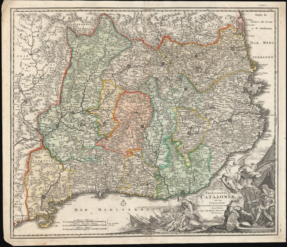
1707 Homann Map of Catalonia, Spain
Cataloniae-homann-1707$750.00

Title
Principatus Cataloniae nec non Comitatuum Ruscinonensisz Et Cerretaniae Nova Tabula.Principatus Cataloniae nec non Comitatuum Ruscinonensis Et Cerretaniae Nova Tabula.
1707 (undated) 20.5 x 23.75 in (52.07 x 60.325 cm) 1 : 600000
1707 (undated) 20.5 x 23.75 in (52.07 x 60.325 cm) 1 : 600000
Description
A c. 1707 map of Catalonia, Spain, by Johann Baptist Homann. It depicts the region during the War of Spanish Succession (1701 - 1714), a catastrophic event in local history which caused Catalonia to (temporarily) lose its historic autonomy.
At bottom-right, an elaborate cartouche includes battle scenes, the figure of Justice weighing scales, Perseus preparing to behead Medusa, and a winged figure blowing a horn, likely representing the archangel Gabriel. This dramatic imagery was in part a product of the historical context in which the map was produced, during the War of the Spanish Succession (discussed below). A figure likely representing Barcelona (note the mural crown indicating a city or city-state) kneels before a seated monarch. It is unclear if this is meant to be Philip V or Archduke Charles, but the shield of the kneeling figure appears to reflect the coat of arms of Philip V, incorporating fleurs de lis. Moreover, the figures charging into battle at left hold a flag adorned with fleurs de lis. Whether this reflects Homann's political leanings, the state of reality at the time of printing, or an expectation of an ultimate Bourbon victory in the conflict is unclear.
After the 1713 Treaty of Utrecht, a local movement spawned the Army of Catalonia to maintain the region's special rights, but outside support did not materialize as hoped and Barcelona was subjected to a siege by Spanish and French forces, which ended when the city surrendered on September 11, 1714.
As a consequence, Catalonia suffered a forceful integration into the Bourbon-ruled kingdom. The subsequent Nueva Planta Decrees abolished Catalan institutions, laws, and rights, replacing them with those of Castile. However, the loss of self-governance and the suppression of its distinct legal and cultural identity had the very opposite effect of what the Spanish crown intended, laying the groundwork for future demands for autonomy and independence.
Due to the just-mentioned difficulties in dating the map, the OCLC includes some 20 catalog listings of the map issued by Homann (not his heirs or Seutter), making the establishment of an accurate census difficult. Most of the institutions which individually catalog the map are in Europe, with Harvard University and the University of Georgia being the only institutions in North America noted in the OCLC listing it independently. The Beinecke Library at Yale University also holds an example (signed 'cum privilegio,' indicating a date after 1715) not listed in the OCLC.
A Closer Look
Catalonia is divided into its principalities (vegueries). Barcelona appears towards bottom-right, with other cities and towns noted to a remarkable level of detail, including fortified cities such as Cardona, Lleida (Lerida), and Perpignã (or Perpignan, now part of France). Roads, mountains, waterways, ports, anchorages, and other features are also indicated. Three ships appear above the Iles Medes, but their purpose or meaning is not readily apparent.At bottom-right, an elaborate cartouche includes battle scenes, the figure of Justice weighing scales, Perseus preparing to behead Medusa, and a winged figure blowing a horn, likely representing the archangel Gabriel. This dramatic imagery was in part a product of the historical context in which the map was produced, during the War of the Spanish Succession (discussed below). A figure likely representing Barcelona (note the mural crown indicating a city or city-state) kneels before a seated monarch. It is unclear if this is meant to be Philip V or Archduke Charles, but the shield of the kneeling figure appears to reflect the coat of arms of Philip V, incorporating fleurs de lis. Moreover, the figures charging into battle at left hold a flag adorned with fleurs de lis. Whether this reflects Homann's political leanings, the state of reality at the time of printing, or an expectation of an ultimate Bourbon victory in the conflict is unclear.
Historical Context
This map was first issued during the War of the Spanish Succession (1701 - 1714), a dispute between the houses of Bourbon and Habsburg over the Spanish Crown, which drew in multiple foreign powers. Despite Catalonia initially supporting Philip V as a claimant to the throne, infringements on the region's autonomy caused it to reconsider its allegiances, and when the Austrian, English, and Dutch-backed Habsburg Archduke Charles captured Barcelona in 1705, it made sense to switch sides in the conflict. In the end, however, the combined might of France and Bourbon forces in Spain caused Catalonia to find itself on the losing side of the war.After the 1713 Treaty of Utrecht, a local movement spawned the Army of Catalonia to maintain the region's special rights, but outside support did not materialize as hoped and Barcelona was subjected to a siege by Spanish and French forces, which ended when the city surrendered on September 11, 1714.
As a consequence, Catalonia suffered a forceful integration into the Bourbon-ruled kingdom. The subsequent Nueva Planta Decrees abolished Catalan institutions, laws, and rights, replacing them with those of Castile. However, the loss of self-governance and the suppression of its distinct legal and cultural identity had the very opposite effect of what the Spanish crown intended, laying the groundwork for future demands for autonomy and independence.
Publication History and Census
This map was produced by Johann Baptist Homann in the early 18th century. Most examples in institutional catalogs are assigned a generic date of 1720 (though they range from 1702 to 1730, with later reissues of the map by Homann Heirs and Mattheus Seutter complicating matters further). This cartouche imagery is consistent across known examples of the map and does not on its own help to identify the date of the map's printing. Nevertheless, we have noticed at least two states of the map: the present example, without Homann's Privilege (acquired in 1715), and a later state bearing the Privilege. Therefore, this map could not reasonably postdate 1715. The present example is consistent with that held by the Institut Cartogràfic i Geològic de Catalunya, which appeared in a 1707 printing of Homann's Neuer Atlas.Due to the just-mentioned difficulties in dating the map, the OCLC includes some 20 catalog listings of the map issued by Homann (not his heirs or Seutter), making the establishment of an accurate census difficult. Most of the institutions which individually catalog the map are in Europe, with Harvard University and the University of Georgia being the only institutions in North America noted in the OCLC listing it independently. The Beinecke Library at Yale University also holds an example (signed 'cum privilegio,' indicating a date after 1715) not listed in the OCLC.
Cartographer
Johann Baptist Homann (March 20, 1664 - July 1, 1724) was the most prominent and prolific map publisher of the 18th century. Homann was born in Oberkammlach, a small town near Kammlach, Bavaria, Germany. As a young man, Homann studied in a Jesuit school and nursed ambitions of becoming a Dominican priest. Nonetheless, he converted to Protestantism in 1687, when he was 23. It is not clear where he mastered engraving, but we believe it may have been in Amsterdam. Homann's earliest work we have identified is about 1689, and already exhibits a high degree of mastery. Around 1691, Homann moved to Nuremberg and registered as a notary. By this time, he was already making maps, and very good ones at that. He produced a map of the environs of Nürnberg in 1691/92, which suggests he was already a master engraver. Around 1693, Homann briefly relocated to Vienna, where he lived and studied printing and copper plate engraving until 1695. Until 1702, he worked in Nuremberg in the map trade under Jacob von Sandrart (1630 - 1708) and then David Funck (1642 - 1709). Afterward, he returned to Nuremberg, where, in 1702, he founded the commercial publishing firm that would bear his name. In the next five years, Homann produced hundreds of maps and developed a distinctive style characterized by heavy, detailed engraving, elaborate allegorical cartouche work, and vivid hand color. Due to the lower cost of printing in Germany, the Homann firm could undercut the dominant French and Dutch publishing houses while matching their diversity and quality. Despite copious output, Homann did not release his first major atlas until the 33-map Neuer Atlas of 1707, followed by a 60-map edition of 1710. By 1715, Homann's rising star caught the attention of the Holy Roman Emperor Charles VI, who appointed him Imperial Cartographer. In the same year, he was also appointed a member of the Royal Academy of Sciences in Berlin. Homann's prestigious title came with several significant advantages, including access to the most up-to-date cartographic information as well as the 'Privilege'. The Privilege was a type of early copyright offered to very few by the Holy Roman Emperor. Though less sophisticated than modern copyright legislation, the Privilege offered limited protection for several years. Most all J. B. Homann maps printed between 1715 and 1730 bear the inscription 'Cum Priviligio' or some variation. Following Homann's death in 1724, the firm's map plates and management passed to his son, Johann Christoph Homann (1703 - 1730). J. C. Homann, perhaps realizing that he would not long survive his father, stipulated in his will that the company would be inherited by his two head managers, Johann Georg Ebersberger (1695 - 1760) and Johann Michael Franz (1700 - 1761), and that it would publish only under the name 'Homann Heirs'. This designation, in various forms (Homannsche Heirs, Heritiers de Homann, Lat Homannianos Herod, Homannschen Erben, etc.) appears on maps from about 1731 onwards. The firm continued to publish maps in ever-diminishing quantities until the death of its last owner, Christoph Franz Fembo (1781 - 1848). More by this mapmaker...
Condition
Good. A few minor margin tears reinforced. Some margin wear and discoloration. Closed centerfold spilt, reinforced on verso, extending from bottom about 3 inches into the map.