This item has been sold, but you can get on the Waitlist to be notified if another example becomes available, or purchase a digital scan.
1693 Pardies Set of 6 Celestial Maps: Stars, Constellations, Comets
CelestialSet-pardies-1693$9,000.00

Title
Globi coelestis in tabulas planas redacti descriptio auctore R.P. Ignatio Gastone Pardies Societatis Jesu mathematico opus postumum.
1693 (undated) 21.75 x 31 in (55.245 x 78.74 cm)
1693 (undated) 21.75 x 31 in (55.245 x 78.74 cm)
Description
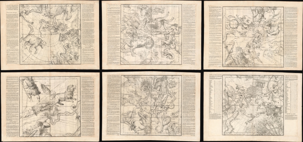
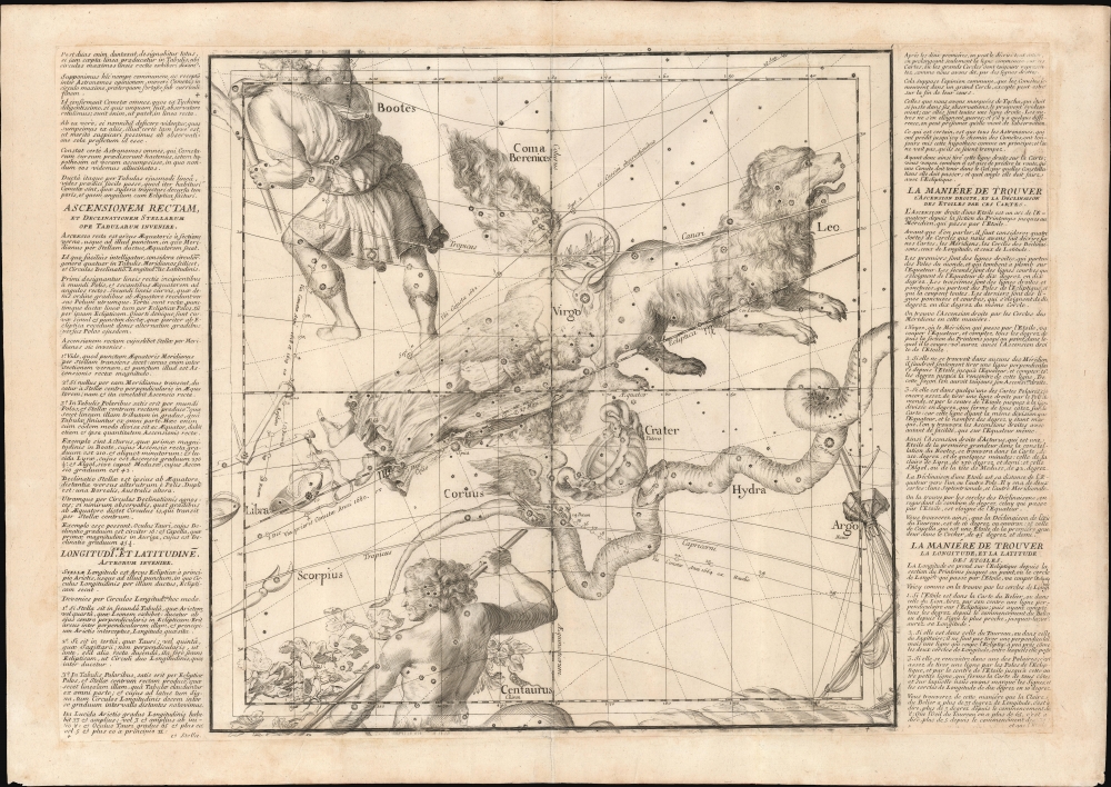
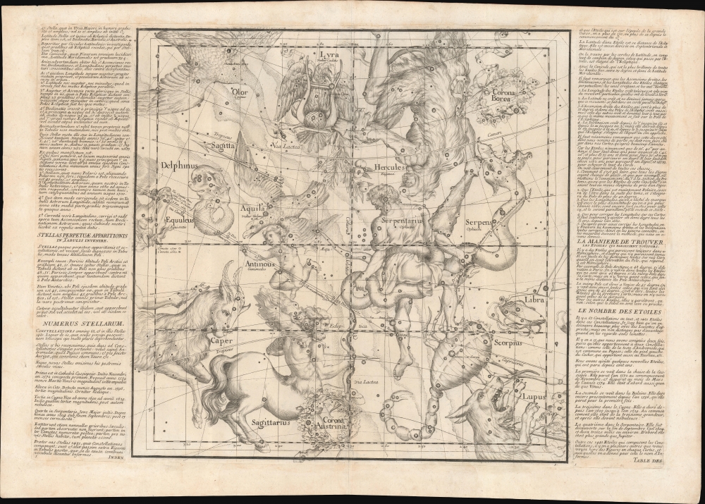
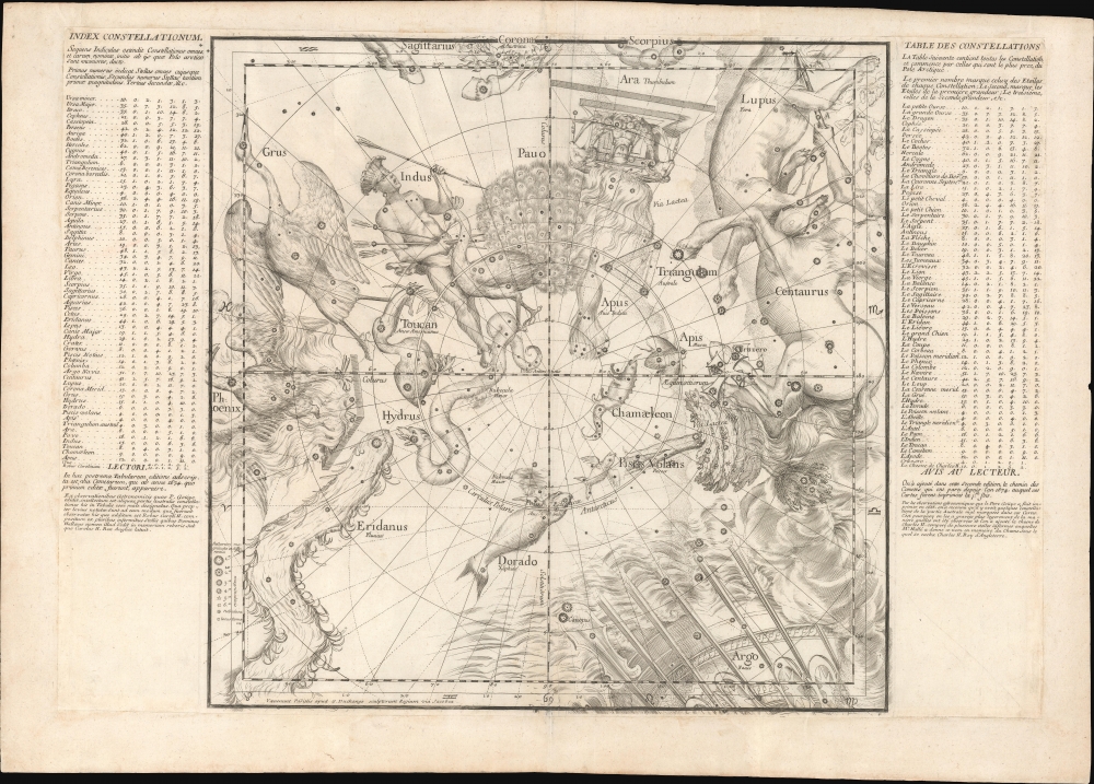
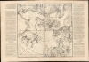
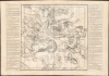
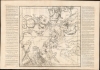
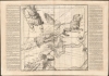
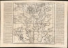
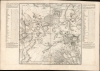
This is a stunning example of Ignace-Gaston Pardies' innovative 1693 celestial maps on 6-part gnomonic projection - here in fine, uncolored loose sheets with an exceptionally strong, crisp impression. Pardies' charts were both revolutionary and influential, emerging as eager scholars and private researchers, aided by ever more sophisticated telescopes, advanced knowledge of astronomy by leaps and bounds.
The 1674 first edition included some 1,481 stars drawn from the observations of Johannes Hevelius, Giovanni Battista Riccioli, Johann Bayer, and Johannes Kepler, with the present second edition updated to about 1500 stars.
According to researcher Deborah J. Warner,
A Closer Look
Pardies followed earlier Jesuit celestial mapmakers Grienberger (1612) and Grassi (1619) in using a gnomonic projection, which visualized the universe as a 6-sided cube. In fact, if the maps were cut out, they could be joined as such. The charts break from most earlier celestial maps in that they have a geocentric perspective rather than a god-eye view; that is to say, they look at the stars as observed from Earth rather than from a point outside the celestial sphere. Such a projection is helpful for observers of the night sky, as it allows for accurate measurement by straight lines between any point on the map.The 1674 first edition included some 1,481 stars drawn from the observations of Johannes Hevelius, Giovanni Battista Riccioli, Johann Bayer, and Johannes Kepler, with the present second edition updated to about 1500 stars.
According to researcher Deborah J. Warner,
The basic style of Pardies' maps was derived from the large globes issued by Blaeu in 1616 - 1622 … The published reports of their observations indicate that Jesuit astronomers throughout the world relied heavily on Pardies' maps for obtaining the coordinates of both old stars and newly discovered ones. Furthermore, while using the maps they improved them by adding new stars and correcting the positions of old ones; many of these revisions were incorporated into the second edition [c. 1690] … Pardies' maps served as a model for the gnomonic maps by Jonas Moore, Doppelmayer, Kordenbusch, and, in the 19th century, the Society for the Diffusion of Useful Knowledge, and for Grimaldi's maps of the Chinese constellations (Warner, pages 196-8).
The Constellations
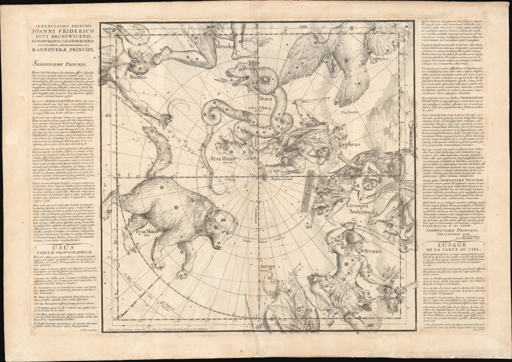
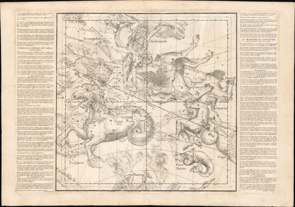
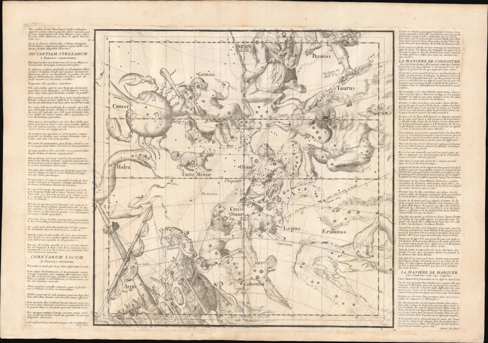
The maps include most of the constellations that we are familiar with today, including the 12 constellations of the Zodiac, as well as other constellations that have since fallen out of fashion. Most are derived from the German astronomer Johann Bayer's 1603 Uranometria. However, where Bayer treats each constellation somewhat independently, Pardies presents them within the greater context of the global night sky. This innovation was not accomplished without difficulty, as it necessitated filling limited space with a wealth of content - a work brilliantly accomplished by the master engraver Guillaume Vallet. In the words of an exhibition catalog issued by the Linda Hall Library of Science, Engineering and Technology in Kansas City, Missouri,Pardies' star atlas is stylistically one of the most attractive ever published. Pardies took his constellation figures primarily from Bayer's Uranometria, but since each chart covers a large section of the sky, these figures had to be carefully integrated, which was not an easy task. Pardies' engraver accomplished this task with great success.... The plate [which] shows Hercules, Ophiuchus, Scorpius, Sagittarius, Aquila, and Lyra...is one of the most stunning compositions in the history of celestial cartography.
Comets
Among other innovations is the inclusion of multiple comet paths with observation dates, including the 1706 path of Halley's Comet. Pardies had a particular interest in comets, having published his 1665 work on the subject, Dissertatio de Motu et Natura Cometarum. For these maps, he draws on his own study, the observations of Tycho Brahe and Edmond Halley, and the research contained in Stanislaw Lubieniecki's Theatrum Cometicum.Side Panels
Each sheet features explanatory side panels in both Latin and French. The first sheet also contains a Latin dedication to Pardies' patron, Johann Friedrich (1625 - 1679), Duke of Brunswick-Lüneburg-Kalenburg-Grubenhagen. The dedication is dated 1673, thus composed shortly before Pardies' sudden sickness and death. Subsequent text is mirrored in both languages and includes instructions on using the maps, text on the observation of comets, and an index of constellations. The side panels were typeset by Sebastien Mabre-Cramoisy.Publication History and Census
Pardies died a year before the first edition was published. The project was taken up by Jesuit scientist and missionary Jean de Fontenay (1643 - 1710), who issued the first edition in 1674. The map plates for this edition were engraved by Guillaume Vallet. This second edition followed in 1693, with considerable updates engraved by Vallet's former apprentice, Gaspard Duchange - whose imprint replaced that of Vallet. A third edition, with few updates, was issued in 1700. All examples are rare. We see a single sheet that has appeared at auction in recent years, fetching some 5,500 USD. Full sets, as here, are even more scarce.CartographerS
Ignace-Gaston Pardies (September 5, 1636 - April 21, 1673) was a French Jesuit scholar, mathematician, publisher, horologist, and astronomer active in the second half of the 17th century. Pardies was born in Pau and joined the Society of Jesus as a novitiate on November 17, 1652. In 1654, he entered the University of Toulouse, studying mathematics and natural philosophy. He was ordained in 1663 and took orders in 1665, after which he taught philosophy and mathematics at the Paris Collège de Clermont (Lycée Louis-le-Grand). He corresponded with the greatest polymaths of his generation, including Isaac Newton (1643 - 1727), Athanasius Kircher (1602 - 1680), Henry Oldenburg (1619 - 1677), Christiaan Huygens (1629 - 1695). His wide variety of works were by his contemporaries. His most significant work in terms of cartography is the celestial atlas, Globi coelestis in tabulas planas redacti descriptio, published posthumously in 1674. During Easter of 1673, he was ministering to the sick prisoners of Bicêtre Hospital, near Paris, from whom he contracted a fever and died a few days later. More by this mapmaker...
Guillaume Vallet (December 6, 1632 - January 1, 1704) was a French engraver active in the late 17th century in Paris and Rome. Vallet was the son of the Paris publisher and print seller Jean Vallet (c. 1636). He first studied engraving under Pierre Daret (1604 - 1678), who sometimes work for his father. From 1655 - 1661, Vallet and his childhood friend, engraver Étienne Picart (1632 - 1721), lived in Rome to studying engraving under the Italian masters. He was a member of the L'Académie Royale de Peinture et de Sculpture from 1664. His students include Gaspard Duchange (1662 - 1757), and his sons, Jérôme (1667 - 1722) and Barthélemy Vallet (1674 - c. 1715). Jérôme Vallet inherited his father's position in the L'Académie, when the latter died in 1704. Vallet was buried in the cemetery of St. Benoit in the 5th arrondissement in Paris. Learn More...
Gaspard Duchange (April 9, 1662 - January 6, 1757) was a French engraver, publisher, and print dealers active in Paris. Duchange studied engraving under Guillaume Vallet (1632 - 1704) and Jean Audran (1667 - 1756), his style more closely resembling the latter. He became a member of the L'Académie Royale de Peinture et de Sculpture in 1707. He collaborated extensively with another Audran student, Nicolas-Dauphin de Beauvais (c. 1687 - 1763), who married his daughter. His own apprentices include Pierre-François Beaumont (1719 - c. 1777), brothers Charles Dupuis (1685 - 1742) and Nicolas-Gabriel Dupuis (1698 - 1771), and François-Bernard Lépicié (1698 - 1755). Learn More...
Source
Pardies, Ignace-Gaston, Globi coelestis in tabulas planas redacti descriptio, (Paris: Jean de Fontenay) 1693.
Condition
Very good. All sheets trimmed and laid down on contemporary laid paper, likely for binding in a composite atlas. Strong crisp impression.
References
Rumsey 6900.001 - 027. Warner, Deborah Jean, The sky explored: Celestial cartography, 1500-1800, pages 196-8. Kanas, Nick, Star Maps: History, Artistry, and Cartography, page 159. Brown, Basil J. W., Astronomical Atlases, Maps and Charts. Pastoureau, Mireille, Les Atlas Francais, XVIe-XVIIe Siecles Repertoire bibliographique et etude, #365.