This item has been sold, but you can get on the Waitlist to be notified if another example becomes available, or purchase a digital scan.
1891 Wyld Map of Central Africa (Kenya, Tanzania, etc) w/ manuscript
CentralAfrica-wyld-1891$600.00

Title
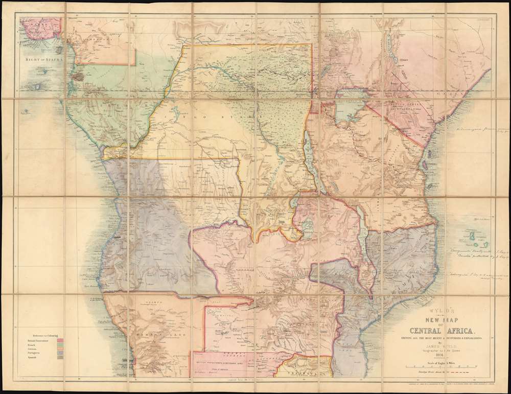
Wyld's New Map of Central Africa, shewing all the most recent discoveries and explorations.
1891 (dated) 24.5 x 31.5 in (62.23 x 80.01 cm) 1 : 6000000
1891 (dated) 24.5 x 31.5 in (62.23 x 80.01 cm) 1 : 6000000
Description
An exceptional and rare find, this is Wyld's 1891 map of Central Africa, one of the few contemporaneous 'Scramble for Africa' maps to illustrate the Anglo-Portuguese conflict over Central Africa (1890 - 1891) and the founding of the British Central African Protectorate. Moreover, the present map features manuscript updates reflecting treaties and events that contributed to defining the Protectorate's borders.
1890 British Ultimatum and the Anglo-Portuguese Treaty of 1891
This map illustrates the founding of British Central African Protectorate following the 1890 British Ultimatum and the subsequent Anglo-Portuguese Treaty of 1891. The 'Ultimatum' was memorandum from the British Government to Portugal, demanding withdrawal from traditional 'discovery based' Portuguese colonial claims in Central Africa in deferment to the 'New Imperialism' concept of Effective Occupation (see below). While the Portuguese argued for a Trans-African Portuguese zone, the British wanted to establish a contiguous North-South line of colonies in anticipation of the 'Cape to Cairo Railway', potentially linking British holdings in a lucrative transportation network. The Ultimatum, enforced by powerful British naval, military, and mercantile forces, ultimate led to the Anglo-Portuguese Treaty of 1891. Under this agreement, boundaries were established for the British Central Africa Protectorate, (now Malawi), and the territories administered by the British South Africa Company in Mashonaland and Matabeleland (now parts of Zimbabwe) and North-Western Rhodesia (now part of Zambia) and Portuguese Mozambique, and also between the British South Africa Company administered territories of North-Eastern Rhodesia (now in Zambia), and Portuguese Angola - all of which is evident on this map!Scramble for Africa
The 'Scramble for Africa' was a series of late 19th century occupations, usurpations, annexations, divisions, and land seizures by European powers in Africa, particularly Britain, France, Belgium, Portugal, and Germany. Beginning around 1881 and continuing until 1914, the Scramble for Africa was part of the era of New Imperialism, marked by heightened occupation and direct ownership of colonial lands rather than the more traditional 'treaty based' colonization. The Scramble led to a number of new African states, many of which remain today, but few of which paid heed to traditional rivalries or cultural distinctions. The scramble culminated in the Berlin Conference of 1884, wherein European colonization of Africa was regulated and made official and the doctrine of Effective Occupation was introduced.Effective Occupation
The 1884-85 Berlin Conference adopted the Doctrine of Effective Occupation as a baseline for establishing and maintaining colonial claims. According to this doctrine, colonial powers needed to prove 'effective occupation.' This means they needed to establish the existence of treaties with local powers, show that their flags were being flown, or have active forts in the region. The doctrine led to increased European military and economic activity in Africa as individual powers sought to bolster their 'effective occupation' claims. While this, in part, led to the advancement of infrastructure in Africa, including the construction of modern facilities such as hospitals and railroads, it also led to more intensive direct ownership of colonial lands by Europeans and the exploitation of indigenous peoples.Coverage
The map's coverage includes central and eastern Africa from 10° N to 23° S, embracing much of modern-day Zaire, Angola, Kenya, Uganda, Tanzania, Malawi, Zambia, Namibia, and Zimbabwe. It is color coded to define territories claimed by various European powers, including the British (red), French (Green), German (yellow), Portuguese (purple), and Spanish (grey). The need to clearly illustrate the diversity of claims accounts for the maps vivid and unusual coloration.Publication History and Census
This map was published by James John Cooper Wyld (184 - 1907), the last descendent of James Wyld I (1790 - 1836) to work in the map trade. There are two editions, 1890 and 1891 (present example), each is significant reflecting different phases in the Anglo-Portuguese conflict over Central Asia: the 1890 British Ultimatum and the subsequent Anglo-Portuguese Treaty of 1891. This map is scarce. We have identified only 4 examples of this, the 1891 issue, in institutional collections, and no market history. Of the 1890 issue, we have identified 5 examples, 2 of which passed through the trade in the late 20 years.Cartographer
Wyld (1823 - 1893) was a British publishing firm active throughout the 19th century. It was operated by James Wyld I (1790 - 1836) and his son James Wyld II (November 20, 1812 - 1887) were the principles of an English mapmaking dynasty active in London during much of the 19th century. The elder Wyld was a map publisher under William Faden (1749 - 1836) and did considerable work on the Ordinance Survey. On Faden's retirement in 1823, Wyld took over Faden's workshop, acquiring many of his plates. Wyld's work can often be distinguished from his son's maps through his imprint, which he signed as 'Successor to Faden'. Following in his father's footsteps, the younger Wyld joined the Royal Geographical Society in 1830 at the tender age of 18. When his father died in 1836, James Wyld II was prepared to fully take over and expand his father's considerable cartographic enterprise. Like his father and Faden, Wyld II held the title of official Geographer to the Crown, in this case, Queen Victoria. In 1852, he moved operations from William Faden's old office at Charing Cross East (1837 - 1852) to a new, larger space at 475 Strand. Wyld II also chose to remove Faden's name from all of his updated map plates. Wyld II continued to update and republish both his father's work and the work of William Faden well into the late 1880s. One of Wyld's most eccentric and notable achievements is his 1851 construction of a globe 19 meters (60 feet) in diameter in the heart of Leicester Square, London. In the 1840s, Wyld also embarked upon a political career, being elected to parliament in 1847 and again in 1857. He died in 1887 following a prolific and distinguished career. After Wyld II's death, the family business was briefly taken over by James John Cooper Wyld (1844 - 1907), his son, who ran it from 1887 to 1893 before selling the business to Edward Stanford. All three Wylds are notable for producing, in addition to their atlas maps, short-run maps expounding upon important historical events - illustrating history as it was happening - among them are maps related to the California Gold Rush, the New South Wales Gold Rush, the Scramble for Africa, the Oregon Question, and more. More by this mapmaker...
Condition
Very good. Backed on original linen. A few very minor edge splits to old linen. Otherwise, stable and clean. Original if unusual color.
References
OCLC 1050162495. Afriterra (1890) 2801.