1748 Vaugondy Map of Bavaria and Salzburg, Germany
CercleBaviere-vaugondy-1748$100.00

Title
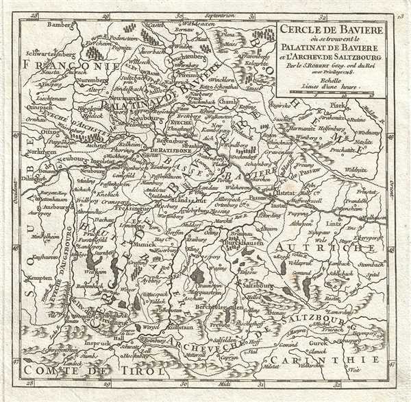
Cercle De Baviere ou se trouvent le Palatinat de Baviere et l'Archev. de Saltzbourg.
1748 (dated) 7 x 7 in (17.78 x 17.78 cm) 1 : 2300000
1748 (dated) 7 x 7 in (17.78 x 17.78 cm) 1 : 2300000
Description
This is a beautiful 1748 map of the Bavaria, in the southeast part of Germany by Robert de Vaugondy. It includes the Archbishopric of Saltzburg, and the Electorate of Bavaria and extends from Bamberg southto Innsbruck and east as far as Linz. Rivers, roads, lakes and other topography is also noted throughout, with mountains beautifully rendered in profile.
Prior to the French Revolutionary War and the Congress of Vienna, the Holy Roman Empire's Circle of Bavaria included the Archbishopric of Salzburg, and was bordered by Franconia, Bohemia, Swabia, and Austria. After several wars with, and occupation by, Austria, the old Bavarian elector Max III Joseph died, leaving Bavaria and the electoral Palatinate to be governed once again in personal union. The Napoleonic Wars dissolved the Holy Roman Empire in 1806, briefly making Bavaria an independent kingdom and doubling its size, until Germany consolidated in 1871.
This map was published in the 1748 edition of Vaugondy's Atlas Portratif Universel et Militaire.
Cartographer
Robert de Vaugondy (fl. c. 1716 - 1786) was French may publishing from run by brothers Gilles (1688 - 1766) and Didier (c. 1723 - 1786) Robert de Vaugondy. They were map publishers, engravers, and cartographers active in Paris during the mid-18th century. The father and son team were the inheritors to the important Nicolas Sanson (1600 - 1667) cartographic firm whose stock supplied much of their initial material. Graduating from Sanson's maps, Gilles, and more particularly Didier, began to produce their own substantial corpus. The Vaugondys were well-respected for the detail and accuracy of their maps, for which they capitalized on the resources of 18th-century Paris to compile the most accurate and fantasy-free maps possible. The Vaugondys compiled each map based on their own geographic knowledge, scholarly research, journals of contemporary explorers and missionaries, and direct astronomical observation. Moreover, unlike many cartographers of this period, they took pains to reference their sources. Nevertheless, even in 18th-century Paris, geographical knowledge was limited - especially regarding those unexplored portions of the world, including the poles, the Pacific Northwest of America, and the interiors of Africa, Australia, and South America. In these areas, the Vaugondys, like their rivals De L'Isle and Buache, must be considered speculative or positivist geographers. Speculative geography was a genre of mapmaking that evolved in Europe, particularly Paris, in the middle to late 18th century. Cartographers in this genre would fill in unknown lands with theories based on their knowledge of cartography, personal geographical theories, and often dubious primary source material gathered by explorers. This approach, which attempted to use the known to validate the unknown, naturally engendered rivalries. Vaugondy's feuds with other cartographers, most specifically Phillipe Buache, resulted in numerous conflicting papers presented before the Academie des Sciences, of which both were members. The era of speculative cartography effectively ended with the late 18th-century explorations of Captain Cook, Jean Francois de Galaup de La Perouse, and George Vancouver. After Didier died, his maps were acquired by Jean-Baptiste Fortin, who in 1787 sold them to Charles-François Delamarche (1740 - 1817). While Delamarche prospered from the Vaugondy maps, he defrauded Vaugondy's window Marie Louise Rosalie Dangy of her rightful inheritance and may even have killed her. More by this mapmaker...
Source
Robert de Vaugondy, G., Atlas Portatif, Universel, et Militaire, (Paris: Vaugondy, Durand, Pissot) 1748.
Condition
Very good. Original platemark visible. Minor foxing.
References
Pedley, M. S., Bel et Utile, p. 179, 273.