This item has been sold, but you can get on the Waitlist to be notified if another example becomes available, or purchase a digital scan.
1733 Petroschi/ Lozano/ Dávila Jesuit Map of Paraguay, Uruguay, and Chaco
Chaco-lozano-1733$4,250.00

Title
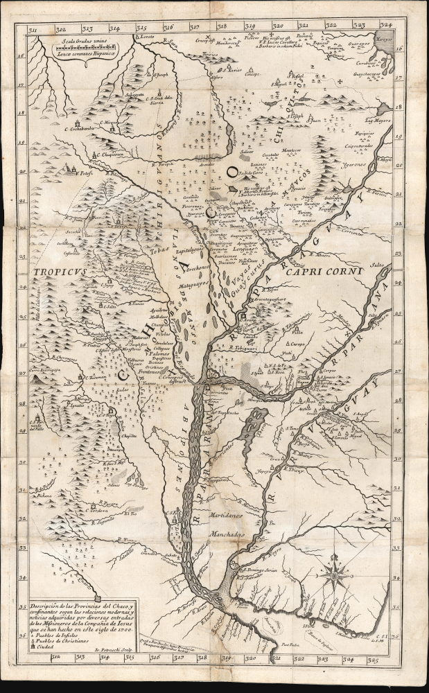
Descripción de las Provincias del Chaco, y confinantes segun las relaciones modernas, y noticias aquiridas por diversas entradas de los Missioneros de la Companía de Iesus que se han hecho en este siglo de 1700.
1733 (dated) 21 x 12.5 in (53.34 x 31.75 cm) 1 : 4500000
1733 (dated) 21 x 12.5 in (53.34 x 31.75 cm) 1 : 4500000
Description
This rare 1733 Pedro Lozano map of central South America, engraved by Giovanni Petroschi, is the first appearance of Antonio Machoni's amendments to Juan Francisco D’Avila's foundational map of the La Plata region. These changes were made both to the Chaco region on the west bank of the Paraguay River (the location of Machoni's missionary work) and the southern coast of what would become Uruguay. The region was a key theatre of Jesuit missionary activity; consequently, the Jesuits produced the first accurate maps of the complex river systems emptying into the Rio de la Plata. The present work illustrates the process of revision over the 18th century, with the contributions of key cartographers and missionaries.
The present map, produced to accompany Pedro Lozano's 1733 description of the Chaco region, was not a rote copy: it included significant revisions both to the Chaco region and also to the southern coast of Uruguay, derived from the contemporary reports of Antonio Machoni, who had been an active missionary in the Chaco up until his posting to Europe as Procurator for the Paraguayan missions. The coast of Uruguay has here half a dozen more placenames than the original D'Avila. The Chaco region is significantly redrawn, not least in its river systems, but also adding copious indigenous placenames and noting the locations of several martyrdoms.
These revisions do not appear on the Stöcklein or the Seutter, which were copied from the early version of the D'Avila. They were, however, incorporated in the 1732 Paraquariae and its 1760 edition.
At the time, the region was dominated by an expansive network of missionary outposts collectively known as the Jesuit Reductions (Reducciones Jesuiticas). Their mission was to convert, tax, govern, and develop the indigenous population, primarily the Tupi-Guarani. The Reductions were extremely successful on all fronts, developing a thriving inland economy largely distinct from the colonially administered coastal territories.
The success of the Reductions led to vast wealth. The Reductions individually and collectively levied and equipped armies from their Guarani converts. Eventually, their prosperity and near independence drew the ire of colonial authorities in Europe, who increasingly sent troops into the Reductions. This spurred a series of armed conflicts, including the Guarani War of 1756, and led to a period known as 'The Suppression.'
A Closer Look
The map reaches as far north as modern-day Bolivia, showing the city of Santa Cruz de la Sierra within the curve of the Guapa River. It reaches as far south as the mouth of the Rio de la Plata. The famous Cerro Potosi, a literal mountain of silver and the location of the Spanish colonial silver mint, also appears. The map reaches far enough east to mark the Isla de Lobos, but does not include the Atlantic-facing coast of Uruguay. It exhibits its best detail in the Misiones region of the Paraná River and the Chaco region west of the Paraguay River. Jesuit missions are noted throughout; a key differentiates cities, Christianized towns, and 'Pueblos de Infieles.'The Source and its Revisions
While the present work is slightly narrower in scope, it is based primarily on Juan Francisco D'Avila's 1722 Paraquariae Provinciae Soc. Jesu cum Adjacentib. Novissima Descriptio. That work - also engraved by Petroschi - was the most complete map of the Rio de la Plata watershed available at the time and provided the basis for most of the century's maps of that region. In his Cartografia Jesuttica del Rio de la Plata, scholar Guillermo Furlong Cardiff hailed this unacquirable map as 'without doubt the most complete and most comprehensive map undertaken by the Jesuits up to the middle of the eighteenth century.' (Buenos Aires, 1936, p. 44). D'Avila's 1722 map was published in Rome in 1726; it was subsequently copied widely, most notably by Stöcklein in 1728 and Seutter in 1730.The present map, produced to accompany Pedro Lozano's 1733 description of the Chaco region, was not a rote copy: it included significant revisions both to the Chaco region and also to the southern coast of Uruguay, derived from the contemporary reports of Antonio Machoni, who had been an active missionary in the Chaco up until his posting to Europe as Procurator for the Paraguayan missions. The coast of Uruguay has here half a dozen more placenames than the original D'Avila. The Chaco region is significantly redrawn, not least in its river systems, but also adding copious indigenous placenames and noting the locations of several martyrdoms.
These revisions do not appear on the Stöcklein or the Seutter, which were copied from the early version of the D'Avila. They were, however, incorporated in the 1732 Paraquariae and its 1760 edition.
Jesuit Reductions and the Suppression
The underlying cartography took D'Avila more than 10 years to compile. He began work on this map around 1712 at the order of the Father Provincial. In a letter dated 1722, D'Avila discloses that the map was made so that the Superior General Michelangelo Tamburini (1648 - 1730) could better understand distances between the Jesuit establishments in order to manage the transference of personnel.At the time, the region was dominated by an expansive network of missionary outposts collectively known as the Jesuit Reductions (Reducciones Jesuiticas). Their mission was to convert, tax, govern, and develop the indigenous population, primarily the Tupi-Guarani. The Reductions were extremely successful on all fronts, developing a thriving inland economy largely distinct from the colonially administered coastal territories.
The success of the Reductions led to vast wealth. The Reductions individually and collectively levied and equipped armies from their Guarani converts. Eventually, their prosperity and near independence drew the ire of colonial authorities in Europe, who increasingly sent troops into the Reductions. This spurred a series of armed conflicts, including the Guarani War of 1756, and led to a period known as 'The Suppression.'
Publication History and Census
This map was engraved by Giovanni Petroschi for inclusion in Pedro Lozano's 1733 Descripcion chorographica del terreno, rios, arboles, y animales de las dilatadissimas provincias del gran Chaco.... The book is well represented in institutional collections, with about 35 examples listed in OCLC. The separate map is scarce; we see only two examples listed with the British Library (misdated) and the National Library of Chile. It is rare on the market. An 1837 lithograph facsimile is less rare.CartographerS
Juan Francisco d'Avila (1682 - 1733) was a Spanish colonial missionary and Jesuit lay brother active in Paraguay and Argentina in the early 17th century. D'Avila was born in Buenos Aires. He spent 10 years between 1712 and 1722 mapping the Jesuit Reductions in the Rio de La Plata Basin. Little else has been recorded of his life. More by this mapmaker...
Giovanni Petroschi (1715 - 1766) was an Italian engraver, cartographer, and map publisher based in Rome. He was considered the foremost authority on Latin American cartography in the first half of the 18th century. He published several important Jesuit maps, including Carolo Brentano's Provincia Quitensis (1751) and Jose Antonio de Sylverio Villaseñor y Sánchez 's map of Mexico (1754). Although significant as a cartographer, Petroschi, like many Jesuit publishers, lived humbly in religious obscurity. Learn More...
Antonio Machoni (1671 - 1753) was a Sardinian Jesuit missionary and scholar. Upon ordination in 1698, he was sent to the Missions of Paraguay. He participated in Esteban de Urízar's 1708 exploration of the Chaco, west of the Paraguay River. Thereafter, he lived and worked in the Gran Chaco region. During this period, he produced a grammar of the Lulé people of the Chaco, whose mission Machoni was in charge of. In 1728, he was sent back to Spain and Rome to serve as representative there for the Paraguayan missions. While in Europe, he published (in 1732) his Lulé grammar; it is probably during this period that he applied corrections to D'Avila's cartography of the Chaco region, which would remain in that foundational work in its 1732 and later editions. In 1733, he returned to South America, eventually becoming Provincial of the Jesuit Province of Paraguay, a position he would hold until 1743. Learn More...
Source
Lozano, Pedro, Descripcion chorographica del terreno, rios, arboles, y animales de las dilatadissimas provincias del gran Chaco.... (Cordoba: Balbas) 1733.
Condition
Good. Mended splits at two folds, mended tear at bottom near centerfold, no loss.
References
OCLC 556867188. 'Jesuit Mission in Spanish America, 18th Century', Imago Mundi, Vol. 15, (1960), pp. 114-118 (context; map not here listed). Cardiff, Guillermo Furlong, Cartografía Jesuítica del Rio de la Plata, #24.