This item has been sold, but you can get on the Waitlist to be notified if another example becomes available, or purchase a digital scan.
1867 Weyss Map of the Battlefield of Chancellorsville during the U.S. Civil War
Chancellorsville-weyss-1867$325.00

Title
Chancellorville.
1867 (dated) 23 x 25.25 in (58.42 x 64.135 cm) 1 : 21120
1867 (dated) 23 x 25.25 in (58.42 x 64.135 cm) 1 : 21120
Description
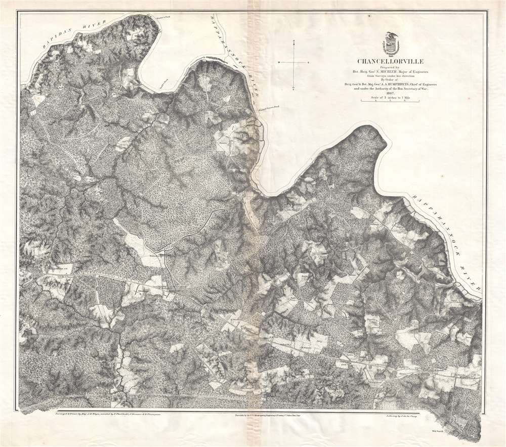
This is a rare 1867 John Weyss and Nathaniel Michler map of the battlefield of Chancellorsville in Spotsylvania County, Virginia. The map depicts the region from James Taylor's homestead on the Orange Turnpike to the Rappahannock River and from Foster's Ford on the Rapidan River to an unfinished railroad that runs roughly parallel to the Orange Turnpike and Haxel Run. Fortifications are illustrated throughout, although they remain unlabeled, so the viewer is unable to know whether the fortifications are Confederate or Union lines without some prior knowledge. These lines are, most likely, Union Major General Joseph Hooker's defensive lines. Apart from the lack of military notations, the map presents a highly detailed depiction of the region, including numerous homesteads that are identified by the owner's last name, forests, fields, streams, and rivers. The Orange Turnpike nearly divides the region in two, while an unfinished railroad line traverses the map near the bottom border. Chancellorsville itself is situated along the Orange Turnpike in the bottom left quadrant.
The Battle of Chancellorsville
Known as Confederate General Robert E. Lee's 'perfect battle', the Battle of Chancellorsville was fought by General Lee's Army of Northern Virginia and Union Major General Joseph Hooker's Army of the Potomac. Fought between April 30 and May 6, 1863, Chancellorsville was a Confederate victory. Lee's force was half the size of Hooker's, but, in a daring move, Lee split his army in two, so as to distract Union General George Stoneman's cavalry and attack Hooker's main force around Chancellorsville. Both sides suffered horrendous numbers of casualties, numbering over 30,000 between the two sides. Even though Lee managed to defeat a superior force, his victory was mostly hollow due to the death of Lieutenant General Thomas J. 'Stonewall' Jackson due to friendly fire and his inability to prevent the Union withdrawal across the Rappahannock River.Publication History and Census
This map was surveyed and drawn by Major John E. Weyss under the command of Nathaniel Michler engraved by Julius Bien, and published by the War Department in Military Maps illustrating the Operations of the Armies of the Potomac and James in 1869. While this map is well represented in institutional collections, it is rare on the private market.CartographerS
John E. Weyss (1820 - June 24, 1903) was an Austrian-American illustrator, cartographer, and engineer. Born in Vienna, Weyss immigrated to the United States in 1848 and settled in New York. He served as a member of the U.S. Government's Mexican Boundary Survey (1849 - 1855), led by Major William Hemsley Emory, because of his training as an illustrator. In the capacity of a civilian artist working for the army, Weyss contributed several illustrations for Emory's report, which was published in 1857-59. Weyss is also credited on eleven of the report's maps. At the outbreak of the American Civil War, Weyss held a position as a civil engineer for the state of Kentucky. Weyss received a commission as a major from the Governor of Kentucky and, due to his professional experience, was assigned to the staff of Captain Nathaniel Michler, the chief topographical officer in the Army of the Ohio. In this role he did survey work for maps of the vicinity of Shiloh and Corinth, both sites of major Civil War battles. Weyss then joined Captain Michler when he moved to the staff of General Rosecrans in late 1862, for whom they made a series of maps of the Battle of Stones River. Weyss and Michler were then transferred to the Army of the Potomac in May, 1863. One of Weyss's first assignments for the Army of the Potomac was a map of the vicinity of Harper's Ferry, Virginia, for which he produced a highly detailed map of the very complex topography of the region. Soon, Weyss was made responsible for the day-to-day detailed mapping during the siege at Petersburg. After the war, Weyss served as the principal surveyor under the direction of Michler during the creation of the atlas Military maps illustrating the operations of the armies of the Potomac and James, May 4th 1864 to April 9th 1865, that was published in 1869. Weyss served the U.S. Army Corps of Engineers for another twenty years, until he retired sometime in the 1880s. Weyss died on June 4, 1903, in Washington, D.C. More by this mapmaker...
Nathaniel Michler (September 13, 1827 - July 17, 1881) was an American military officer and mapmaker who served during the American Civil War. Born in Easton, Pennsylvania, Michler attended West Point, from which he graduated seventh in his class. Commissioned as a 2nd Lieutenant in the Topographical Engineers, Michler participated in the Mexican Boundary Survey from 1851 until 1857, when he was transferred to serve as the chief topographical engineer in surveys for a proposed canal from the Gulf of Darien to the Pacific Ocean from 1858 until 1860. He held the rank of Captain at the outbreak of the American Civil War and served with the Army of the Cumberland from 1861 - 1863, then was transferred to the Army of the Potomac and built defensive works for the Union Army at the Battles of the Wilderness, Spotsylvania, Cold Harbor, and Petersburg. He was promoted to Colonel in August 1864 and brevetted Brigadier General in April 1865. After the war, Michler served as superintendent in the District of Columbia until 1871 and from 1872 to 1875 was chief engineer with the General Commanding Division of the Pacific. He acted as military attaché for the United States Legation in Vienna, Austria from 1878 to 1880. Learn More...
Julius (Julien) Bien (September 27, 1826 - December 21, 1909) was a German-Jewish lithographer and engraver based in New York City. Bien was born in Naumburg, Germany. He was educated at the Academy of Fine Arts, Cassell and at Städel's Institute, Frankfurt-am-Main. Following the suppression of the anti-autocratic German Revolutions of 1848, Bien, who participated in the pan-German movement, found himself out of favor in his home country and joined the mass German immigration to the United States. Bien can be found in New York as early as 1849. He established the New York Lithographing, Engraving & Printing Company in New York that focused on the emergent chromo-lithograph process - a method of printing color using lithographic plates. His work drew the attention of the U.S. Government Printing Office which contracted him to produce countless government maps and surveys, including the Pacific Railroad Surveys, the census, numerous coast surveys, and various maps relating to the American Civil War. Bien also issued several atlases both privately and in conjunction with a relation, Joseph Bien. At the height of his career Bien was elected president of the American Lithographers Association. After his death in 1909, Bien's firm was taken over by his son who promptly ran it into insolvency. The firm was sold to Sheldon Franklin, who, as part of the deal, retained the right to publish under the Julius Bien imprint. In addition to his work as a printer, Bien was active in the New York German Jewish community. He was director of the New York Hebrew Technical Institute, the New York Hebrew Orphan Asylum, and president of the B'nai B'rith Order. Learn More...
Source
War Department, Military Maps illustrating the Operations of the Armies of the Potomac and James May 4th 1864 to April 9th 1865 including Battlefields of the Wilderness, Spottsylvania, Northanna, Totopotomoy, Cold Harbor, The Siege of Petersburg and Richmond Battlefields of Five Forks, Jetersville and Sailor's Creek, Highbridge, Farmville, and Appomattox Court-House. (Washington) 1869.
Military Maps Illustrating the Operations of the Armies of the Potomac and James, published in 1869, compiled all the maps created by Major Nathaniel Michler and Major John E. Weyss of all the major battlefields of the eastern theater of war during the American Civil War. These maps blended together surveys done by soldiers both before and during battles and work done by Weiss and his team of engineers after the war was over. Many of these maps were reduced in order to be republished in the Atlas to Accompany the Official Records of the Union and Confederate Armies, which has become the standard reference for Civil War military maps.
Condition
Very good. Toning and wear along original centerfold. Verso reinforcement to original centerfold. Blank on verso.
References
LOC G3884.C36S5 1863 .M51. Rumsey 3881.003. OCLC 56781318.