1875 Meiji 8 Japanese Map of Bangkok, Thailand (Siam)
ChaoPhrayaBangkok-meiji-1875-2$600.00

Title
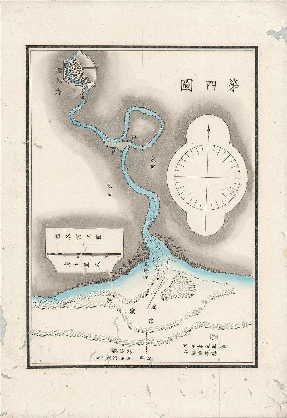
第四圖 / The Fourth Map.
1875 (dated) 9 x 6.5 in (22.86 x 16.51 cm) 1 : 200000
1875 (dated) 9 x 6.5 in (22.86 x 16.51 cm) 1 : 200000
Description
A scarce 1875 (Meiji 8) Japanese map and chart of the Chao Phraya River up to the city of Bangkok. Japanese interest in the region increased considerably in the late 19th century as Japan emerged from the Meiji Restoration and sought to emulate Western empires' interests and activities in Southeast Asia.
On the water, two small canals (渠) are indicated. Shallow waters are signified by dots, while a dashed line at the mouth of the Chao Phraya shows the route boats generally take to access Bangkok. At bottom, anchorages are shown along with notes about the effects of winds blowing from east and west. A lookout post (見張所) sits at the mouth of the river. A scale under the title is provided in nautical miles.
At the time this map was produced, the fortunes of Japan and Siam were diverging. While Siam had been a major power in Southeast Asia for several centuries, it was bumping up against European powers now operating in the region, especially the British. In 1855, under threat of British gunships, Siam signed an 'unequal treaty' that opened it up to foreign trade and influence, setting off dramatic economic and social changes. The kingdom maintained its autonomy through clever diplomacy, but also because it served as a convenient buffer between French and British interests in Southeast Asia.
Japan underwent a similar process at roughly the same time but was more protected as a set of islands at the far edge of Eurasia. As this map shows, already by 1875, Japanese cartographers had integrated foreign methods and were producing maps of regions far beyond Japan's own shores. As two cultures with long-established trade and cultural ties as well as two of the only countries in Asia to never be colonized, Japan and Siam maintained good relations in the following decades, which ultimately culminated in an alliance during the Second World War.
A Closer Look
The Chao Phraya River winds from top to bottom, running through Bangkok (盤古府) and emptying into the Gulf of Thailand. The characters written on either side of the river (米田) refer to rice fields, while a small forest is denoted near the mouth of the river.On the water, two small canals (渠) are indicated. Shallow waters are signified by dots, while a dashed line at the mouth of the Chao Phraya shows the route boats generally take to access Bangkok. At bottom, anchorages are shown along with notes about the effects of winds blowing from east and west. A lookout post (見張所) sits at the mouth of the river. A scale under the title is provided in nautical miles.
At the time this map was produced, the fortunes of Japan and Siam were diverging. While Siam had been a major power in Southeast Asia for several centuries, it was bumping up against European powers now operating in the region, especially the British. In 1855, under threat of British gunships, Siam signed an 'unequal treaty' that opened it up to foreign trade and influence, setting off dramatic economic and social changes. The kingdom maintained its autonomy through clever diplomacy, but also because it served as a convenient buffer between French and British interests in Southeast Asia.
Japan underwent a similar process at roughly the same time but was more protected as a set of islands at the far edge of Eurasia. As this map shows, already by 1875, Japanese cartographers had integrated foreign methods and were producing maps of regions far beyond Japan's own shores. As two cultures with long-established trade and cultural ties as well as two of the only countries in Asia to never be colonized, Japan and Siam maintained good relations in the following decades, which ultimately culminated in an alliance during the Second World War.
Publication History and Census
This map, simply titled 'The Fourth Map' (第四圖), was prepared to illustrate an extremely rare Meiji Era Japanese travelogue describing a voyage to Thailand or Siam titled Images of Travels in Siam (暹羅紀行圖), published in 1875 by the Ministry of Industry (工部省, Kōbushō), which had a wider range of activities than its name suggests. We have identified only two other examples of this map, located in the archives of the Waseda University Library and the Kyoto University Library.Condition
Average. Significant wormholing. Laid down on Japanese tissue, as issued.
References
OCLC 838714642, 33786201.