This item has been sold, but you can get on the Waitlist to be notified if another example becomes available, or purchase a digital scan.
1727 Valentijn Map of the Chao Phraya River, Thailand (Bangkok)
ChaoPhrayaSiam-valentijn-1726$1,875.00

Title
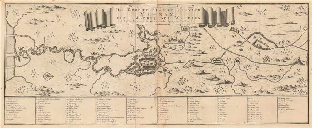
De Groote Siamse Rievier Me-Nam ofte Moeder der Wateren inharen loop met de in vallende Spruyten Verbeeld.
1727 (undated) 12.25 x 30.25 in (31.115 x 76.835 cm)
1727 (undated) 12.25 x 30.25 in (31.115 x 76.835 cm)
Description
This is a rare 1726 Francois Valentijn map of the Chao Phraya River, Thailand. Roughly translated, the title reads, 'The Great Siamese River Me-Nam, or Mother of Waters, its course and its tributaries displayed.' Centered on the Siamese capital of Ayutthaya and oriented to the west, the map extends inland several hundred miles from the Gulf of Thailand to central Thailand. Bangkok, identified as 'Fortres Banckok' appears on the left side of the map as no. 12. At the mouth of the Chao Phraya, described here as the Me-nam, a Dutch flag flies from a building (no. 5), no doubt the VOC (Dutch East India Company) storehouse. This is one of the first published maps to offer accurate first-hand information on the interior of Siam. In total some 101 locations are referenced in the table below the map. The wonderful research below can be attributed to the superb research compiled by Barend J Terwiel and published as François Valentijn’s Map of 'The Great Siamese River Me-Nam'.
Three Source Sections
This map was compiled in three different sections. The first comes from Dutch manuscript maps dating to the late 17th century, with updates added by Dutch merchants stationed at the VOC storehouse near the mouth of the river. Second section centers around they Siamese capital city of Ayutthaya. The third is in fact derived from a Siamese military map of the Upper Mekong.Section 1: The Gulf of Thailand to Ayutthaya
The first section, between the Gulf of Thailand and the capital is based upon exploration by VOC employees. VOC personnel stationed at the Siam warehouse regularly traveled up and down the river as far as the capital at Ayutthaya. While several VOC manuscript maps survive from this time, it is noteworthy that one must have been located at the warehouse in Siam, as the updates here reflect knowledge up to date to about 1722. Quoting Terwiel,At No. 11 there is the intriguing information that the so-called Lat Pho canal near the village of Phra Pradaeng had recently been dug, shortening the first large loop of some nineteen kilometers in the Chaophraya River. The Thai Geographical Encyclopedia states that the digging of the Lat Pho Canal took place in 1722. If this is true, the map with this information should have been sent to Valentijn between 1722 and 1726 when he wrote his opus magnum, during the time when at first Hendrik van der Burg and later Gregorius Hendrik Paagman were 'opperhoofd' in the Dutch Lodge near Ayutthaya.Subsequent research has thrown these dates into question, but has not offered alternatives.
Section 2: Ayutthaya and Vicinity
The second section of the map focuses on the area immediately surrounding Ayutthaya, covering table numbers 42 through 80. Although ostensibly drawing from the work of Vingboons, much is different, andin his treatment of Ayutthaya, Valentijn diverges from all these existing maps in three ways. In the first place, he drew the walls like nobody had before. Second, within the city he identified only the royal palace. More importantly, he located beyond Ayutthaya in all directions monasteries, villages and some prominent features that cannot be found on any other European map of that time.Few of these locations appear on any corresponding European cartography leading most to suggest that the data was drawn from indigenous Siamese cartographic efforts. This is underscored by the fact that place names are merely transliterated Thai words.
Section 3: Ayutthaya and North
This section of the map, from roughly point 83 north, is most remarkable as, at this time, no European had traveled north of Ayutthaya. Regarding this section, Valentijn writes,I shall not bother with describing the other places that are situated further north, for the reader can see them clearly printed here with some mountains, habitations and villages with their Siamese names. At the same time is shown how the river Me Nam higher up north, originating from the inner lake of Tsjamay [Chiang Mai] in the north of Tartary (taking, some say, 15 or 16 days’ travel above the borders of Siam) and thus like a broad stream passes the town Ayutthaya and runs further to the sea, where it rushes with great force, since in the upper reaches three large rivers having joined it.There can be little down that Valentijn was provided with an indigenous Thai map. He misunderstood certain aspects of the map, including directional orientation and scale, but the map it noteworthy for extending as far modern day Luang Prabong (Laos, no. 95 - Muang Kseu), far to the northeast. The last item, 101, identified her as Lipu, refers to the Li Phi / Tat Somphamit waterfall, presently near the border between Laos and Cambodia on the Upper Mekong River. This is significant, for it underscores that the right-hand side of the map does not depict the upper reaches of the Chao Phraya, as Valentijn assumed, but rather the Upper Mekong. The fact that he does not directly connect the two rivers - rather obscuring them beneath the map's title banner, suggests that Valentijn lacked confidence in the cartography.
The VOC and the Dutch East Indies
Francois Valentijn (1666 - 1727), a missionary, printer, and author was among the first to publish on the history and management of the VOC in the East Indies. Cartographic knowledge of the Dutch East Indies was tightly controlled by the VOC throughout the 17th century. Valuable cartographic data was typically shared among VOC pilots in manuscript form and rarely ever submitted to printing. Valentijn spent 16 years in the East Indies as a VOC minister and, as such, doubtless had access to secret charts, such as the Vingboons Atlas. Despite the strict VOC injunction on publishing its valuable maps, Valentijn successfully published his work in 1726. In the same year Johannes van Keulen II was commissioned as official VOC hydrographer and published his own 'secret atlas' of VOC maps. The fact of both were published in 1726 suggests that the era of VOC dominance in the East Indies had nearly come to an end.Publication History and Census
This map was issued in Amsterdam as plate no. 35 in Francois Valentijn's 1726 Oud en nieuw Oost-Indien. It was published by Joannes van Braam and Gerard onder de Linden. Today this important map is exceedingly rare. The OCLC sites just 3 examples but the book is more widely held.Cartographer
Francois Valentijn (April 17, 1666 - August 6, 1727) was a Dutch minister, naturalist, colonial administrator, and historian active in Holland and the East Indies, in the late 17th and early 18th centuries. Valentijn was born in Dordrecht, Holland and studied at the Universities and Leiden and Utrecht before, in 1685, taking a position with the Dutch East India Company (VOC). He remained in the East Indies for about 10 years before returning to Dordrecht. Unable to adjust to life in Europe, he returned to the East Indies in 1705 where he remained for another 9 years. After 19 total years in the Orient working for the VOC, Valentijn once again returned to Holland where he composed his eight volume five part masterwork Oud en Nieuw Oost-Indien. The scope and detail of this work, including over 1000 engraved images and numerous maps was unprecedented with regards to Asia. The work contained some of the finest and most detailed large scale maps of the East Indies ever published. The most important of these focus on Taiwan and Malaya. Valentijn most likely drew on secret VOC manuscript maps and documents, a fact that makes it exceptionally surprising that his works were actually published. Valentijn academic scholarship, in sharp contrast to his cartographic work, is often highly criticized as being self-aggrandizing and, more often than not, plagiarized. More by this mapmaker...
Source
Valentijn, F., Oud en Nieuw Oost-Indien, (Dordrecht: J. van Braam) 1726.
Condition
Good. Minor centerfold discoloration, wear, and soiling, on old fold lines. Old margin fill repair at top center.
References
OCLC 1122801399. Harvard University, HOLLIS 990126248310203941. Terwiel, Barend J., François Valentijn’s Map of 'The Great Siamese River Me-Nam'.