This item has been sold, but you can get on the Waitlist to be notified if another example becomes available, or purchase a digital scan.
1907 Walker Map and Bird's-Eye View of the Charles River, Massachusetts
CharlesRiver-walker-1907-3$325.00

Title
Charles River.
1907 (undated) 19.5 x 26.5 in (49.53 x 67.31 cm)
1907 (undated) 19.5 x 26.5 in (49.53 x 67.31 cm)
Description
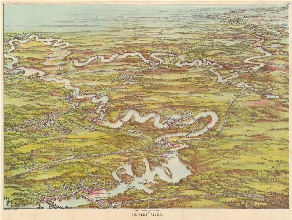
This is a beautiful 1907 bird's-eye view map of the Charles River, Massachusetts, by the Boston publisher George H. Walker. Printed in chromolithography, Walker's view illustrates the winding Charles River from Waltham to Medway and includes Riverside, Newton, Wellesley, South Natick, Dover, Needham, Waban, Dedham, Medfield, Rockville and Highlandville. Several landmarks are also noted, including the Waltham Watch Factory, Mount Feake Cemetery, Norumbega Park, Walker-Gordon Milk Farm, and Echo Bridge near Newton Upper Falls. Dams, bridges, lakes, and pumping stations are identified. Walker also notes a number of railway lines and stations throughout.
Chromolithography
Chromolithography is a color lithographic technique developed in the mid-19th century. The process involved using multiple lithographic stones, one for each color, to yield a rich composite effect. Oftentimes, the process would start with a black basecoat upon which subsequent colors were layered. Some chromolithographs used 30 or more separate lithographic stones to achieve the desired product. Chromolithograph color could also be effectively blended for even more dramatic results. The process became extremely popular in the late 19th and early 20th centuries, when it emerged as the dominate method of color printing. The vivid color chromolithography produced made it exceptionally effective for advertising and propaganda imagery.Publication History and Census
Published by 'George H. Walker Lith. and Pub. Co.', 400 Newbury St., Boston, Massachusetts, in 1907. This view was published in folding format in a pamphlet entitled 'Canoe Map of Charles River;' we see only six examples catalogued in OCLC.Cartographer
George Hiram Walker (January 4, 1852 - November 14, 1927) was a Boston based publisher of books, views, and maps active in the late 19th and early 20th centuries. Born in Springfield, Vermont, Walker started his life as a dry goods merchant but developed an active interest in publishing during the early 1870s. Walker began publishing in 1878 when he partnered with an unknown New York Firm. Two years later, Walker brought the operation in house by partnering with his brother, Oscar W. Walker, in the opening of a lithography studio at 81 Milk Street, Boston. Shortly thereafter the firm expanded to new offices at 160 Tremont Street, Boston. The Walker brothers produced a large corpus of works, most of which focused on travel and tourism in New England. Walker also established the Walker-Gordon Milk Laboratory with Dr. Thomas Morgan Rotch and Gustave Gordon. This interesting investment was based on the premise that infant deaths could be avoided by providing higher quality milk. The company eventually became a great success, producing a high-quality cow milk that closely resembled human breast milk. In the process the Walker-Gordon laboratory developed many of the dairy health standards that are still with us today. Walker married Irene L. Loud on March 25, 1885. More by this mapmaker...
Condition
Very good. Reinforced and stabilized with mends at junctures of folds.
References
OCLC, 78846889.