1912 Bacon Wall Map of the World and Chart of Useful Knowledge
ChartUsefulKnowledge-bacon-1912$6,000.00


Title
Bacon's Chart of Useful Knowledge.
1912 (undated) 40.5 x 30.25 in (102.87 x 76.835 cm) 1 : 84480000
1912 (undated) 40.5 x 30.25 in (102.87 x 76.835 cm) 1 : 84480000
Description
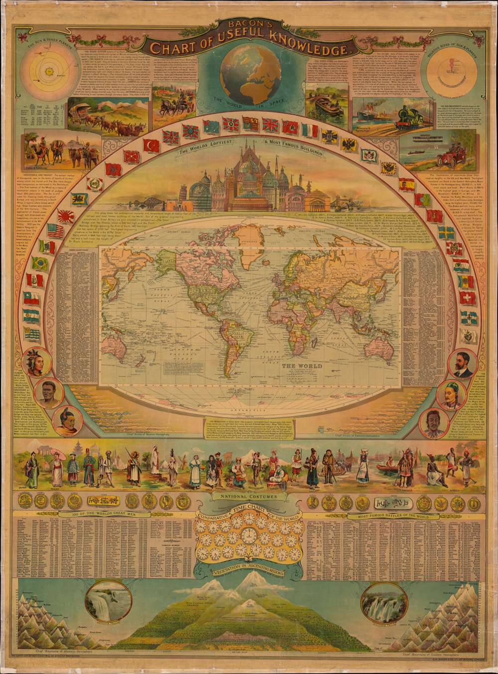
This is George W. Bacon's striking wall-map style compendium of all 'useful knowledge' - a densely informative chromolithographic masterpiece. Bacon's map/chart emerges out of the great age of data collection - a period following the Age of Discovery in which improved transportation and intellectual optimism encouraged a furious effort to catalog, 'collect', and contextualize the natural world. The present map synthesizes these efforts into a single dense infographic aimed at both the next generation of explorer/scientists and the armchair adventurer. Herein, information is effectively summarized and categorized, embracing an impressive range of subjects: astronomy, geography, transportation, ethnology, geology, anthropology, and more.
Below the discussion of the solar system are six vignettes illustrating modes of transportation. These progress from camels and donkeys to ox-drawn wagons and stagecoaches, ending with steamships, steam engines, automobiles, and airplanes. A short discussion of these 'conveyances' appears along the left border.
The Map
The chart's focal point is the world map at center. The map presents the world on a Mercator projection with countries, trade routes, distances, and other detail defined. It is surrounded by the flags of numerous nations, as well as a comparative chart of twenty-four man-made structures, and another of rivers of the Eastern and Western Hemispheres.People and Places
Short 'ethnographic' discussions appear to the left, right, and immediately below this central panel, with six portraits of the 'races of man'. A panel presenting national costumes appears below.Human Society and History
The chart continues with illustrations of some of the world's coinage with exchange rates to British pounds. A table listing '100 of the World's Great Men' from Homer to Cecil Rhodes occupies the left portion of the sheet below the currency and is followed by a list of seventeen famous women. Both are decidedly Anglo-centric. A similar chart lists the 'Most Famous Battles of the World' from the Battle of Troy to the 1905 Battle of Tsushima. A 'comparative time chart of the world' relative to Greenwich separates the two tables.Comparative Mountains
A comparative chart of the heights of the world's tallest mountains occupies the bottom part of the chart. The chief mountains of the Western and Eastern Hemispheres appear in the left and right, respectively, with each peak identified by name. At center, a diagram presents plant life at various altitudes.Astronomy and Transportation
At the top of the sheet, diagrams and a short text focus on the solar system. The diagram in the upper left illustrates the inner solar system, presenting Mercury, Venus, Earth, and Mars' orbits around the Sun. A chart comparing the size of the eight planets and the Sun occupies the top right. An illustration of the Earth as a planet appears at top center.Below the discussion of the solar system are six vignettes illustrating modes of transportation. These progress from camels and donkeys to ox-drawn wagons and stagecoaches, ending with steamships, steam engines, automobiles, and airplanes. A short discussion of these 'conveyances' appears along the left border.
Chromolithography
Chromolithography, sometimes called oleography, is a color lithographic technique developed in the mid-19th century. The process involved using multiple lithographic stones, one for each color, to yield a rich composite effect. Oftentimes, the process would start with a black basecoat upon which subsequent colors were layered. Some chromolithographs used 30 or more separate lithographic stones to achieve the desired product. Chromolithograph color could also be effectively blended for even more dramatic results. The process became extremely popular in the late 19th and early 20th centuries when it emerged as the dominant method of color printing. The vivid color chromolithography produced made it exceptionally effective for advertising and propaganda imagery.Publication History and Census
This c. 1912 chart was created and published in England by George W. Bacon. This chart does not appear in OCLC or any other institutional collection. Rare.Cartographer
George Washington Bacon (1830 - 1922) was a London based book and map publisher active in the mid to late 19th century. Bacon's firm G.W. Bacon and Co. purchased the plates created by Edward Weller for the Weekly Dispatch Atlas then modified and updated them for several of their own important atlases, including The New Ordnance Atlas of the British Isles. In 1893, Bacon & Co. acquired the map publishing business of J. Wyld. Then, around the turn of the century, Bacon & Co. itself was folded into the Scottish publishing house of W.& A.K. Johnston. More by this mapmaker...
Condition
Very good. Full professional restoration. Area of infill to title cartouche no effecting lettering. Small areas of loss along top and bottom margins where once attached to rollers.