This item has been sold, but you can get on the Waitlist to be notified if another example becomes available, or purchase a digital scan.
1879 Texas General Land Office Map of Cherokee County, Texas
CherokeeCounty-texasglo-1879$200.00

Title
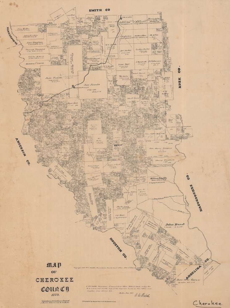
Map of Cherokee County, 1879.
1879 (dated) 27 x 20 in (68.58 x 50.8 cm) 1 : 133334
1879 (dated) 27 x 20 in (68.58 x 50.8 cm) 1 : 133334
Description
An 1879 Texas General Land Office cadastral map of Cherokee County, Texas. The map features manuscript highlighting the relocation of Jacksonville to Troup, to capitalize on the route Great Northern Railroad. Moreover, the early history of the county, from Spanish colonization though to Texas statehood, can be deduced from the plots and other features.
A Closer Look
A variety of plot sizes are displayed with their owners' names. Many of the larger plots are also the oldest, as noted in their date of acquisition (prior to the Texas Revolution). A number of these older properties belonged to Spanish/Mexican settlers who arrived in the area in the late 18th and early 19th century, while others were owned by the earliest Anglo-American settlers in the region. For example, northeast of Jacksonville, along the rail line, is a property belonging to the descendants of Thomas J. Rusk (namesake for the town to the south), an important military and political figure in the Republic and later State of Texas, serving alongside Sam Houston as the state's first two U.S. Senators. The property assigned to the widow of James Dill, towards bottom-right, is notable as the Dills were very early Anglo-American settlers in the area, arriving in 1799. James Dill traded with Mexican settlers and Native Americans and became involved in local politics, serving as an alcalde. A neighboring property belongs to John Durst, son of Joseph Durst (also listed as owner of a property in neighboring Angelina County), another early settler and a political opponent of Dill who also served as an alcalde. The two properties are separated by the San Antonio Road, arguably the oldest road in Texas and oldest highway in the United States.Relocating Jacksonville
The penciled in 'City of Jacksonville' on the land of Jose Pineda is the result of the town's relocation in 1872. When the International - Great Northern Railroad was built through Cherokee County earlier that year, it did not stop at the existing town, leading the town's inhabitants to petition the railroad to survey land for a new town along the tracks. An agreement was reached and the entire town quickly moved. The railroad also gave rise to the town of Troup along the northern edge of the county.Early History of the County
Though not the original inhabitants of the area, the Cherokee, for whom the county is named, and other Native American groups displaced from further east had settled there in the 1820s. Soon afterwards, as White settlers from the east arrived, conflicts over land arose. Though Sam Houston was able to negotiate a treaty with the Cherokee in 1836 on behalf of the Republic of Texas, the Texas Senate rejected it the following year. More settlers arrived and violence increased due to uncertain and contested land claims. This volatile situation led to the 'Killough Massacre' northwest of Jacksonville on October 5, 1838, in which 18 Anglo-Americas settlers were killed or kidnapped by Cherokee warriors unaware of or opposed to an agreement that had been worked out between the Killough family and local Cherokee leaders. The massacre was a precipitating factor in the Cherokee War of 1838-1839, after which the Cherokee were expelled from the area, mostly to the Indian Territory further north (future Oklahoma).Publication History and Census
This map was prepared by the Texas General Land Office in 1879 and printed by August Gast and Co. in St. Louis. According to the records of the GLO displayed by the University of North Texas' 'Portal to Texas History,' the GLO had produced four earlier cadastral maps of the county (1851, 1863, 1871, and 1877). Nevertheless, this appears to be the earliest obtainable edition of the map (i.e., outside of the GLO archives). It is only noted among the holdings of the Library of Congress and the Daughters of the Republic of Texas Library.CartographerS
The Texas General Land Office (GLO) (December 22, 1836 - Present) is an agency of the state government of Texas responsible for the management of land and mineral rights that are owned by the state. Established by the Congress of the Republic of Texas on December 22, 1836, the agency manages Texas's publicly owned land, negotiates and enforces leases concerning the use of that land, and sells public lands. Part of these proceeds are put into the state's Permanent School Fund, which helps fund public education in Texas. The GLO has managed The Alamo in San Antonio since 2011. After Texas was annexed by the United States in 1845, the state maintained control over all its public lands from when it had been a sovereign state, making Texas the only U.S. state to control all its own public lands. All federal land in Texas was acquired either through purchase (for example military bases) or donation (national parks). More by this mapmaker...
August Herman Ludwig Gast (March 10, 1819 - December 24, 1891) was a German-American lithographer. Born in Lippe Detmold, Germany, was educated there, and went into the lithography business with his brother Leopold (March 11, 1810 - March 1, 1898). After participating in the Revolution of 1848, the brothers emigrated to the United States and arrived in New Orleans and, of course, they brought their lithography press with them. them. The duo worked in New York City for a few months, and then spent over a year in Pittsburgh before settling in St. Louis, Missouri in 1852. In St. Louis the brothers founded Leopold Gast and Brother Lighograph Company, which Leopold ran until he sold his share of the business to August in 1866. After Leopold's departure, Gast continued to grow his lithography business, now called August Gast and Company, until he sold it in 1885, when it was one of the largest firms of its kind in the country. After the sale, Gast founded the August Gast Bank Note and Lithograph Company and the Gast Wine Company. Gast died of 'la grippe' in St. Louis at the age of 72. He married his wife Sophie von Laer in 1853. Tragically, Sophie died in 1864. At some point thereafter, Gast married Marie Barthel, with whom he had thirteen children, of whom only four were alive at the time of August Gast's death. Following Gast's death, his son Ferdinand takes over the businesses, and the Gast Wine Company is absorbed by the Gast Brewing Company in 1900. The Gasts continue to prosper and found the Gast Building and Realty Company in 1944, and Ferdinand's grandsons, Ferd Gast and Robert Gast, invest in and develop real estate. Robert created several companies over his lifetime, including those that invest in single family homes and ones to develop, build, and operate amusement parks. Doug Gast, Robert's son, stars a financial investmentsd business in the 1960s, followed by Gast Webbing Restraints in the 1980s, which manufactured automotive parts. By the 2000s, the third generation of Gasts are involved in the family real estate business, and today Gast Companies has consolidated in order to manage their diverse portfolio. Learn More...
Condition
Very good. Fairly even toning. Light foxing and soiling.
References
OCLC 792924993, 310575445.