This item has been sold, but you can get on the Waitlist to be notified if another example becomes available, or purchase a digital scan.
1871 Admiralty Nautical Chart of the Chesapeake Bay
ChesapeakeBay-admiralty-1871$375.00

Title
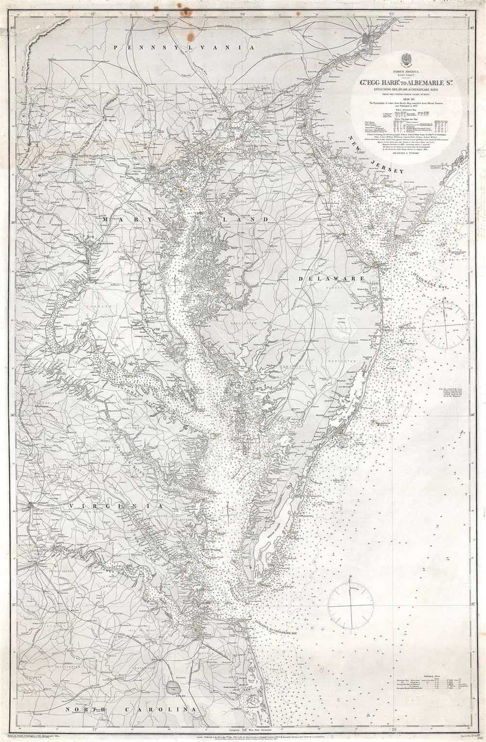
North America East Coast. Great Egg Harbor to Albemarle Sound. Including Delaware and Chesapeake Bays. From The United States Coast Survey. 1859 - 70.
1871 (dated) 35.5 x 25.75 in (90.17 x 65.405 cm) 1 : 437500
1871 (dated) 35.5 x 25.75 in (90.17 x 65.405 cm) 1 : 437500
Description
This is an 1871 British Admiralty nautical chart or maritime map of the Chesapeake Bay and Mid-Atlantic Coast. The map depicts the east coast of the United States from Great Egg Harbor, New Jersey, and up the Delaware River to Philadelphia to the northern reaches of Albemarle Sound in North Carolina. Philadelphia, Baltimore, Wilmington, Washington, D.C., Richmond, Frederiksburg (Fredericksburg), and Petersburg are included. Roads are rendered, along with rail lines, among them the Baltimore and Ohio, the Washington and Baltimore, and the Richmond Frederick and Potomac Railways. Depth soundings extend up Delaware Bay and the Delaware River past Philadelphia, and up the Chesapeake Bay past Baltimore to the mouth of the Susquehanna River. Additional soundings follow the Potomac River to Washington, D.C., and up the Rappahannock, York, and James Rivers. Along the coast, depth soundings are densely rendered. Below the title, in the upper-right, two tables contain information about the tides in Delaware and Chesapeake Bays.
Publication History and Census
Based upon United States Coast Survey information, this map was originally published by the British Admiralty in May 1862 and subsequently updated four times to arrive at this 1871 edition. It was drawn by Robert C. Carrington and engraved by J. and C. Walker. An example is cataloged in OCLC and is part of the collection at the British Library.CartographerS
The British Admiralty Office (1795 - Present) or the United Kingdom Hydrographic Office refers to the Branch of the English government that is responsible for the command of the British Navy. In 1795 King George III created the United Kingdom Hydrographic Office, known in short as the U.K.H.O., to provide top notch nautical charts to the vast Royal Navy. Prior the founding of the Admiralty the surveying and creation of nautical charts was primarily a commercial venture wherein the cartographer himself, more of than not, actually financed the printing of his own material. The great navigator Cook himself is known to have scrambled for funds to publish his own seminal charts - the most important and advanced of the period. The system of privately funded nautical mapping and publishing left vast portions of the world uncharted and many excellent charts unpublished. King George III, responding significant loss in trade revenue related to shipwrecks and delay due to poor charts, recognized the need for an institutionalized government sponsored cartographic agency - the Admiralty. The first head of the Admiralty, a position known as Hydrographer, was the important cartographer Alexander Dalrymple. Dalrymple started by organizing and cataloging obtainable charts before initiating the laborious process of updating them and filling in the blanks. The first official Admiralty Chart appeared in 1800 and detailed Quiberon Bay in Brittany. By 1808 the position of Hydrographer fell to Captain Thomas Hurd. Hurd advocated the sale of Admiralty charts to the general public and, by the time he retired in 1829, had issued and published some 736 charts. Stewardship of the organization then passed to Rear Admiral Sir Francis Beaufort. It was under Beaufort's administration that the Admiralty truly developed as a "chart making" as opposed to a "chart cataloging" institution. Beaufort held his post from 1829 to 1854. In his 25 years at the Admiralty Beaufort created nearly 1500 new charts and sponsored countless surveying and scientific expeditions - including the 1831 to 1836 voyage of the H.M.S. Beagle. By 1855 the Admiralty's chart catalog listed some 1,981 charts. More by this mapmaker...
John Walker (1787 - April 19, 1873) was a British map seller, engraver, lithographer, hydrographer, geographer, draughtsman, and publisher active in London during the 19th century. Walker published both nautical charts and geographical maps. His nautical work is particularly distinguished as he was an official hydrographer for the British East India Company, a position, incidentally, also held by his father of the same name. Walker's maps, mostly published after 1827, were primarily produced with his brothers Charles Walker and Alexander Walker under the imprint J. and C. Walker. Among their joint projects are more than 200 maps for the influential Society for the Diffusion of Useful Knowledge Atlas (SDUK). In addition they published numerous charts for James Horsburgh and the British Admiralty Hydrographic Office, including Belcher's important map of Hong Kong and Carless' exploratory map of Karachi. The J. and C. Walker firm continued to publish after both Walkers died in the 1870s. Learn More...
Condition
Good. Exhibits Even overall toning and light soiling. Patch repair to upper left corner. Blank on verso.
References
OCLC 497777307.