
1700 Mortier Nautical Map of Maryland and Virginia: Chesapeake Bay, Delaware River, Environs

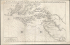
Carte Particuliere de Virginie, Maryland, Pennsilvanie, La Nouvelle Jarsey. Orient et Occidentale.
Among the Earliest Obtainable Maps of the Chesapeake.
- Digital Map Information
- Suitable for large format printing
- Full resolution TIFF file
- ICC color profile embedded
- Delivered instantly via download link
Among the Earliest Obtainable Maps of the Chesapeake.
This is Pierre Mortier and Alexis-Hubert Jaillot's c. 1700 large-format nautical chart of the Mid-Atlantic coast, including Chesapeake Bay and the Delaware River Estuary. One of the most important early modern maps of this region, it is significant for its early inclusion of Philadelphia and prodigious hydrographic information.A Closer Look
This chart is oriented towards the west, with north at the right, and covers what is now the Mid-Atlantic coast of the United States, from northern New Jersey and Staten Island in the north to the mouth of the Chesapeake Bay and the vicinity of today's Norfolk and Virginia Beach in the south. In terms of hydrography, it provides an intricate record of the Chesapeake and Delaware Bays, including rhumb lines for navigation and meticulously labeling soundings, sandbars, islands, rivers, creeks, and coastal features, including settlements. For Pennsylvania, it is especially important as one of the earliest printed maps to name the city of Philadelphia, which had been founded only a decade prior. Similarly, 'Baltimore Town' was a small, fledgling community at this time, not formally established until approximately 40 years later. The interior geography is dominated by rivers such as the Susquehanna and Potomac (Patowinack) and their tributaries, reflecting the European focus on river systems as the primary arteries for trade, particularly the fur trade with indigenous populations.Sources
Mortier and Jaillot drew on several sources to produce this chart, particularly John Thornton and William Fisher's 1689 'A New Map of Virginia, Mary-Land, Pensilvania, and New Jersey,' which explains the use of English or English transliterations of Indian words for most place names. Thornton and Fisher's map also provided the hydrographic information and the 'sideways' orientation. Additional information, particularly on terrestrial features, came from Augustine Herrman's landmark 1673 map 'Virginia and Maryland' (a primary influence on Thornton and Fisher), supplemented with more recent information, such as the inclusion of Philadelphia.Publication History and Census
This chart appeared in the Suite du Neptune François, an expanded, unofficial Amsterdam edition of the earlier Neptune François, which was produced in 1693 for the French navy and did not include this chart. Jaillot was aware of the limitations of French hydrography at the time and was impressed by Mortier's publishing enterprise, leading him to produce this 'Suite' (supplement) using the best available data, which was often English or Dutch. This map exists in only one edition and one state, published in the 'Suite' in 1700, and is therefore quite scarce, not being independently cataloged by any institution in OCLC. It is among the most desirable and earliest obtainable maps of this region and a natural centerpiece of a serious collection of maps of the mid-Atlantic / Tidewater region.Cartographers
Pierre Mortier (January 26, 1661 - February 18, 1711) or Pieter Mortier was a cartographer, engraver, and print seller active in Amsterdam during the later 17th and early 18th centuries. Mortier, then known as Pieter, was born in Leiden. He relocated to Paris from 1681 to 1685, adopting the French name Pierre, which he retained throughout his career. While in France, he developed deep French connections by bringing sophisticated Dutch printing technology and experience to nascent French map publishers such as Guillaume De L'Isle (1675 - 1726), Alexis-Hubert Jaillot (c. 1632 - 1712), and Nicholas de Fer (1646 - 1720). Consequently, much of Mortier's business was built upon issuing embellished high quality editions of contemporary French maps - generally with the permissions of their original authors. In the greater context of global cartography, this was a significant advantage as most Dutch map publishes had, at this point, fallen into the miasma of reprinting their own outdated works. By contrast, the cartographers of France were producing the most accurate and up to date charts anywhere. Mortier's cartographic work culminated in the magnificent nautical atlas, Le Neptune Francois. He was awarded the Privilege, an early form of copyright, in 1690. Upon Pierre's death in 1711 this business was inherited by his widow. In 1721, his son Cornelius Mortier took over the day to day operation of the firm. Cornelius partnered with his brother-in-law Jean Covens to form one of history's great cartographic partnerships - Covens and Mortier - which continued to publish maps and atlases until about 1866. Further Details...
Alexis-Hubert Jaillot (c. 1632 - 1712) followed Nicholas Sanson (1600 - 1667) and his descendants in ushering in the great age of French Cartography in the late 17th and 18th century. The publishing center of the cartographic world gradually transitioned from Amsterdam to Paris following the disastrous inferno that destroyed the preeminent Blaeu firm in 1672. Hubert Jaillot was born in Franche-Comte and trained as a sculptor. When he married the daughter of the Enlumineur de la Reine, Nicholas I Berey (1610 - 1665), he found himself positioned to inherit a lucrative map and print publishing firm. When Nicholas Sanson, the premier French cartographer of the day, died, Jaillot negotiated with his heirs, particularly Guillaume Sanson (1633 - 1703), to republish much of Sanson's work. Though not a cartographer himself, Jaillot's access to the Sanson plates enabled him to publish numerous maps and atlases with only slight modifications and updates to the plates. As a sculptor and an artist, Jaillot's maps were particularly admired for their elaborate and meaningful allegorical cartouches and other decorative elements. Jaillot used his allegorical cartouche work to extol the virtues of the Sun King Louis IV, and his military and political triumphs. These earned him the patronage of the French crown who used his maps in the tutoring of the young Dauphin. In 1686, he was awarded the title of Geographe du Roi, bearing with it significant prestige and the yearly stipend of 600 Livres. Jaillot was one of the last French map makers to acquire this title. Louis XV, after taking the throne, replaced the position with the more prestigious and singular title of Premier Geographe du Roi. Jaillot died in Paris in 1712. His most important work was his 1693 Le Neptune Francois. Jalliot was succeeded by his son, Bernard-Jean-Hyacinthe Jaillot (1673 - 1739), grandson, Bernard-Antoine Jaillot (???? – 1749), and the latter's brother-in-law, Jean Baptiste-Michel Renou de Chauvigné-Jaillot (1710 - 1780). Further Details...
Source
Mortier, P., Suite de Neptune François, ou atlas nouveau des cartes marines, (Amsterdam: P. Mortier) 1700.
Condition
Very good. Minor surface abrasions.
References
Morrison, R. et al, On The Map : Maryland and the Chesapeake Bay (Chestertown, MD: Washington College) 1983, fig. 23, pp. 37. Morrison, R. and Hansen, R., Charting the Chesapeake . (Maryland State Archives) 1990, pp. 19-22. Pastoureau, M., Les Atlas Français XVIe-XVIIe siècles, Jaillot I-F, 365. Shirley, R., Maps in the Atlases of the British Library, T.MORT-1a, #15.