This item has been sold, but you can get on the Waitlist to be notified if another example becomes available, or purchase a digital scan.
1893 U.S. Coast Survey Nautical Chart or Map of the Chesapeake Bay and Delaware Bay
ChesapeakeBay-uscs-1893$375.00

Title
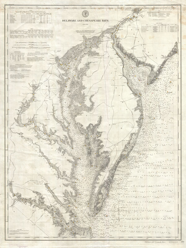
Delaware and Chesapeake Bays.
1893 (dated) 36 x 28 in (91.44 x 71.12 cm)
1893 (dated) 36 x 28 in (91.44 x 71.12 cm)
Description
This is a rare example of the 1893 U.S. Coast Survey Map or Nautical Chart of the Chesapeake Bay and Delaware Bay. This chart is based on survey work initiated in 1855 and has been updated to 1893. Covers from Philadelphia south as Cape Henry and Norfolk. Includes both the Chesapeake Bay and Delaware Bay in full, as well as significant portions of the Potomac River, Rappahannock River, York River, James River, Patapsco River, and Patuxent River. Includes the major centers of Philadelphia, Washington D.C., Wilmington, Baltimore, and Richmond. Offers stupendous detail both inland and at sea. Notes all major railroads, communities, and shoreline features. Nautically, this map really shines. There are thousands of depth soundings, shading for undersea shoals and other dangers, and red and yellow color coding for buoys, light ships, and lighthouses.
This chart is not to be confused with the similar folded charts that are commonly issued in the Annual Report of the Superintendent of the Coast Survey. Rather it is an independently issued chart on heavy stock. It has never been folded. Most likely this chart has actually been used to sail. Such charts are much less common and far more desirable than the folded Report charts. This map was published by the United States Coast and Geodetic Survey as chart no. 376 under the supervision of T. C. Mendenhall.
This chart is not to be confused with the similar folded charts that are commonly issued in the Annual Report of the Superintendent of the Coast Survey. Rather it is an independently issued chart on heavy stock. It has never been folded. Most likely this chart has actually been used to sail. Such charts are much less common and far more desirable than the folded Report charts. This map was published by the United States Coast and Geodetic Survey as chart no. 376 under the supervision of T. C. Mendenhall.
Cartographer
The Office of the Coast Survey (1807 - present) founded in 1807 by President Thomas Jefferson and Secretary of Commerce Albert Gallatin, is the oldest scientific organization in the U.S. Federal Government. Jefferson created the "Survey of the Coast," as it was then called, in response to a need for accurate navigational charts of the new nation's coasts and harbors. The spirit of the Coast Survey was defined by its first two superintendents. The first superintendent of the Coast Survey was Swiss immigrant and West Point mathematics professor Ferdinand Hassler. Under the direction of Hassler, from 1816 to 1843, the ideological and scientific foundations for the Coast Survey were established. These included using the most advanced techniques and most sophisticated equipment as well as an unstinting attention to detail. Hassler devised a labor intensive triangulation system whereby the entire coast was divided into a series of enormous triangles. These were in turn subdivided into smaller triangulation units that were then individually surveyed. Employing this exacting technique on such a massive scale had never before been attempted. Consequently, Hassler and the Coast Survey under him developed a reputation for uncompromising dedication to the principles of accuracy and excellence. Unfortunately, despite being a masterful surveyor, Hassler was abrasive and politically unpopular, twice losing congressional funding for the Coast Survey. Nonetheless, Hassler led the Coast Survey until his death in 1843, at which time Alexander Dallas Bache, a great-grandson of Benjamin Franklin, took the helm. Bache was fully dedicated to the principles established by Hassler, but proved more politically astute and successfully lobbied Congress to liberally fund the endeavor. Under the leadership of A. D. Bache, the Coast Survey completed its most important work. Moreover, during his long tenure with the Coast Survey, from 1843 to 1865, Bache was a steadfast advocate of American science and navigation and in fact founded the American Academy of Sciences. Bache was succeeded by Benjamin Pierce who ran the Survey from 1867 to 1874. Pierce was in turn succeeded by Carlile Pollock Patterson who was Superintendent from 1874 to 1881. In 1878, under Patterson's superintendence, the U.S. Coast Survey was reorganized as the U.S. Coast and Geodetic Survey (C & GS) to accommodate topographic as well as nautical surveys. Today the Coast Survey is part of the National Oceanic and Atmospheric Administration or NOAA as the National Geodetic Survey. More by this mapmaker...
Condition
Good. Some minor soiling along top margin. Minor cosmetic damage near Philadelphia. We considered having this map professionally cleaned and flattened, but find that it is quite nice as is. However, this service remains an option for the buyer. On thick stock.
References
Swem, E. G., Maps Relating to Virginia in the Virginia State Library and other Departments of the Commwealth with the 17th and 18th Century Atlas-Maps in the Library of Congress, 1561.