1897 Garcia Cubas and Vega Map of Chiapas, Mexico
Chiapas-garciacubas-1897$800.00

Title
Chiapas.
1897 (dated) 15.25 x 17.75 in (38.735 x 45.085 cm) 1 : 1200000
1897 (dated) 15.25 x 17.75 in (38.735 x 45.085 cm) 1 : 1200000
Description
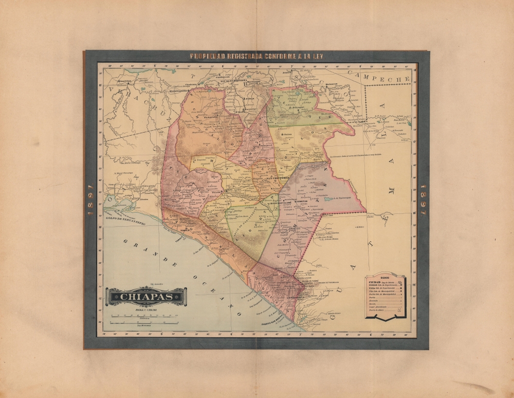
A rare 1897 color lithograph map of Chiapas by Antonio García Cubas, published by Vega y Cie for the Atlas Geográfico de los Estados Unidos Mexicanos. It depicts the state as it was transitioning towards cash crop production on large plantations, fundamentally altering the region's economy and society.
However, these reforms - especially increased agricultural production on large plantations - relied on the inexpensive labor of indigenous peoples, who worked in inhumane conditions and were often lured into debt bondage or unfair contracts (in the mid-19th century, most communally-held indigenous lands and Church property were sold off and transferred to cash crop production). Local uprisings followed, and the continued struggle between landowners and agricultural laborers (generally paralleling conflict between indigenous people on the one hand and whites and mestizos on the other, and between left-wing and right-wing political movements) defined politics in the state for decades afterwards, arguably down to the present.
A Closer Look
The entire state of Chiapas is displayed, divided into departamentos. This and other maps by García Cubas are notable for employing Mexico City as the Prime Meridian. Rivers, lakes, mountains, roads, administrative boundaries (including the border with Guatemala, only finalized in 1882), cities, pueblos, ranchos, haciendas, and 'abandoned places' are indicated. The road from San Cristobal to Oaxaca was a recent construction, providing the first reliable land route between the two states.Land and Labor in Chiapas
Chiapas was undergoing drastic changes at this time, under the administration of Governor Emilio Rabasa (1891 - 1895) and other reformists of the Porfiriato era. The capital was moved to Tuxtla (now Tuxtla Gutiérrez) in 1892, a change not reflected here as García Cubas' original map was produced in 1887. Additional highways, port facilities (at Tonalá), and other infrastructure were built, education expanded, and policies put in place to consolidate and rationalize agricultural production, with coffee becoming a major export in these years.However, these reforms - especially increased agricultural production on large plantations - relied on the inexpensive labor of indigenous peoples, who worked in inhumane conditions and were often lured into debt bondage or unfair contracts (in the mid-19th century, most communally-held indigenous lands and Church property were sold off and transferred to cash crop production). Local uprisings followed, and the continued struggle between landowners and agricultural laborers (generally paralleling conflict between indigenous people on the one hand and whites and mestizos on the other, and between left-wing and right-wing political movements) defined politics in the state for decades afterwards, arguably down to the present.
Publication History and Census
This map was published in Mexico City in 1897 by Vega y Cie and was printed by Lit. Montauriol Sucs., Mexico City. It is based on the 1887 work of Antonio García Cubas and was updated with additional border work for the 1897 issue of the Atlas Geográfico de los Estados Unidos Mexicanos. As with other maps in the 1897 reissue, the original publication information just outside the neatline has been obscured by a thick black border. The atlas is represented in several institutional collections but is extremely scarce on the market. The individual maps, likewise, are scarce to the market.Cartographer
Antonio Garcia y Cubas (July 24, 1832 - February 9, 1912) was a Mexican cartographer, writer, engineer, and geographer active in Mexico City in the second half of the 19th and the early 20th centuries. He is considered Mexico's first great geographer. Garcia y Cubas was born in Mexico City. He was orphaned at birth and was raised by is aunt. When he turned 18, he enrolled in the Dirección General de Industria, a government sponsored technical school. There he studied engineering and geography, which he further pursued at the Colegio de San Gregorio, Colegio de Ingenieros. He graduated with honors in geography and from 1856, became a member of the Sociedad Mexicana de Geografía y Estadística. His geographical work earned him the Order of Guadalupe, a Mexican second empire honorific, directly from the Emperor Maximillian. He published several atlases, including his important Atlas Geográfico, Estadístico e Histórico de la República Mexicana, and multiple decorative chromolithograph Atlas Pintoresco e Históricos covering Mexico, Cuba, Spain, and elsewhere. Today his work is scarce and highly desirable. More by this mapmaker...
Source
García Cubas, Antonio, Atlas Geográfico de los Estados Unidos Mexicanos, (Mexico City: Vega) 1897.
Atlas Geográfico de los Estados Unidos Mexicanos is a grand-format folio atlas of Mexico. It is based largely upon the Atlas Geográfico y Estadístico de los Estados Unidos Mexicanos published in 1887 by Antonio García Cubas and Debray. The present atlas incorporates the same maps, but adds a dramatic silver and gold border, which obscures the 1886 García Cubas imprint. It was issued during Porfirio Díaz's third term as president of Mexico - a period marked by rapid expansion of infrastructure and industry, including railroads, mines, bridges, roads, and broad scale electrification and waterworks. The atlases title page in this 1897 edition, celebrates Diaz with a large portrait and dedication. We have identified at least two editions of this atlas, both bearing the 1897 date: one by Cadena y Cie, features a red title page, another by Vega y Cie, featuring a blue title page. All 1897 editions we have identified have the silver borders, but these seem to be overprinted to cover an earlier gold border, with unidentifiable text and dating behind. We have been unable to find any examples with only the gold border. The atlases in general are showpieces of Mexican lithography in the golden age of the Porfiriato.
Condition
Very good. Even overall toning. Crease and light foxing along centerfold. Size referenced is the printed map; wide borders add several inches to all sides.
References
cf. Rumsey 5758.016 (1886).