This item has been sold, but you can get on the Waitlist to be notified if another example becomes available, or purchase a digital scan.
1920 Cram Map or City Plan of Chicago, Illinois
Chicago-cram-1920$175.00

Title
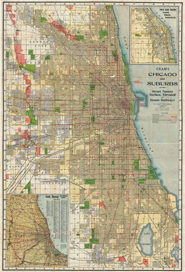
Cram's Chicago and Suburbs.
1920 (undated) 44 x 30 in (111.76 x 76.2 cm) 1 : 102960
1920 (undated) 44 x 30 in (111.76 x 76.2 cm) 1 : 102960
Description
This is a large 1920 map or city plan of Chicago, Illinois by G. F. Cram. This enormous pocket map was issued as a tourist guide and depicts the city of Chicago and its suburbs in great detail. It covers from Park Ridge south as far as Lake Calumet and from La Grange Park east as far as Wolf Lake and Lake Michigan. The map is exceptionally detailed, noting individual streets, parks, rivers, lakes, cemeteries, house numbers as well as surface, elevated and steam railroads. An inset of the North Shore Suburbs of Evanston, Wilmette, Kenilworth, etc. is included in the upper right quadrant. The lower left quadrant features another inset of Cook, Dupage and adjoining counties along with an index.
Selected as a railway hub for most of the American Midwest, Chicago underwent a boom period and was the focus of the world's attention in 1893 during the Chicago World's Fair, or as it is better known, the Columbian Exposition. The map identifies Jackson Park, the location of the fair. It also illustrates the Chicago Park System. The 'Park System,' designed by Olmsted prodigy William Le Baron Jenny in 1871, refers to a network of parks and garden boulevards intended to embrace the city in arms of foliage. Many of these parks and boulevards remain today.
The map is accompanied by a 32 page city and suburban street index guide. The map was issued by the George F. Cram Company, Chicago.
Cartographer
George Franklin Cram (May 20, 1842 - 1928) was an American map publisher active in the late 19th and early 20th centuries. During the American Civil War, Cram served as a staff cartographer for the Union General Ulysses S. Grant and participated in Sherman's 'March to the Sea'. In 1867, after being discharged from the army, George Cram moved to Chicago, where he founded 'Blanchard and Cram' with his uncle Rufus Blanchard Evanston. Blanchard and Cram was a supply house for the book trade - though they also published a few maps during this period. This short lived business was destroyed in the 1871 by the Great Chicago Fire. After the fire, recognizing a business opportunity in the burgeoning railroad industry, Cram reinvented himself as cartographic publisher, opening the Cram Map Depot. Like fellow Chicago publisher Rand McNally, Cram took advantage of the economical wax engraving processes to inexpensively produce maps in vast quantities. His signature publication, the Unrivaled Atlas of the World became the world's best-selling atlas and was published from the 1880s to 1952. On retiring in 1921, Cram sold his company to Edward A. Peterson of the National Map Company (Scarborough Company). Peterson moved the company to Indianapolis where, following Cram's death, he rebranded the National Map Company as the George F. Cram Company, surely thinking to capitalize on the established identity of the firm. In 1930 he entered the globe market for which the firm was best known from the mid-20th century. In time the firm expanded globally passing becoming a major concern. Loren B. Douthit became company president in 1968 and the Douthit family ran the business until Herff Jones, Inc., bought the company in 2005. More by this mapmaker...
Condition
Very good. Some wear along original fold lines. Minor loss over fold intersections. Professionally flattened and backed with archival tissue. Accompanied by street index guide.