This item has been sold, but you can get on the Waitlist to be notified if another example becomes available, or purchase a digital scan.
1898 Rand McNally Map of the United States w/ Chicago and Alton Railroad
ChicagoAltonRR-randmcnally-1898$400.00

Title
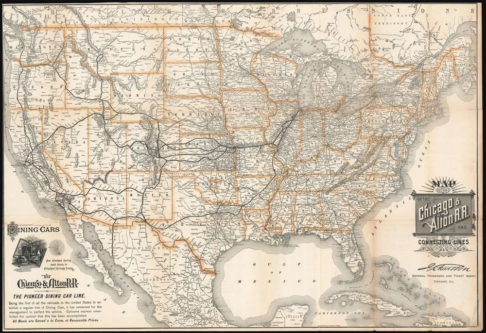
Map of the Chicago and Alton R.R. and Connecting Lines.
1898 (dated) 24 x 35.25 in (60.96 x 89.535 cm) 1 : 5650000
1898 (dated) 24 x 35.25 in (60.96 x 89.535 cm) 1 : 5650000
Description
This is an 1898 Rand McNally map of the United States published for the Chicago and Alton Railroad. The Chicago and Alton's main line from Chicago to Alton, Illinois (on the Missouri River) and its extensions to St. Louis and Kansas City are boldly highlighted in black. Each stop along these lines are labeled. The major stops, Springfield, Bloomington, Peoria, St. Louis, and Kansas City, are identified. Connection on the Union Pacific, Missouri Pacific, Atchison, Topeka, and Santa Fe, and Southern Pacific Railroads are highlighted in bold. Innumerable other railroads are also illustrated.
'Unassigned Lands' or 'Oklahoma Country'
The terms 'Unassigned Lands' and 'Oklahoma Country' were used interchangeably in the 1880s to describe the last parcel of land not 'assigned' to an Indian tribe in the Indian Territory (the modern-day state of Oklahoma). In 1879, in an article in the Chicago Times, mixed-blood Cherokee Elias C. Boudinot became the first to use of the term 'Unassigned Territory' in popular usage. The boundaries of his 'Unassigned Territory' were established by treaties signed between the United States and various Indian tribes. All in all, the 'Oklahoma Country' covered approximately 2,950 square miles. Five rivers crossed the territory, timber was plentiful, and in 1866 the Santa Fe Railway laid their north-south line through the 'Unassigned Lands'.'Sooners' and the Oklahoma Land Run
By 1880, so-called 'boomers' (white settlers) started trying to stake claims in 'Oklahoma Country' but were generally evicted by the U.S. cavalry. In 1889, Congress passed an amendment to the Indian Appropriations Act of 1871 allowing white settlement in the 'Oklahoma Country' beginning with an April 22 'land run. This became the famous 'Land Run of 1889', the first land run in the territory's history, and the legend of the 'Sooners' (those who entered the Oklahoma Territory before noon on April 22) was born.The Chicago and Alton Railroad
The Chicago and Alton Railroad is most remembered as the railroad to operate the first sleeping car designed by George Pullman, built in the Chicago and Alton's shops in Bloomington and introduced on September 1, 1859. The Chicago and Alton was also the first railroad to operate a dining car, also built by Pullman. The railroad inaugurated three dining cars at once, on each of their three principal trains, launching an 'arms race' in dining car luxury. The Chicago and Alton Railroad was chartered as the Alton and Sangamon Railroad on February 27, 1847, to connect Alton with Springfield, the state capital. Work was completed in 1852, and in 1854, then known as the Chicago and Mississippi Railroad, the line was extended to Bloomington. In 1855, it was extended again, this time to Joliet. From Joliet, trains operated on the completed Chicago and Rock Island Railroad to Chicago. Chartered February 15, 1855, the Joliet and Chicago Railroad opened in 1856 and connected Joliet with downtown Chicago and was leased to the Chicago and Mississippi. The Chicago and Mississippi was reorganized as the St. Louis, Alton and Chicago railroad in 1857, and, in 1862, the Chicago and Alton Railroad emerged from yet another reorganization. The Chicago and Alton operated until 1931, when it was purchased by the Baltimore and Ohio Railroad and renamed the Alton Railroad. The Alton Railroad merged with the Gulf, Mobile and Ohio Railroad on May 31, 1947, ending its existence.Publication History and Census
This map was created and published by Rand McNally for the Chicago and Alton Railroad in February 1898. Two examples are cataloged in OCLC and are part of the institutional collections at Harvard University and the Kansas City Public Library.Cartographer
Rand, McNally and Co. (fl. 1856 - present) is an American publisher of maps, atlases and globes. The company was founded in 1856 when William H. Rand, a native of Quincy, Massachusetts, opened a print shop in Chicago. Rand hired the recent Irish immigrant Andrew McNally to assist in the shop giving him a wage of 9 USD per week. The duo landed several important contracts, including the Tribune's (later renamed the Chicago Tribune) printing operation. In 1872, Rand McNally produced its first map, a railroad guide, using a new cost effective printing technique known as wax process engraving. As Chicago developed as a railway hub, the Rand firm, now incorporated as Rand McNally, began producing a wide array of railroad maps and guides. Over time, the firm expanded into atlases, globes, educational material, and general literature. By embracing the wax engraving process, Rand McNally was able to dominate the map and atlas market, pushing more traditional American lithographic publishers like Colton, Johnson, and Mitchell out of business. Eventually Rand McNally opened an annex office in New York City headed by Caleb S. Hammond, whose name is today synonymous with maps and atlases, and who later started his own map company, C. S. Hammond & Co. Both firms remain in business. More by this mapmaker...
Condition
Good. Verso reinforcements at fold intersections. Closed margin tears professionally repaired on verso. Closed tear extending 2.5 inches along right border in Atlantic Ocean. Left and top margin cut to border in places. Railroad timetables on verso.
References
OCLC 60502993.