This item has been sold, but you can get on the Waitlist to be notified if another example becomes available, or purchase a digital scan.
1945 U.S. Hydrographic Nautical Map of Chimu Wan, Okinawa
ChimuWan-hydrographicoffice-1945$250.00

Title
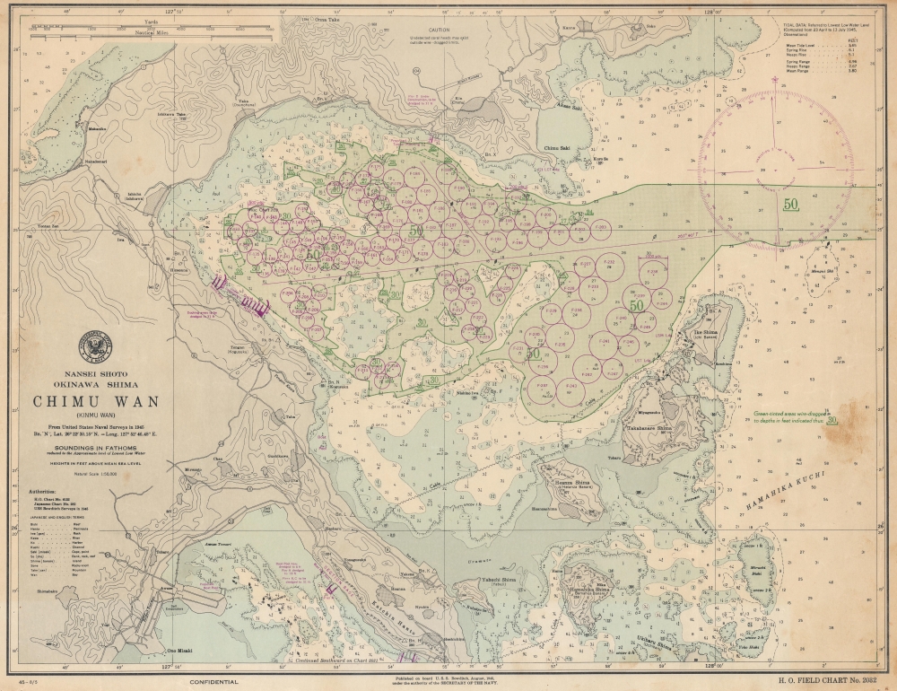
Nansei Shoto. Okinawa Shima. Chimu Wan (Kinmu Wan).
1945 (dated) 16.75 x 21.5 in (42.545 x 54.61 cm) 1 : 50000
1945 (dated) 16.75 x 21.5 in (42.545 x 54.61 cm) 1 : 50000
Description
This is a 1945 U.S. Navy Hydrographic Office nautical chart or map of Chimu Wan, Okinawa, illustrating preparations for Operation Downfall, the planned invasion of Japan's Home Islands, through an ongoing naval buildup. Significantly, this is one of the few surviving charts published on board the U.S.S. Bowditch. It is poignant that the last update on this map is August 5, the day before the first atomic bomb was dropped on Hiroshima, underscoring uncertainty surrounding the war's potential end.
A Closer Look
Centered on Kin Bay, the Katsuren Peninsula appears at bottom center and Heanza, Takabanare, and Ike islands are labeled to the right of the peninsula. Kin Bay is filled with berths, identified by alphanumeric designations (F-238 for example). Every berth appears as a circle, with diameters designating various classes of ship. The green shaded areas have been wire-dragged to given depths. The Chimu Airfield is situated at top center just below a note cautioning that coral heads may exist outside the wire-dragged areas. This airfield was used by the U.S. Navy following the battle of Okinawa. Purple docks appear in three locations around Kin Bay and on the south side of the Katsuren Peninsula, illustrating the significant construction the U.S. Navy completed after securing Okinawa.The U.S.S. Bowditch
The U.S.S. Bowditch began as the Santa Inez, a Danish passenger ship launched in 1929 by Burmeister and Wain. The U.S. Navy purchased the Santa Inez on March 4, 1940, after which she received a temporary commission. She was sent to the Norfolk Navy Yard, outfitted as a survey ship, and renamed the U.S.S. Bowditch. Bowditch undertook several geodetic survey missions in the Caribbean before leaving Norfolk in January 1942 for South America and the Pacific. After returning in Norfolk for repairs in November 1942, she returned to the Pacific in February 1943, where she remained until she was assigned to the Service Force, Pacific Fleet. Bowditch arrived in Pearl Harbor on January 6, 1944, and participated as a survey ship during the invasion of Kwajalein and Majuro Atolls (February 4 - April 2, 1944), the occupation of Saipan (July 22 - October 4, 1944) and the capture of Okinawa (April 18 - September 2, 1945). Bowditch helped rescue survivors of the U.S.S. Montgomery and the U.S.S. Force during her time off Okinawa. She left Okinawa on November 3, 1945, and returned to the United States. Bowditch took part in the preliminary surveys of Bikini Atoll for Operation Crossroads, leaving San Francisco on February 17, 1946. She remained in Bikini after the atomic bomb tests and finally returned to San Francisco on October 19, 1946. She was decommissioned at Norfolk on January 31, 1947, and transferred to the Maritime Commission on June 9, 1948.Publication History and Census
This map was compiled from U.S. Navy Hydrographic Chart No. 6132, Japanese Chart No. 282, and surveys conducted by the U.S.S. Bowditch in 1945 and published on board the U.S.S. Bowditch in August 1945 with corrections up to August 5 as Hydrographic Office Field Chart No. 2032. This is the only known surviving example of this chart and one of four known surviving cataloged charts that were printed on board the U.S.S.Bowditch during World War II.Cartographer
United States Hydrographic Office (1866 - 1962) was a brach of he U.S. Navy that prepared and published maps, charts, and nautical books to aid in navigation. Before the establishment of the Hydrographic Office in 1866, U.S. navigators were almost entirely dependent on British charts. There had been a few private enterprises that had prepared and published charts, but none had been able to do so profitably. The Office was established 'for the improvement of the means of navigating safely the vessels of the Navy and of the mercantile marine, by providing, under the authority of the Secretary of the Navy, accurate and cheap nautical charts, sailing directions, navigators, and manuals of instructions for the use of all vessels of the United States, and for the benefit and use of navigators generally.' This way the Navy Department could furnish navy and merchant ships with charts illustrating the results of surveys and explorations undertaken by naval officers. The charts were priced to cover the cost of paper and printing alone, not preparation. Its main objective was to survey foreign coasts, as the Coast and Geodetic Surveys were responsible for surveying domestic waters. The Hydrographic Office was transferred from the Department of the Navy to the Department of Defense in 1949 and was replaced by the Naval Oceanographic Office in 1962. More by this mapmaker...
Condition
Very good. Pinholing likely from staples in corners and in four places in parallel line in bottom quarter.