This item has been sold, but you can get on the Waitlist to be notified if another example becomes available, or purchase a digital scan.
1844 Black Map of China
China-black-1844$75.00

Title
China.
1844 (undated) 11.5 x 16 in (29.21 x 40.64 cm) 1 : 8550000
1844 (undated) 11.5 x 16 in (29.21 x 40.64 cm) 1 : 8550000
Description
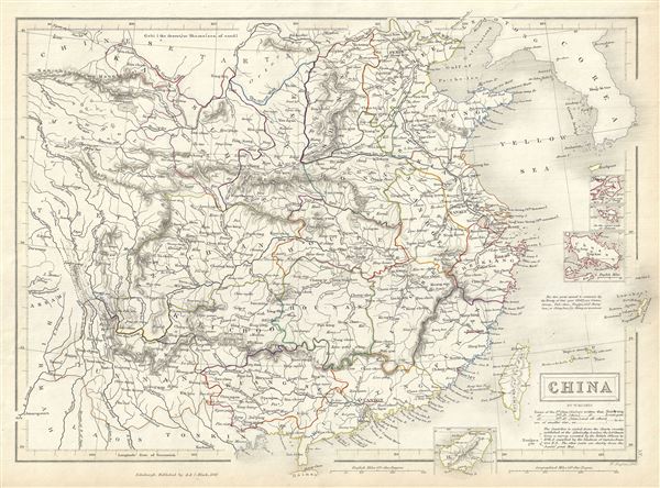
This is a fine example of Adam and Charles Black's 1844 map of China. The map covers China from the Chinese Tartary to Hainan and from Assam in India to Korea (Corea), inclusive of Formosa or Taiwan. Four inset maps detail Amoy, Hong Kong, Zhoushan and Hainan. The Great Wall of China is identified. Taiwan or Formosa is mapped vaguely, representing the poor knowledge of the region prior to the Japanese invasion and subsequent survey work in 1895. The map identifies both Hong Kong and Macao. Throughout, the map identifies various cities, towns, rivers, mountain passes and an assortment of additional topographical details.
Black's map reveals China just a after the First Opium War. In the early 19th century Asia was increasingly coming under imperial European sway. By the 1830s, oversaturation of the Chinese market slackened Chinese demand for most British products. To make up for the trade deficit, British merchants introduced Indian opium to China. Addictive and cheap, Opium became Britain's most profitable and important crop in world markets, pouring into China faster than tea poured into Britain. Opium addiction and its attendant social ills reached such catastrophic levels that the Chinese government took action and destroyed British opium stores in Canton. As this threatened English commercial interests, the crown responded, sparking the Opium Wars of 1839-1842. The superior British forces took complete control of Canton, occupied Shanghai, and blockaded Chinese ports, forcing the Chinese to sign the 1842 Treaty of Nanking. This unequal treaty (the first of many between European powers and China) would grant Britain extensive trading rights in China.
The map is engraved by W. Hughes and issued as plate no. LV in the 1844 edition of Black's General Atlas.
CartographerS
Charles and Adam Black (fl. 1807 - present) were map and book publishers based in Edinburgh. Charles and his uncle, Adam, both of Edinburgh, Scotland, founded their publishing firm in 1807. They published a series of maps and atlases throughout the 19th century. In addition to an array of atlases, the Black firm is known for their editions of the Encyclopedia Britannica (1817 - 1826) and the first publishing of Sir Walter Scott's novels in 1854. In 1889 the A. & C. Black publishing house moved to London where it remains in operation to this day. More by this mapmaker...
William Hughes (c. 1818 - May 21, 1876) was a cartographer, engraver, lithographer, printer, and publisher active in London during the middle part of the 19th century. Hughes enjoyed and long and varied cartographic career. He was elected a Fellow of the Royal Geographical Society in 1838 and, from about 1840, taught geography and mapmaking at St. Johns College for Civil Engineers. He later taught the same at both Queens College and Kings College, London. For a time he was employed as a map librarian for the British Museum. Hughes began engraving maps around 1839 and worked with most of the prominent British map and atlas publishers of his era, including but not limited to Charles Knight, A. and C. Black, George Philip, William Cassell, and others. Learn More...
Source
Black, A. and C., Black's General Atlas (Edinburgh), 1844.
Black's General Atlas was a popular Scottish atlas of the world issued by the Edinburgh firm of Adam and Charles Black. This atlas was first issued in 1840 with subsequent editions being printed well into the 1890s. While most editions were printed in Edinburgh, an American edition was issued in 1857. Most early editions of his atlas were engraved by S. Hall. Typically this refers to Sidney Hall, who died in 1831, but in this case, since the engraving was initiated well after his death, it was most likely his widow, Selina Hall, who did the engraving. Later editions feature additional maps updated and engraved by William Hughes. Early editions featured outline color only, but later editions embraced a full color approach with pale green, yellow, and blue pastels. All editions are known for their meticulous presentation of the most up-to-date cartographic information. Moreover, this exceptionally long publication run provides a fine cartographic record of the middle to late 19th century - particularly as regards the complex cartographic evolution of the Americas through this period.
Condition
Very good. Original platemark visible. Blank on verso.