This item has been sold, but you can get on the Waitlist to be notified if another example becomes available, or purchase a digital scan.
1747 Kitchin Map of China
China-kitchin-1747$175.00

Title
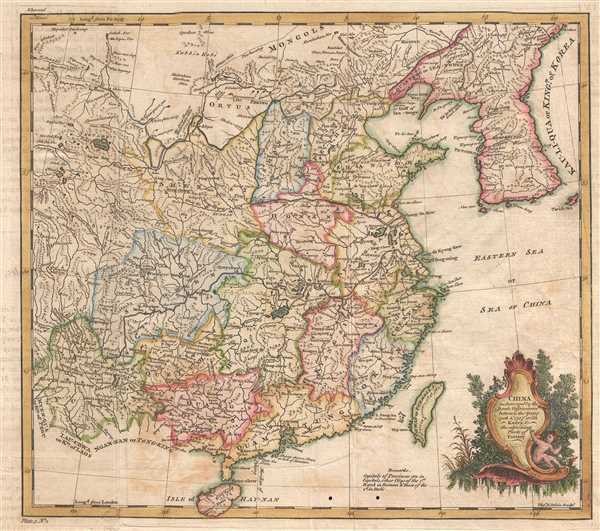
China as Surveyed by the Jesuit Missionaries between the Years 1708 and 1717 with Korea and the ajoining Parts of Tartary.
1747 (undated) 11.75 x 13.25 in (29.845 x 33.655 cm) 1 : 10000000
1747 (undated) 11.75 x 13.25 in (29.845 x 33.655 cm) 1 : 10000000
Description
This is a 1747 Thomas Kitchin map of China. The map depicts the region from Yunnan to the East China Sea and from Mongolia and Korea to Hainan. Exquisitely engraved, myriad cities, towns, and villages throughout China are labeled, including Beijing (Peking), Guangzhou (Canton), and Nanjing (Nan-King). The Great Wall of China is also illustrated traversing northern China near Beijing. Cartographically, the map is based on early maps by Jean Baptiste Bourguignon d'Anville, note in particular D'Anville's characteristic shaping of the Korean Peninsula. The Kingdom of Korea is also labeled Lau-Li-Qua, which is quite unusual. The body of water east of Korea remains unlabeled, which is significant as there is a debate between naming it the East Sea, the Sea of Korea, or the Sea of Japan. Curiously, here the Eastern Sea is labeled, but further to the south as part of the East China Sea, which today is not part of this dispute.
This map was created by Thomas Kitchin and published in 1747.
Jesuit Mapping of China
The Qing Emperor Kangxi commissioned a ground of Jesuit surveyors to map China from 1708 to 1716. The resulting maps were published as the Kangxi Atlas (1718-19). The leading French cartographer Jean-Baptiste Bourguignon D'Anville (1697-1782), acquired copies of the Kangxi maps, which were first printed in Jean-Baptiste Du Halde's Description Geographique … de la Chine (Paris, 1735).This map was created by Thomas Kitchin and published in 1747.
Cartographer
Thomas Kitchin (August 4, 1718 – June 23, 1784) was a London based engraver, cartographer, and publisher. He was born in London to a hat-dyer of the same name. At 14, Kitchin apprenticed under Emanuel Bowen, under whom he mastered the art of engraving. He married Bowen daughter, Sarah Bowen, and later inherited much of his preceptor's prosperous business. Their son, Thomas Bowen Kitchin, also an engraver joined the family business, which thereafter published in Thomas Kitchin and Son. From 1858 or so Kitchin was the engraver to the Duke of York, and from about 1773 acquired the title, 'Royal Hydrographer to King George III.' He is responsible for numerous maps published in the The Star, Gentleman's Magazine, and London Magazine, as well as partnering with, at various times, with Thomas Jefferys, Emmanuel Bowen, Thomas Hinton, Issac Tayor, Andrew Dury, John Rocque, Louis de la Rochette, and Alexander Hogg, among others. Kitchin passed his business on to his son, Thomas Bowen Kitchin, who continued to republish many of his maps well after his death. Kitchin's apprentices included George Rollos, Bryant Lodge, Thomas Bowen Kitchin, Samuel Turner Sparrow, John Page, and Francis Vivares. More by this mapmaker...
Condition
Good. Exhibits transference. Verso repairs to fold separations. Blank on verso.
References
OCLC 316356780.