
1656 / 1679 Sanson Map of China and Korea

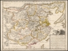
La Chine Royaume.
Jesuit knowledge of the China and Korea.
- Digital Map Information
- Suitable for large format printing
- Full resolution TIFF file
- ICC color profile embedded
- Delivered instantly via download link
Jesuit knowledge of the China and Korea.
This is Nicolas Sanson's 1656 map of China and Korea, here in its 1679 edition published by Sanson’s son, Guillaume Sanson. Although Sanson credits a notional 'Matheo Neroni' as his source, it is almost certainly Matteo Ricci, the Jesuit missionary and cosmographer, who composed an important map in 1588 based on Chinese sources. The map is notable for its unusual, sickle-shaped mapping of Korea, resulting from Ricci’s attempts to reconcile Chinese sources.A Closer Look
Coverage embraces the Chinese Empire from Qinghai Lake (Lago Sinsiuch) to Korea (Corea), and from Mongolia to the border with Vietnam. It is divided into the 13 traditional Ming provinces. The Great Wall appears prominently. Coverage extends to include northern Luzon, the Philippines, and a remarkable, sickle-shaped Korean Peninsula. Taiwan is named as 'I. Hermosa,' an early form of 'Formosa'. In the south, the detailed content terminates with the Red River (Kinxa Fl.) and the border with Vietnam (Cachucyna). Just beyond, Hanoi is identified as Dumoquin (Tonquin).The Source
The map's text describes the source for this map as a wall map in the possession of one 'Matheo Neroni' derived from a work drawn in Rome in 1590 and with explanations from Michel Ruggieri. Sanson did not and could not have known Ruggieri, who died in 1607, and there is no evidence to suggest that 'Matheo Neroni' existed at all. Szcześniak, in his 1954 Imago Mundi article, suggests that 'Neroni' was in fact Matteo Ricci, and that the map was not drawn in Rome in 1590 but brought there from China in that year, having been composed by Ricci in China based on Chinese sources.Korea
The maps Ricci had access to disagreed on the disposition of the Liaodong Peninsula, none of them showing it with precision; they also were imprecise on the depiction of Korea. The portrayal of Korea here, preserved by Sanson in a uniquely sweeping, curvilinear shape, is the result of Ricci's effort to synthesize the disparities in his sources. Many early maps excised Korea entirely; others placed it too far west (by ignoring Liaodong, or conflating the two). The Ricci/Sanson map is remarkable for presenting both, despite distorting their shapes.Publication History and Census
This map was first engraved by Johannes Somer in 1656 for inclusion in Sanson's atlas, published two years later by Pierre Mariette. There are three or four states of this map, of which this is probably the last: although still bearing Nicolas Sanson's imprint, the Galleries du Louvre address and date of 1679 correspond to the editions being published at that time for the Atlas général of Nicolas' son, Guillaume Sanson. The present example, mounted as it is on old linen, may have been separately issued, or tipped into an atlas factice. OCLC records seven examples of this state of the map.Cartographers
Nicolas Sanson (December 20, 1600 - July 7, 1667) and his descendants were the most influential French cartographers of the 17th century and laid the groundwork for the Golden Age of French Cartography. Sanson was born in Picardy, but his family was of Scottish Descent. He studied with the Jesuit Fathers at Amiens. Sanson started his career as a historian where, it is said, he turned to cartography as a way to illustrate his historical studies. In the course of his research some of his fine maps came to the attention of King Louis XIII who, admiring the quality of his work, appointed Sanson Geographe Ordinaire du Roi. Sanson's duties in this coveted position included advising the king on matters of geography and compiling the royal cartographic archive. In 1644, he partnered with Pierre Mariette, an established print dealer and engraver, whose business savvy and ready capital enabled Sanson to publish an enormous quantity of maps. Sanson's corpus of some three hundred maps initiated the golden age of French mapmaking and he is considered the 'Father of French Cartography.' His work is distinguished as being the first of the 'Positivist Cartographers,' a primarily French school of cartography that valued scientific observation over historical cartographic conventions. The practice result of the is less embellishment of geographical imagery, as was common in the Dutch Golden Age maps of the 16th century, in favor of conventionalized cartographic representational modes. Sanson is most admired for his construction of the magnificent atlas Cartes Generales de Toutes les Parties du Monde. Sanson's maps of North America, Amerique Septentrionale (1650), Le Nouveau Mexique et La Floride (1656), and La Canada ou Nouvelle France (1656) are exceptionally notable for their important contributions to the cartographic perceptions of the New World. Both maps utilize the discoveries of important French missionaries and are among the first published maps to show the Great Lakes in recognizable form. Sanson was also an active proponent of the insular California theory, wherein it was speculated that California was an island rather than a peninsula. After his death, Sanson's maps were frequently republished, without updates, by his sons, Guillaume (1633 - 1703) and Adrien Sanson (1639 - 1718). Even so, Sanson's true cartographic legacy as a 'positivist geographer' was carried on by others, including Alexis-Hubert Jaillot, Guillaume De L'Isle, Gilles Robert de Vaugondy, and Pierre Duval. Further Details...
Matteo Ricci (October 6, 1552 - May 11, 1610), was an Italian Jesuit priest noted for his work in establishing the first Jesuit China missions. In the mapmaking world, he represented a conduit of cartographic information - both from Europe to China, introduced the findings of European exploration to a Chinese audience, and from China to Europe, supplying some of the best early maps of China to a Western audience starved of data for the interior of the Chinese Empire. Ricci was born in Macerata in the Papal States of Italy, received his first education there and went on to study law in Rome. While there, he studied philosophy, theology, mathematics, cosmology, and astronomy under the direction of Christopher Clavius. In 1571 he entered the Society of Jesus. In 1577 he would apply to begin missionary work, first to Goa from 1578 to 1582, and then to Macau and China. He was among the first Europeans to study Chinese language and customs, and one of the first western scholars to master Chinese characters and classical Chinese. Accompanied by Michele Ruggieri, he travelled to Canton and then to Zhaoqing, where he would stay from 1583 to 1589 as a guest of the governor Wang Pan. It was here that Ricci produced the first Chinese-Language map based on European geographical knowledge, called 'Complete Map of the Great World' (Da Ying Quan Tu, 大瀛全圖). Ricci and Ruggieri also compiled the first dictionary of Chinese in any European language. He would become the first European to enter the Forbidden City of Beijing in 1601 when invited by the Wanli Emperor, who sought his services in matters such as court astronomy and calendrical science. Further Details...
Source
Sanson, N., Cartes generales de toutes les parties du monde, ou les empires, monarchies, republiques, estats, peuples, et c. de l'Asie, de l'Afrique, de l'Europe, et de l'Americque, tant anciens que nouveaux, sont exactement remarqués, et distingués suivant leur estenduë, (Paris: Mariette) 1658.
Condition
Very good. Some areas of scuffing. Backed on old linen, probably contemporaneously with the printing and coloring of the map. Contemporary outline color.
References
Rumsey 9741.123 OCLC 15670266. Szcześniak, Boleslaw, 'Matteo Ricci's Maps of China.' Imago Mundi, vol. 11, 1954, pp. 127–136.