1729 Stoecklein / Nolin Map of China
China-stocklein-1729$550.00
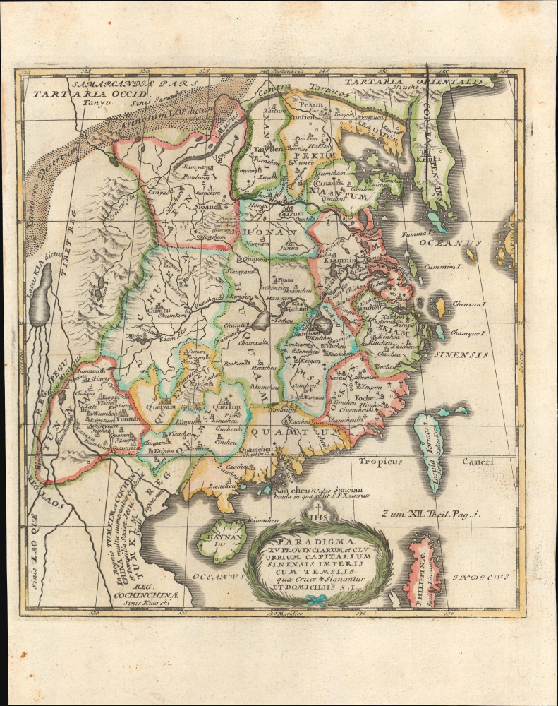

Title
Paradigma XV Provinciarum et CLV Urbium Capitalium Sinensis Imperij Cum Templis quae Cruce X Signatur Et Domiciliis S.I.
1729 (undated) 8.75 x 8 in (22.225 x 20.32 cm) 1 : 13000000
1729 (undated) 8.75 x 8 in (22.225 x 20.32 cm) 1 : 13000000
Description
This is Joseph Stöcklein's c. 1729 map of China, prepared for his Der Neue Welt-bott. It was an important piece of early cultural exchange between China and Europe, which helped spur the Enlightenment.
The Jesuits' translation of Chinese thought for a European audience had a notable impact. European intellectuals were deeply curious about China and often incorporated the information they received about it into their developing thought systems. For instance, Voltaire saw China as an ideal secular state, unencumbered by religious superstition and driven by rationality and ethics, Leibniz viewed ancient Chinese civilization, particularly the Yijing, as an antecedent to his own mathematical and philosophical system, and the French physiocrats looked to China as a model for an agrarian economic system.
A Closer Look
This map covers the provinces of 'China Proper,' consistent with the territory of the Ming Dynasty, which was deposed and replaced by the Manchu Qing Dynasty in 1644. Provinces are outlined in hand color, with mountains, major waterways, and large cities noted with Latinized placenames: Pekim (Beijing), Quamcheu (Guangzhou), Sigan (Xi'an), and so on. The sites of Jesuit missions and churches, including three in Beijing, are recorded with crosses. Around the perimeter of China, the Gobi Desert, the Great Wall of China, neighboring kingdoms, and the location of the death of Francis Xavier on the coastal island of Shangchuan (Sancian) are indicated, as is the location of an 8th-century Nestorian Stele discovered in Shanxi Province in 1625, tracing the early history of Christianity in China. South of China, Tonkin and Cochinchina are noted as having many Jesuits.Early Jesuit Missions to China
Jesuit missionaries arrived in China in the early seventeenth century and were generally distrusted due to their foreign religion, but were allowed to stay in Beijing and several other cities, construct churches and render services that the emperor and his advisors deemed useful. In particular, the Jesuits were great mathematicians, astronomers, painters, musicians, translators, and manufacturers of mechanical devices like clocks. At the same time, many Jesuits mastered Chinese and, in tandem with Chinese associates (some of whom also became Jesuits), translated classical texts of Chinese civilization into Latin and other Western languages (Philippe Couplet, for whom the first edition of this map was prepared, published the Confucius Sinarum Philosophus, an early abridged translation of the Confucian Classics). In the realm of cartography, they synthesized Chinese and Western cartographic knowledge and helped the Qing Dynasty undertake a survey of their vast realm in the early 18th century.The Jesuits' translation of Chinese thought for a European audience had a notable impact. European intellectuals were deeply curious about China and often incorporated the information they received about it into their developing thought systems. For instance, Voltaire saw China as an ideal secular state, unencumbered by religious superstition and driven by rationality and ethics, Leibniz viewed ancient Chinese civilization, particularly the Yijing, as an antecedent to his own mathematical and philosophical system, and the French physiocrats looked to China as a model for an agrarian economic system.
Publication History and Census
This map was originally engraved by François de Louvemont in 1686 and appeared in Philippe Couplet's Tabula Chronologica Monarchiae Sinicae and in his Confucius Sinarum Philosophus, as well as Jean-Baptiste Nolin's Cartes generales des Royaumes de l'Europe et des particuliers de France, in each case with text below the map. The present printing of the map appeared in Joseph Stöcklein's Der Neue Welt-bott (also known as Allerhand so lehr-als geist-reiche Brief, Schrifften und Reis- Beschreibungen, welche von denen Missionariis der Gesellschaft Jesu…), which adds a page notation ('Zum XII. Theil. Pag. i.') between Taiwan and the Philippines and eliminates the text at the bottom of the sheet. This printing of the map is exceptionally rare. We only find it independently cataloged with the Hong Kong University of Science and Technology Library (though the use of the same title in earlier printings means that other examples may exist but be labeled as Nolin's / Couplet's). At the same time, the entire Neue Welt-bott is more widely distributed in institutional collections.CartographerS
Joseph Stöcklein [Stoecklein] (July 30, 1676 – December 28, 1733) was a Jesuit priest, missionary, and scholar active in the late 17th and early 18th centuries. He was born in Oettingen, Germany and joined the Jesuit order in Vienna around 1700. He served as a priest in military encampments where he became popular as a preacher. Afterwards he became the head of the Jesuit library in Graz, Switzerland, a position he maintained for six years. During this tenure he began work on his opus, the Welt-Bott, a vast compilation of Jesuit missionary letters and narratives translated into vernacular German intended both to glorify the priesthood and share valuable information about the world. Today this work is exceedingly rare. More by this mapmaker...
Jean-Baptiste Nolin (1657 - 1725) was a French cartographer and publisher active in Paris during the late 17th and early 18th centuries. Nolin was a man of exceptional business acumen and while many cartographers struggled financially, he prospered. Many attribute this to the fact that Nolin produced very little original work, relying primarily on business relationships with the legendary Italian cartography Vincenzo Coronelli, Jean-Dominique Cassini, and the French geographer Jean Nicolas du Trallage, Sieur de Tillemont (1620 – 1698). His work is known for exceptional aesthetic élan, combining Italianesque baroque and rococo ethics with most current cartographic data. It might also be said that Nolin was a bit of a con-artist in his self-promotion, often inaccurately using such titles as 'Engraver to the King' and 'Geographer to the Duke of Orleans', neither of which appointments he actually held. In 1705, he was successfully sued by Guillaume De L’Isle for copyright infringement, a case which cost him significant scientific credibility. Nonetheless, Nolin remained commercially popular and prosperous. Nolin's son, also Jean Baptiste Nolin (1686 - 1762) inherited his father’s map plates and republished many of his maps, as well as issuing his own unique maps, well into the 18th century. Both Nolins maintained offices on Rue St. Jacques, Paris. Learn More...
Source
Stocklein, J., Neuer Welt-bott..., (Augsburg: Grätz) 1728.
Condition
Very good. Light wear along original fold lines. Light foxing in margins.
References
OCLC 10796249562.