
This item below is out of stock, but another example (left) is available. To view the available item, click "Details."
Details
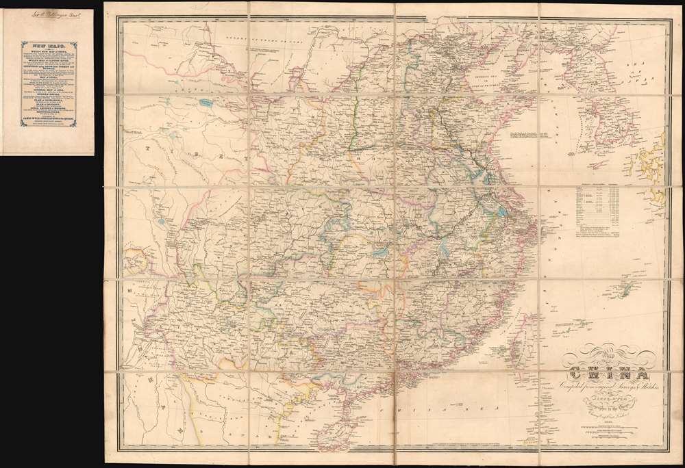
1841 Wyld Map of China (First Opium War)
1841 (dated) $1,500.00
1840 Wyld Map of China (First Opium War) owned by Pottinger, 1st Gov. of Hong Kong
China-wyld-1840$900.00

Title
Map of China Compiled from original Surveys and Sketches.
1840 (dated) 25.5 x 32 in (64.77 x 81.28 cm) 1 : 15000000
1840 (dated) 25.5 x 32 in (64.77 x 81.28 cm) 1 : 15000000
Description
A beautiful example of the scarce 1840 first edition of James Wyld's First Opium War Era map of China, with provenance to Sir Henry Pottinger, the first governor of Hong Kong, identified here as 'Heong Kong'. The map covers all of China, extending from the Tibet border to western Japan and from Manchuria to Hainan. Korea, rendered in full, is wildly malformed. Taiwan, appearing near the cartouche, is misshaped and only the western coast features any detail. There are notes in industry, transportation networks, the great wall, population, trade resources, and more.
In 1839, the Daoguang Emperor, seeking to stem the tide of narcotic addiction in China, banned opium entirely and blockaded China’s only open trade port – Canton (modern day Guangzhou). They also seized and destroyed nearly 20,000 chests, roughly 1200 tons, of opium. Foreign traders within Canton were confined to their offices without access to outside food or supplies – essentially forcing them into a ‘capitulate or starve’ situation.
The British subsequently dispatched a naval and military force to China. The Royal Navy used its cannon power to inflict a series of decisive defeats on the Qing at various Chines ports, forcing them to the negotiating table - a tactic later referred to as ‘gunboat diplomacy.’ By 1842, when this map was drawn, the Qing were forced to sign the Treaty of Nanking, the first of the Unequal Treaties. The Treaty of Nanking created five open treaty ports and ceded Hong Kong to the British Empire. The Opium trade quickly resumed, but escalating tensions led to the Second Opium War (1856 - 1860) just 14 years later in 1856.
One year later, in 1841, he accepted Foreign Secretary Lord Palmerston's offer to become envoy and plenipotentiary in China and superintendent of British trade. There can be little doubt that he acquired this map at that time, in anticipation of his voyage to China and subsequent posting. The fact that this is the first edition, 1840, rather than the updated 1841 edition, suggests he must have acquired it in London early in 1841.
His instructions from Palmerston included specific instructions regarding Hong Kong,
The First Opium War
The First Opium War, or the Anglo-Chinese War, (1839 - 1842) was a series of engagements fought between the United Kingdom and Qing China over trade and diplomatic relations. By the middle of the 19th century an enormous trade imbalance had developed between Europe and China due to high demand for Chinese goods (silk, porcelain, tea) in Europe and low demand for European goods (English wool anyone?) in China. To balance the trade, the British East India Company introduced Indian-grown opium to the Chinese market. The opium trade led to waves of addiction throughout China and reversed the trade imbalance within a couple of years.In 1839, the Daoguang Emperor, seeking to stem the tide of narcotic addiction in China, banned opium entirely and blockaded China’s only open trade port – Canton (modern day Guangzhou). They also seized and destroyed nearly 20,000 chests, roughly 1200 tons, of opium. Foreign traders within Canton were confined to their offices without access to outside food or supplies – essentially forcing them into a ‘capitulate or starve’ situation.
The British subsequently dispatched a naval and military force to China. The Royal Navy used its cannon power to inflict a series of decisive defeats on the Qing at various Chines ports, forcing them to the negotiating table - a tactic later referred to as ‘gunboat diplomacy.’ By 1842, when this map was drawn, the Qing were forced to sign the Treaty of Nanking, the first of the Unequal Treaties. The Treaty of Nanking created five open treaty ports and ceded Hong Kong to the British Empire. The Opium trade quickly resumed, but escalating tensions led to the Second Opium War (1856 - 1860) just 14 years later in 1856.
War and Trade
The First Opium War as essentially about trade, and so is this map. Throughout, Wyld offers a wealth of detail regarding trading and resources throughout China. He identifies black tea regions, green tea regions, cotton fields (near Shanghai), china ware manufactories, silk worm lands, varnish trees, rice grounds, limestone, blue nankeen manufactories, and a place where 'silken fowls are bread.'Property of Sir Henry Pottinger - First Governor of Hong Kong
Lieutenant General Sir Henry Pottinger, 1st Baronet, (砵甸乍, October 3, 1789 – 18 March 18,1856), was an Anglo-Irish soldier and colonial administrator who became the first Governor of Hong Kong. Pottinger represents the absolute best of the British East India Service. He was born in County Down, Ireland and studied at the Belfast Academy before joining the army in India in 1804. In 1806, he joined the British East India Company, serving as a Lieutenant in the 1809 Anglo-Mahratta Wars. In the following year, he partnered with Charles Christie on a bold expedition to map the route from Nushki (Balochistan) to Isfahan (Central Persia). He and Christie disguised themselves as Muslims, separated ways, and both mapped separated routes, before they rejoined in Isfahan. It would be 100 years before another European took this route. The achievement earned him a promotion to Colonel. He became the Resident Administer of Sindh in 1820, and of in the 1830s. In 1839 word reached India that he was to be ennobled and he returned to England to accept the rank of Baronet.One year later, in 1841, he accepted Foreign Secretary Lord Palmerston's offer to become envoy and plenipotentiary in China and superintendent of British trade. There can be little doubt that he acquired this map at that time, in anticipation of his voyage to China and subsequent posting. The fact that this is the first edition, 1840, rather than the updated 1841 edition, suggests he must have acquired it in London early in 1841.
His instructions from Palmerston included specific instructions regarding Hong Kong,
…examine with care the natural capacities of Hong Kong, and you will not agree to give up that Island unless you should find that you can exchange it for another in the neighborhood of Canton, better adapted for the purposes in view; equally defensible; and affording sufficient shelter for Ships of War and Commerce.Palmer went on to negotiate the 1842 Treaty of Nanking, which ended the First Opium War, resulting in the cession of Hong Kong Island to the British Crown. Pottinger subsequently became the second Administrator of Hong Kong (1841–1843) and the first Governor of Hong Kong (1843–1844). Pottinger was enamored of the island, writing,
the retention of Hong Kong is the only point in which I have intentionally exceeded my modified instructions, but every single hour I have passed in this superb country has convinced me of the necessity and desirability of our possessing such a settlement as an emporium for our trade and a place from which Her Majesty's subjects in China may be alike protected and controlled. Of course, he was correct and Hong Kong went to become the crown jewel of British colonial enterprise in the far east. Pottinger afterwards went on to be governor of the Cape Colony in 1847, and Governor of Madras in 1848.Publication History and Census
James Wyld first published this map in 1840 to capitalize on British public interest in the First Opium War (1839 - 1842). Subsequent editions were issued in 1841, 1842, 1843, and 1844. While later editions of Wyld's map are reasonably common, the first edition is remarkably rare on the market.
Cartographer
Wyld (1823 - 1893) was a British publishing firm active throughout the 19th century. It was operated by James Wyld I (1790 - 1836) and his son James Wyld II (November 20, 1812 - 1887) were the principles of an English mapmaking dynasty active in London during much of the 19th century. The elder Wyld was a map publisher under William Faden (1749 - 1836) and did considerable work on the Ordinance Survey. On Faden's retirement in 1823, Wyld took over Faden's workshop, acquiring many of his plates. Wyld's work can often be distinguished from his son's maps through his imprint, which he signed as 'Successor to Faden'. Following in his father's footsteps, the younger Wyld joined the Royal Geographical Society in 1830 at the tender age of 18. When his father died in 1836, James Wyld II was prepared to fully take over and expand his father's considerable cartographic enterprise. Like his father and Faden, Wyld II held the title of official Geographer to the Crown, in this case, Queen Victoria. In 1852, he moved operations from William Faden's old office at Charing Cross East (1837 - 1852) to a new, larger space at 475 Strand. Wyld II also chose to remove Faden's name from all of his updated map plates. Wyld II continued to update and republish both his father's work and the work of William Faden well into the late 1880s. One of Wyld's most eccentric and notable achievements is his 1851 construction of a globe 19 meters (60 feet) in diameter in the heart of Leicester Square, London. In the 1840s, Wyld also embarked upon a political career, being elected to parliament in 1847 and again in 1857. He died in 1887 following a prolific and distinguished career. After Wyld II's death, the family business was briefly taken over by James John Cooper Wyld (1844 - 1907), his son, who ran it from 1887 to 1893 before selling the business to Edward Stanford. All three Wylds are notable for producing, in addition to their atlas maps, short-run maps expounding upon important historical events - illustrating history as it was happening - among them are maps related to the California Gold Rush, the New South Wales Gold Rush, the Scramble for Africa, the Oregon Question, and more. More by this mapmaker...
Condition
Very good. Original linen stable. Signed by Pottinger on the verso. The second panel from the left, second row from the bottom, has been attached upside down. While a restorer could easily correct this matter, we have left it as is, reflecting an authentic artifact. The map folds into its original slipcase constructed of embossed dark green paper.
References
OCLC 4577124.