This item has been sold, but you can get on the Waitlist to be notified if another example becomes available, or purchase a digital scan.
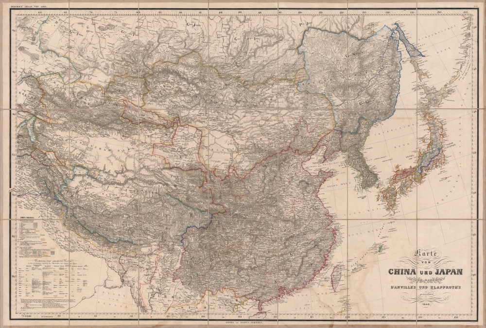
1843 Berghaus / Perthes Map of East Asia, China, Korea, Japan
ChinaJapan-perthes-1843$500.00


Title
Karte von China und Japan den Manen D'Anville's und Klapproth's.
1843 (dated) 27 x 39 in (68.58 x 99.06 cm) 1 : 7000000
1843 (dated) 27 x 39 in (68.58 x 99.06 cm) 1 : 7000000
Description
A gorgeous large-format 1843 map of East Asia by Heinrich Berghaus, published by Justus Perthes. It was published in the immediate wake of the First Opium War (1839 - 1842), which opened China to increased foreign trade and sparked a global interest in the vast empire. Moreover, Berghaus provides tremendous geographical detail, underscoring the immensity of the Qing China and its potential as a source of good and resources.
Historical Context
Significantly, this map was published in the wake of the First Opium War, the starting point of China's disastrous 'century of national humiliation'. The influence of the recent war is evident in the underlining in red of the first five treaty ports (Guangzhou, Xiamen, Fuzhou, Ningbo, Shanghai) as well as Hong Kong, which was ceded to Britain in 1842. In German lands there was considerable commercial and cultural interest in China. Later, in the wake of the Second Opium War (1856 - 1860), Prussia signed a treaty with the Qing similar to those held by other Western powers, allowing for its subjects to trade and travel in China.Sources
This map draws on multiple sources. These include d'Anville's 1737 map of China, itself based on early 18th century Jesuit land surveys carried out on behalf of the Qing. These surveys were accurate enough that d'Anville's map proved the standard Western map of China well into the 19th century. The works of Heinrich Julius Klaproth, one of 19th century Europe's great Orientalist scholars, were another important influence, particularly on placenames and the tables at bottom-left of equivalent terms in multiple languages and an explanation of Chinese administrative terms.Cultural and Political Divisions
Interestingly, rather than being displayed as a single unit (typically 'Chinesischen Reich' on German maps of the era), the Qing Empire is divided into China Proper (i.e., the territory of the preceding Ming Dynasty), Manchuria, Mongolia, Tibet, and Xinjiang (Westland). Though ruled by a single Manchu emperor, these areas were administered differently, with the Qing emperors taking great pains to appeal to and accommodate disparate cultures, religions, and mores. Chinese tributary states and protectorates (Korea, the Ryukyus, and Ladakh) are also indicated, revealing the truly enormous range of Qing suzerainty.Northwestern China
The geography of northwestern China is atypical, with a very long arm of Gansu (Kansu) Province stretching well into Xinjiang to include Urumqi (Urum tsi). In Xinjiang, Mongol or Turkic placenames are used much more often than Chinese ones, an indication of the area's history and culture but also likely both Berghaus and Klaproth's own interests and familiarity with those regions/languages. As a note explains, the borders between the Qing realm, neighboring khanates, and the growing Russian Empire were not well defined, and in fact a good deal of the territory marked here as belonging to the Qing was later delegated to the Russian Empire and is now part of Kazakhstan.Japan
Although not part of China, Japan is also subdivided into constituent parts, evidently historical regions rather than contemporary administrative divisions. Sakhalin is depicted as divided, with the northern half assigned to the Qing and the southern half outlined in a light yellow, likely meant to represent Ainu lands, though it is named using an approximation of the Japanese name for the island, Karafuto. In the following years and decades, Japan and Russia would argue over control of the island, a dispute which has lasted to the present day. The Korean peninsula is misshapen, and the borders of Joseon are extended well into Manchuria.Publication History and Census
This map was prepared by Heinrich Berghaus and printed in 1843 by Justus Perthes. It was engraved by (August) Mädel (about whom little is known), and was printed as Map No. 2 for Berghaus' Atlas von Asia. Rather than being printed and bound together as is typically the case with an atlas, these large, two-sheet maps were issued separately and successively over the course of several years. Nineteen maps were planned but four were never issued. Both the individual maps and atlas as a whole are quite scarce, with the map being held by about twenty institutions, mostly in Europe, and being scarce to the market. This example looks to be especially rare in that it is dissected and laid on linen for folding.CartographerS
Heinrich Karl Wilhelm Berghaus (May 3, 1797 – February 17, 1884) was a German (Prussian) geographer who founded the Geographische Kunstschule in Potsdam and trained several important German geographers and cartographers of the late 19th century, including August Heinrich Petermann and his nephew Hermann Berghaus. The elder Berghaus also was a friend and associate of Alexander von Humboldt, producing some of the maps in his publications. In 1837, he inherited the Daniel Gottlob Reymann (1759 – 1837) monumental Geographischer Specialatlas von Deutschland. Berghaus is best known for his own influential and wide-ranging atlases, namely Atlas von Asien, published between 1833 and 1837, and Berghaus' Physikalischer Atlas, published in multiple editions in the 1830s - 1840s. Although Atlas von Asien was a commercial failure, it was regarded as a work of supreme quality, boosting the reputation of the publisher Justus Perthes and setting up their next collaboration, Berghaus' Physikalischer Atlas, for success. More by this mapmaker...
Johan Georg Justus Perthes (September 11, 1749 - May 2, 1816) was one of the most important German cartographic engravers of the 19th century. He was born in the Thuringian town of Rudolstadt, the son of a court physician. In 1778, he began working as a bookseller in Gotha. Perthes began his publishing empire shortly thereafter with the 1784 issue of the famed survey of European nobility known as the Almanac de Gotha. In the next year, 1785, he founded the cartographic firm of Justus Perthes Geographische Anstalt Gotha. His son Wilhelm Perthes (1793 - 1853) joined the firm in 1814. Wilhelm had prior publishing experience at the firm of Justus Perthes' nephew, Friedrich Christoph Perthes, who ran a publishing house in Hamburg. After Justus Perthes died in 1816, Wilhelm took charge and laid the groundwork for the firm to become a cartographic publishing titan. From 1817 to 1890. the Perthes firm issued thousands of maps and more than 20 different atlases. Along with the visionary editors Hermann Berghaus (1797 - 1884), Adolph Stieler (1775 - 1836), and Karl Spruner (1803 - 1892), the Perthes firm pioneered the Hand Atlas. When Wilhelm retired, management of the firm passed to his son, Bernhardt Wilhelm Perthes (1821 – 1857). Bernhardt brought on the cartographic geniuses August Heinrich Peterman (1822 - 1878) and Bruno Hassenstein (1839 - 1902). The firm was subsequently passed to a fourth generation in the form of Berhanrd Perthes (1858 – 1919), Bernhard Wilhelm's son. The firm continued in the family until 1953 when, being in East Germany, it was nationalized and run as a state-owned enterprise as VEB Hermann Haack Geographisch-Kartographische Anstalt Gotha. The Justus family, led by Joachim Justus Perthes and his son Wolf-Jürgen Perthes, relocated to Darmstadt where they founded the Justus Perthes Geographische Verlagsanstalt Darmstadt. Learn More...
Jean Baptiste Bourguignon d'Anville (1697 - 1782) was perhaps the most important and prolific cartographer of the 18th century. D'Anville's passion for cartography manifested during his school years when he amused himself by composing maps for Latin texts. There is a preserved manuscript dating to 1712, Graecia Vetus, which may be his earliest surviving map - he was only 15 when he drew it. He would retain an interest in the cartography of antiquity throughout his long career and published numerous atlases to focusing on the ancient world. At twenty-two D'Anville, sponsored by the Duke of Orleans, was appointed Geographer to the King of France. As both a cartographer and a geographer, he instituted a reform in the general practice of cartography. Unlike most period cartographers, D'Anville did not rely exclusively on earlier maps to inform his work, rather he based his maps on intense study and research. His maps were thus the most accurate and comprehensive of his period - truly the first modern maps. Thomas Basset and Philip Porter write: "It was because of D'Anville's resolve to depict only those features which could be proven to be true that his maps are often said to represent a scientific reformation in cartography." (The Journal of African History, Vol. 32, No. 3 (1991), pp. 367-413). In 1754, when D'Anville turned 57 and had reached the height of his career, he was elected to the Academie des Inscriptions. Later, at 76, following the death of Philippe Buache, D'Anville was appointed to both of the coveted positions Buache held: Premier Geographe du Roi, and Adjoint-Geographer of the Academie des Sciences. During his long career D'Anville published some 211 maps as well as 78 treatises on geography. D'Anville's vast reference library, consisting of over 9000 volumes, was acquired by the French government in 1779 and became the basis of the Depot Geographique - though D'Anville retained physical possession his death in 1782. Remarkably almost all of D'Anville's maps were produced by his own hand. His published maps, most of which were engraved by Guillaume de la Haye, are known to be near exact reproductions of D'Anville' manuscripts. The borders as well as the decorative cartouche work present on many of his maps were produced by his brother Hubert-Francois Bourguignon Gravelot. The work of D'Anville thus marked a transitional point in the history of cartography and opened the way to the maps of English cartographers Cary, Thomson and Pinkerton in the early 19th century. Learn More...
Heinrich Julius Klaproth (October 11, 1783 - August 28, 1835), also as von Klaproth, was a German linguist and Orientalist who helped develop the academic field of East Asian Studies. Born in Berlin to a father who discovered four elements including uranium, Klaproth was drawn to the study of Asian languages from a young age and had already published a book on the topic by 1802. He briefly undertook studies at the newly-established Oriental Academy in Vilnius before moving on to the Imperial Academy of Sciences in St. Petersburg, where he would have opportunities to learn about the peoples and languages of Russia's expanding empire in the Caucasus and Central Asia. He joined Count Yury Golovkin's abortive 1805 mission to the Qing Court and undertook travels to Siberia, the Caucasus, and elsewhere to gain first-hand knowledge of these cultures. In 1807, he was granted noble status by the Tsar, explaining why his surname sometimes is preceded by 'von.' In 1812, he returned to Berlin and in 1815 moved to Paris, where he was allowed to remain while gaining a title and salary from the King of Prussia for continuing his work on Asian languages and literature. Klaproth lived in Paris for the rest of his life, publishing frequently and helping to found the Société asiatique. He published some 300 works during his life, including an 1812 work on the Uyghur language which advocated the now-standard interpretation that Uyghur is a Turkic language. In his later years, he increasingly focused on Japanese studies. Working with such a wide range of topics and languages meant that Klaproth sacrificed depth for breadth, leading many of his works to later be rejected or superseded by specialists. Nevertheless, he remains one of the key Orientalist scholars of the early 19th century and a pioneer in the study of Asian languages and cultures in the West. Learn More...
Source
Berghaus, H., Berghaus' Atlas von Asia, (Gotha: Justus Perthes) 1843-1847.
Condition
Very good. Dissected and laid on linen. Soiling along bottom margin.
References
OCLC 557812230, 760240857, 71545116, 77547015.