This item has been sold, but you can get on the Waitlist to be notified if another example becomes available, or purchase a digital scan.
1794 Laurie and Whittle Map of China and Korea
ChinaKorea-lauriewhittle-1794$500.00

Title
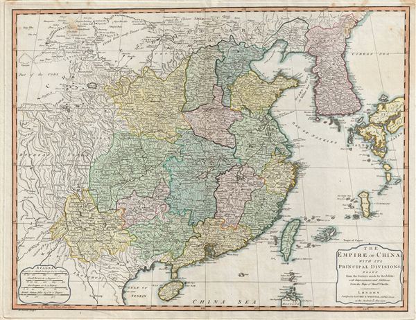
The Empire of China with its Principal Divisions.
1794 (dated) 19 x 25 in (48.26 x 63.5 cm)
1794 (dated) 19 x 25 in (48.26 x 63.5 cm)
Description
A fine 1794 map of China and Korea by the London firm of Laurie and Whittle. Centered on China, this maps covers from Chinese Tartary to the Gulf of Tonkin and the Philippines and from the Gobi Desert to Korea and Japan. The map includes all of China and Korea, as well as Taiwan and adjacent parts of Tibet, Tartary, Japan and the Philippines. China proper is divided by color coding into various provinces. Several segments of the Great Wall of China are indicated. The sea between Japan and Korea, whose name, either the 'Sea of Korea' 'east Sea,' or the 'Sea of Japan,' is currently a matter of historical and political dispute between the countries is here identified in favor of Korea.
Cartographically most of the data on this map is derived from earlier French maps by J. B. B. D'Anville. Stylistically this map presages the functional english school of cartography that would develop in the early 19th century under the patronage of Cary, Thomson, and Pinkerton. This development, of which this piece represents a transitional phase, would do away with many of the decorative embellishments of 18th century maps in exchange for cartographic accuracy and additional detail. engraved by A. Bowen for issue in Laurie and Whittle's 1794 Imperial Atlas.
Cartographically most of the data on this map is derived from earlier French maps by J. B. B. D'Anville. Stylistically this map presages the functional english school of cartography that would develop in the early 19th century under the patronage of Cary, Thomson, and Pinkerton. This development, of which this piece represents a transitional phase, would do away with many of the decorative embellishments of 18th century maps in exchange for cartographic accuracy and additional detail. engraved by A. Bowen for issue in Laurie and Whittle's 1794 Imperial Atlas.
Cartographer
Laurie and Whittle (fl. 1794 - 1858) were London, England, based map and atlas publishers active in the late 18th and early 19th century. Generally considered to be the successors to the Robert Sayer firm, Laurie and Whittle was founded by Robert Laurie (c. 1755 - 1836) and James Whittle (1757-1818). Robert Laurie was a skilled mezzotint engraver and is known to have worked with Robert Sayer on numerous projects. James Whittle was a well-known London socialite and print seller whose Fleet Street shop was a popular haunt for intellectual luminaries. The partnership began taking over the general management of Sayer's firm around 1787; however, they did not alter the Sayer imprint until after Sayer's death in 1794. Apparently Laurie did most of the work in managing the firm and hence his name appeared first in the "Laurie and Whittle" imprint. Together Laurie and Whittle published numerous maps and atlases, often bringing in other important cartographers of the day, including Kitchin, Faden, Jefferys and others to update and modify their existing Sayer plates. Robert Laurie retired in 1812, leaving the day to day management of the firm to his son, Richard Holmes Laurie (1777 - 1858). Under R. H. Laurie and James Whittle, the firm renamed itself "Whittle and Laurie". Whittle himself died six years later in 1818, and thereafter the firm continued under the imprint of "R. H. Laurie". After R. H. Laurie's death the publishing house and its printing stock came under control of Alexander George Findlay, who had long been associated with Laurie and Whittle. Since, Laurie and Whittle has passed through numerous permeations, with part of the firm still extant as an English publisher of maritime or nautical charts, 'Imray, Laurie, Norie and Wilson Ltd.' The firm remains the oldest surviving chart publisher in Europe. More by this mapmaker...
Source
A New and Elegant Imperial Sheet Atlas, comprehending general and particular maps of every part of the world, (London: Laurie and Whittle), 1794.
Condition
Very good condition. Light offsetting. Original centerfold. Original plate mark. Blank on verso.
References
Rumsey 2310.070 (1804 edition). University of Southern California, East Asian Map Collection (Corean Sea, David Lee Collection, EAMC 155. Phillips (Atlases) 716.