
This item below is out of stock, but another example (left) is available. To view the available item, click "Details."
Details
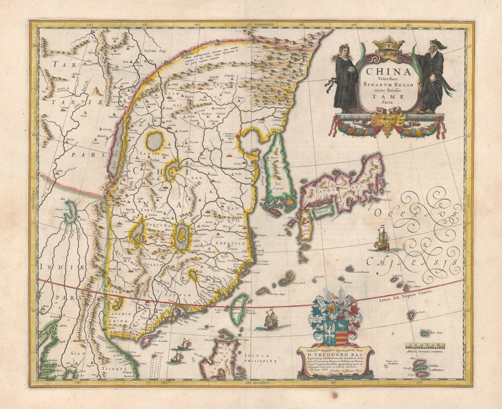
1635 Blaeu Map of China, Japan, and Korea (Korea as an Island)
$2,500.00
1636 Blaeu Map of China, Japan, and Korea (Korea as an Island)
ChinaKoreaJapan-blaeu-1634$1,250.00

Title
China Veteribus Sinarum Regio nunc Incolis Tame dict.
1634 (undated) 16 x 20 in (40.64 x 50.8 cm) 1 : 11750000
1634 (undated) 16 x 20 in (40.64 x 50.8 cm) 1 : 11750000
Description
This is a beautiful example of Willem Blaeu's 1634 map of China, Korea, and Japan. It constitutes the best European knowledge of East Asia prior to the reports of Martino Martini, which in the 1650s caused the complete revision of Blaeu's maps. Major advancements include the mapping of Korea, novel detail in Taiwan / Formosa, and a reconsideration of the authoritative Ortelius/Barbuda map.
A Closer
The map covers from Pegu (modern Burma) in the west to the Ladrones (the Mariana Islands) in the east, and from the Philippines, to the Great Wall, thus embracing northern parts of Vietnam, Siam, Taiwan, Mainland China and Japan. Korea appears in an early, insular form.China
Blaeu’s map represents a synthesis of several late 16th century maps, primarily those of Abraham Ortelius. Ortelius updated his own work considerably in the 1580s and 90s, notably after the reports of the Portuguese cartographer Luiz Jorge de Barbuda (Ludovicus Georgius) and Luis Teixeira. Barbuda's China looms large here, although Blaeu orients it to the north rather than Ortelius' famous western orientation.Korea
The Ortelius / Barbuda map did not include Korea in any form - it was well outdated by 1634. It was on the 1595 Texeira map than an insular Korea appeared for the first time. Like Hondius in 1606, Blaeu here incorporates the state-of-the-art Texeira Japan-Korea geography with the authoritative Barbuda China. Blaeu's treatment of Korea is improved over its precursors by the squaring off of its southern coastline, and the inclusion of the archipelago exhibited here. The large I. de Ladrones (Jeju Island), improves on the tiny island identified on Ortelius and Hondius maps.Taiwan
Taiwan appears in then-unprecedented detail, with three place names: Gillira, Wanakn, and Taroan. We are uncertain of the sources, as the Vingboons map did not appear until about 1640.Apocryphal Lake Chiamay
The mythical Lake of Chiamay appears at the western extreme of the map, roughly in what is today Assam, India. Early cartographers postulated that such a lake must exist to source the four important Southeast Asian river systems: the Irrawaddy, the Dharla, the Chao Phraya, and the Brahmaputra. This lake began to appear in maps of Asia as early as the 16th century and persisted well into the mid-18th century. Its source are unknown, but may originate in a lost 16th century geography prepared by the Portuguese scholar Joao de Barros. It was also heavily discussed in the journals of Sven Hedin, who believed it to be associated with Indian legend that a sacred lake, Mansarovar, linked several of the holy Subcontinent river systems. There are even records that the King of Siam led an army to take control of the lake in the 16th century. The notion of Lake Chiamay was ultimately disproved, and it disappeared from maps entirely by the 1760s.Dedication to Theodore Bas
There is a beautiful dedicatory cartouche to Theodore Bas, a director of the Dutch East India Company or VOC, whose arms are displayed upon it. Bas’ patronage would have been highly desirable to Blaeu, who needed the wealthy organization’s patronage to both acquire the most up to date cartographic data as well as to sell his maps.Publication History and Census
This map was engraved in 1634 for inclusion in the Blaeu atlases, first appearing in the 1634 German edition of the Novus Atlas. The present example corresponds typographically with the 1643 French Théâtre du Monde. The map itself ran unchanged in the atlases until it was completely replaced in 1655 by an new map based on the Martini geography. The separate map is well represented in institutional collections.CartographerS
Joan (Johannes) Blaeu (September 23, 1596 - December 21, 1673) was a Dutch cartographer active in the 17th century. Joan was the son of Willem Janszoon Blaeu, founder of the Blaeu firm. Like his father Willem, Johannes was born in Alkmaar, North Holland. He studied Law, attaining a doctorate, before moving to Amsterdam to join the family mapmaking business. In 1633, Willem arranged for Johannes to take over Hessel Gerritsz's position as the official chartmaker of the Dutch East India Company, although little is known of his work for that organization, which was by contract and oath secretive. What is known is his work supplying the fabulously wealthy VOC with charts was exceedingly profitable. Where other cartographers often fell into financial ruin, the Blaeu firm thrived. It was most likely those profits that allowed the firm to publish the Theatrum Orbis Terrarum, sive, Atlas Novus, their most significant and best-known publication. When Willem Blaeu died in 1638, Johannes, along with his brother Cornelius Blaeu (1616 - 1648) took over the management of the Blaeu firm. In 1662, Joan and Cornelius produced a vastly expanded and updated work, the Atlas Maior, whose handful of editions ranged from 9 to an astonishing 12 volumes. Under the brothers' capable management, the firm continued to prosper until the 1672 Great Amsterdam Fire destroyed their offices and most of their printing plates. Johannes Blaeu, witnessing the destruction of his life's work, died in despondence the following year. He is buried in the Dutch Reformist cemetery of Westerkerk. Johannes Blaeu was survived by his son, also Johannes but commonly called Joan II, who inherited the family's VOC contract, for whom he compiled maps until 1712. More by this mapmaker...
Willem Janszoon Blaeu (1571 - October 18, 1638), also known as Guillaume Blaeu and Guiljelmus Janssonius Caesius, was a Dutch cartographer, globemaker, and astronomer active in Amsterdam during the late 16th and early 17th centuries. Blaeu was born 'Willem Janszoon' in Alkmaar, North Holland to a prosperous herring packing and trading family of Dutch Reformist faith. As a young man, he was sent to Amsterdam to apprentice in the family business, but he found the herring trade dull and instead worked for his cousin 'Hooft' as a carpenter and clerk. In 1595, he traveled to the small Swedish island of Hven to study astronomy under the Danish Enlightenment polymath Tycho Brahe. For six months he studied astronomy, cartography, instrument making, globe making, and geodesy. He returned to Alkmaar in 1596 to marry and for the birth of his first son, Johannes (Joan) Blaeu (1596 – 1673). Shortly thereafter, in 1598 or 1599, he relocated his family to Amsterdam where he founded the a firm as globe and instrument makers. Many of his earliest imprints, from roughly form 1599 - 1633, bear the imprint 'Guiljelmus Janssonius Caesius' or simply 'G: Jansonius'. In 1613, Johannes Janssonius, also a mapmaker, married Elizabeth Hondius, the daughter of Willem's primary competitor Jodocus Hondius the Elder, and moved to the same neighborhood. This led to considerable confusion and may have spurred Willam Janszoon to adopt the 'Blaeu' patronym. All maps after 1633 bear the Guiljelmus Blaeu imprint. Around this time, he also began issuing separate issue nautical charts and wall maps – which as we see from Vermeer's paintings were popular with Dutch merchants as decorative items – and invented the Dutch Printing Press. As a non-Calvinist Blaeu was a persona non grata to the ruling elite and so he partnered with Hessel Gerritsz to develop his business. In 1619, Blaeu arranged for Gerritsz to be appointed official cartographer to the VOC, an extremely lucrative position that that, in the slightly more liberal environment of the 1630s, he managed to see passed to his eldest son, Johannes. In 1633, he was also appointed official cartographer of the Dutch Republic. Blaeu's most significant work is his 1635 publication of the Theatrum orbis terrarum, sive, Atlas Novus, one of the greatest atlases of all time. He died three years later, in 1638, passing the Blaeu firm on to his two sons, Cornelius (1616 - 1648) and Johannes Blaeu (September 23, 1596 - December 21, 1673). Under his sons, the firm continued to prosper until the 1672 Great Fire of Amsterdam destroyed their offices and most of their printing plates. Willem's most enduring legacy was most likely the VOC contract, which ultimately passed to Johannes' son, Johannes II, who held the position until 1617. As a hobbyist astronomer, Blaeu discovered the star now known as P. Cygni. Learn More...
Source
Blaeu, W., Le Théâtre du Monde ou Nouvel Atlas, (Amsterdam: Blaeu) 1636.
In 1662 Joan Blaeu published his masterwork, which has been described as 'the greatest and finest atlas ever published' (Verwey, 1952): his monumental, eleven-volume Atlas Maior. This contained nearly six hundred maps, more than two hundred in excess of the Blaeus' mainstay the Atlas Novus. The former work already being renowned for the quality and beauty of its maps, Blaeu not only added copious material but improved the sophistication of his work: many of the newly-added maps utilized larger-sized presses and sheets, and the artistry applied to the engravings was often far superior to that of the earlier maps in the atlas - many of which by now were 30, and some more than 50 years old. Blaeu's Atlas Maior was published from 1662 to 1672, consisting of some 594 maps compiled into upwards of 9 volumes with some editions containing as many as 12 volumes. This triumphant work's publishing life was cut violently short when, in 1672, the Blaeu's mammoth workshop was destroyed by fire; surviving stock would be sold at auction between 1674 and 1677, occasionally appearing under the imprint of later Dutch printers such as Pieter Schenk and Pieter Mortier. The maps added to the Atlas Maior, owing to their tragically short publishing life, are among the hardest-to-find of the Blaeu maps.
Condition
Excellent. Few spots. Fine original color.
References
OCLC 25779492.