This item has been sold, but you can get on the Waitlist to be notified if another example becomes available, or purchase a digital scan.
1938 Sato Manga or Cartoon WWII Propaganda Map of China
ChinaMangaMap-japanese-1938$875.00

Title
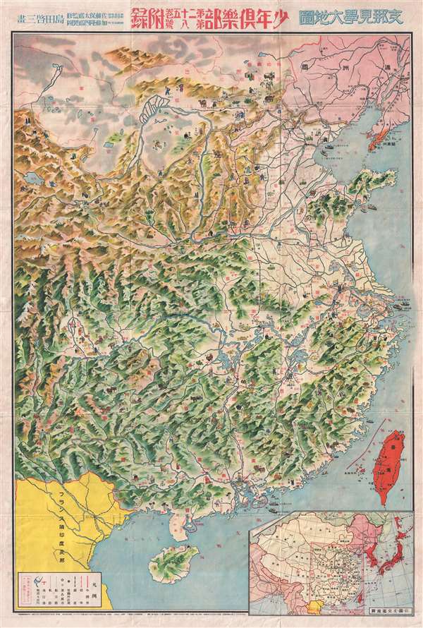
支那見學大地圖 / Large Map of China.
1938 (dated) 36.26 x 24.5 in (92.1004 x 62.23 cm) 1 : 3400000
1938 (dated) 36.26 x 24.5 in (92.1004 x 62.23 cm) 1 : 3400000
Description
A rare 1938 Showa 13 World War II manga style propaganda map of China by the Japanese painter and manga artist Kato Takashiro. Published for the Japanese Youth Club or Shonan Club, this map illustrates all of China with manga style illustrations of Chinese workers engaged in a variety of tasks. It also illustrates shipping and transportation networks throughout China.
The map is designed to lionize Japanese achievements during the 1837-1838 invasion of Japan. In Nanjing, a 'happy' Chinese man flies the quinta-color Chinese Republic National Flag (1912 – 1929) which was revived by the Japanese following the invasion to represent the puppet regime (1937/38 -1945). In Beijing, a Japanese soldier holds a Chinese child who carries the Japanese Flag. Nearby a Chinese civilian holds the quinta-color puppet regime ensign. Manchuria is colored in pink, indicating Japanese dominance, while Korea, Taiwan, the conquered Manchurian port of Dalian, and Japan itself is dark red, indicating that these areas are fully integrated into Imperial Japan.
The verso features some 72 images illustrating the accomplishments of the Japanese Empire in the invasion of China. Most of the references cover the period between July 7, 1937 Marco Polo Bridge Incident (Lugouqiao) to Japanese occupation of Xuzhou on May 19, 1938. That this map was intended for Japanese schools to support the 東京高等師範學校教論 (Tokyo Higher Normal School Teaching Doctrine) is indicative of the militarization of Japanese youth in the early days of World War II.
This map was published as an addendum to the Japanese Youth Club magazine Vol. 25 No. 8. It was drawn by Kato Takashiro (加藤隆四郎) and published under the supervision of Yasutarō Satō (佐藤裕太郎), a teacher of Tokyo Higher Normal School. It was issued on July 1 of 1938.
Cartographer
Satō Yasutarō (佐藤裕太郎; March 5, 1893 – March 7, 1977), or Satō Yūtarō, was a Japanese educator active in Tokyo during the Taisho and Showa Eras. During and just prior to World War II, he worked with the Japanese Youth Club (少年俱樂部), a popular magazine which published several important manga maps of East Asia. After the war, Yasutarō became a professor at Tokyo University of Education and later, the the Senshu University. More by this mapmaker...
Condition
Very good. Minor wear along original fold lines and at fold intersections. Japanese propaganda printed on verso.