This item has been sold, but you can get on the Waitlist to be notified if another example becomes available, or purchase a digital scan.
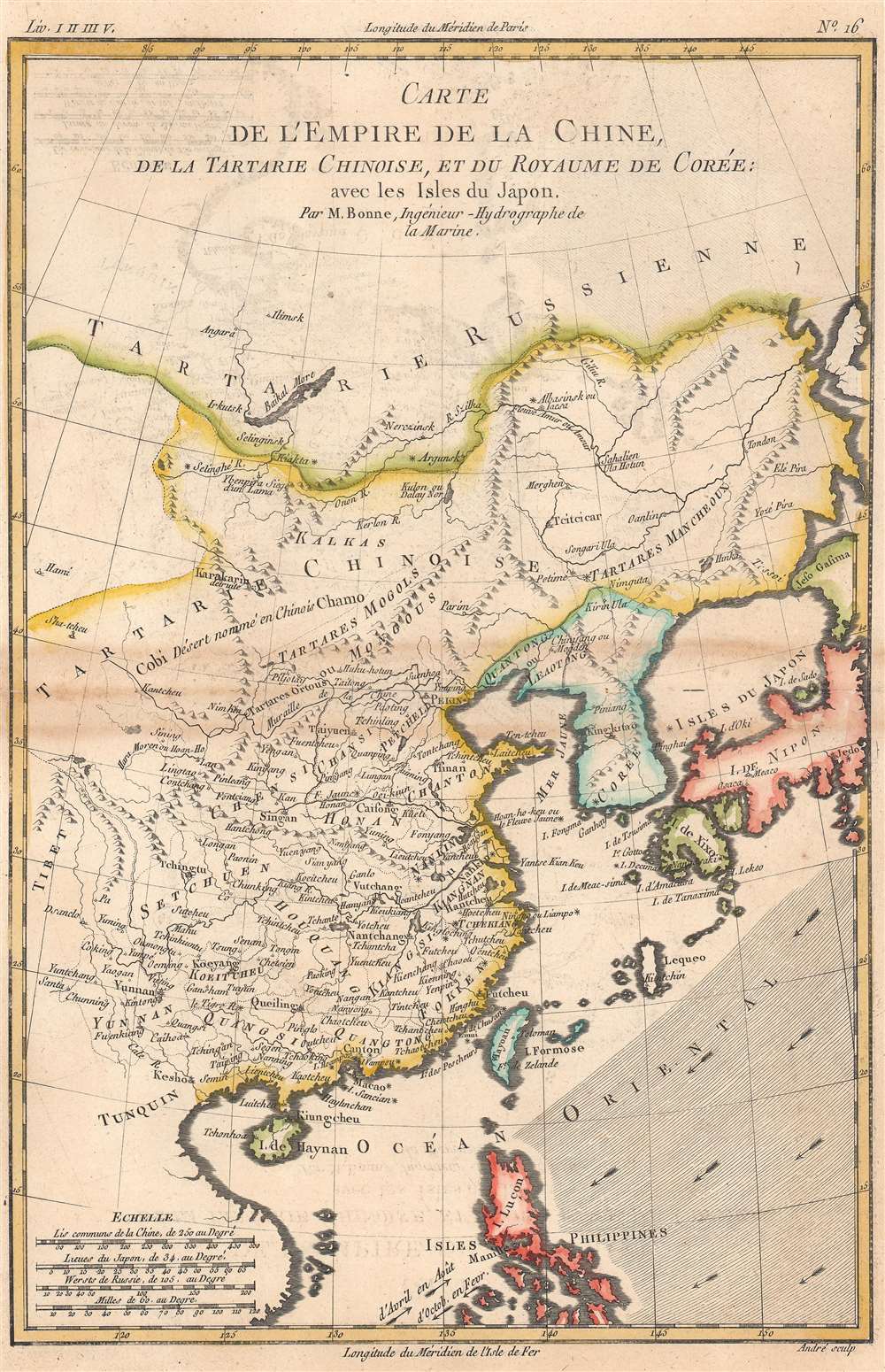
1780 Raynal / Bonne Map of China, Korea, and Japan
Chine-bonne-1780-2$87.50

Title
Carte de l'Empire de la Chine.
1780 (undated) 13.25 x 9 in (33.655 x 22.86 cm) 1 : 21000000
1780 (undated) 13.25 x 9 in (33.655 x 22.86 cm) 1 : 21000000
Description
This is Rigobert Bonne and Guillame Raynal's 1780 map of China, Japan, and Korea. Coverage extends from 'Tartary' south as far as the Philippines, roughly corresponding to the modern-day countries of Vietnam, North Korea, South Korea, Mongolia, China, Japan, and the Philippines.
Of note, the bottom-left hand corner includes four scales, Chinese li, Japanese ri, Russian versts, and French milles. Longitude is measured both from Paris and the Isle de Fer (El Hierro), the westernmost of the Canary Islands, also known as the Ferro meridian. Seasonal trade winds are also indicated at bottom near Luzon.
A Closer Look
The map offers considerable inland detail on the mainland, especially in China and Tartary (including the ruins of the Mongol capital of Karakorum, here as Karakarin), however, the interiors of Japan, Taiwan (Formosa) and the Philippines are entirely unknown. Although this map dates to c. 1780, it presents China at an earlier date, either in the late Ming or the early Qing, before the dissolution of Huguang and Jiangnan Provinces (here Houquang and Kiangnan). This is because Bonne was working from one of a small number of reliable maps of China available in 18th century Europe, most likely Jean-Baptiste Bourguignon d'Anville's c. 1730 map, considered the 'gold standard' into the 19th century.Of note, the bottom-left hand corner includes four scales, Chinese li, Japanese ri, Russian versts, and French milles. Longitude is measured both from Paris and the Isle de Fer (El Hierro), the westernmost of the Canary Islands, also known as the Ferro meridian. Seasonal trade winds are also indicated at bottom near Luzon.
Publication History and Census
This map was drawn by Bonne for Raynal's Atlas de Toutes les Parties Connues du Globe Terrestre, Dressé pour l'Histoire Philosophique et Politique des Établissemens et du Commerce des Européens dans les Deux Indes. It was engraved by Gaspard André, an individual about whom little is known (not to be confused with the 19th century architect of the same name). Both the map itself and the entire atlas in this edition are held by numerous libraries in North America and Europe.CartographerS
Rigobert Bonne (October 6, 1727 - September 2, 1794) was one of the most important French cartographers of the late 18th century. Bonne was born in Ardennes à Raucourt, France. He taught himself mathematics and by eighteen was a working engineer. During the War of the Austrian Succession (1740 - 1748) he served as a military engineer at Berg-op-Zoom. It the subsequent years Bonne became one of the most respected masters of mathematics, physics, and geography in Paris. In 1773, Bonne succeeded Jacques-Nicolas Bellin as Royal Cartographer to France in the office of the Hydrographer at the Depôt de la Marine. Working in his official capacity, Bonne compiled some of the most detailed and accurate maps of the period - most on an equal-area projection known erroneously as the 'Bonne Projection.' Bonne's work represents an important step in the evolution of the cartographic ideology away from the decorative work of the 17th and early 18th century towards a more scientific and practical aesthetic. While mostly focusing on coastal regions, the work of Bonne is highly regarded for its detail, historical importance, and overall aesthetic appeal. Bonne died of edema in 1794, but his son Charles-Marie Rigobert Bonne continued to publish his work well after his death. More by this mapmaker...
Guillaume Thomas Raynal (April 12, 1711 - March 6, 1796) was a French writer, philosopher, and historian active during the Enlightenment. Raynal was educated as a Jesuit, but left the order for unknown reasons, and moved to Paris where he dedicated himself to the production of a number of minor but popular historical works. Raynal's histories opened doors to elite social and artistic circles where he met and befriended various members of the Philosophe Coteries. Raynal's most important work is generally considered to be a 1770 collaboration with Diderot and others entitled, L'Histoire philosophique et politique des établissements et du commerce des Européens dans les deux Indes. Some of the philosophical ideas developed in the book drew negative attention from the authorities who banned the book and posted a notice for the arrest of its authors. Raynal fled to Berlin and later to St. Petersburg, where he lived for a number of years before returning to France in 1787. Though not a cartographer Raynal's name is often attached to several Atlases by Rigobert Bonne, from whom he composed the text. Learn More...
Source
Raynal, G., Atlas de Toutes les Parties Connues du Globe Terrestre, Dressé pour l'Histoire Philosophique et Politique des Établissemens et du Commerce des Européens dans les Deux Indes, (Paris) 1780.
Condition
Very good. Slight discoloration along the fold line.
References
Rumsey 3083.031, OCLC 231995353, 837639469, 234186933.